Comanche County, Kansas facts for kids
Quick facts for kids
Comanche County
|
|
|---|---|

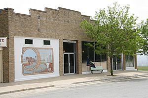
Comanche County Museum in Coldwater (2010)
|
|

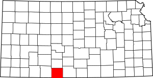
Location within the U.S. state of Kansas
|
|
 Kansas's location within the U.S. |
|
| Country | |
| State | |
| Founded | February 26, 1867 |
| Named for | Comanche Native Americans |
| Seat | Coldwater |
| Largest city | Coldwater |
| Area | |
| • Total | 790 sq mi (2,000 km2) |
| • Land | 788 sq mi (2,040 km2) |
| • Water | 1.4 sq mi (4 km2) 0.2%% |
| Population
(2020)
|
|
| • Total | 1,689 |
| • Estimate
(2021)
|
1,670 |
| • Density | 2.1/sq mi (0.8/km2) |
| Time zone | UTC−6 (Central) |
| • Summer (DST) | UTC−5 (CDT) |
| Area code | 620 |
| Congressional district | 4th |
Comanche County is a county in the state of Kansas. It's a place where people live and work, just like a big neighborhood. The main town and biggest city in the county is Coldwater. In 2020, about 1,689 people lived here. The county got its name from the Comanche tribe, a group of Native Americans.
Contents
History of Comanche County
For thousands of years, the Great Plains of North America were home to Native American tribes. These groups often moved around, following animals and seasons.
In 1854, the area became known as the Kansas Territory. Then, in 1861, Kansas officially joined the United States as the 34th state.
Comanche County itself was created in 1867. It was named to honor the Comanche Native Americans, who were important in the history of this region.
Geography of Comanche County
Comanche County is located in Kansas. It covers a total area of about 790 square miles. Most of this area is land, with only a small part being water.
Counties Nearby
Comanche County shares its borders with several other counties:
- Kiowa County (to the north)
- Barber County (to the east)
- Woods County, Oklahoma (to the south)
- Harper County, Oklahoma (to the southwest)
- Clark County (to the west)
People of Comanche County
| Historical population | |||
|---|---|---|---|
| Census | Pop. | %± | |
| 1880 | 372 | — | |
| 1890 | 2,549 | 585.2% | |
| 1900 | 1,619 | −36.5% | |
| 1910 | 3,281 | 102.7% | |
| 1920 | 5,302 | 61.6% | |
| 1930 | 5,238 | −1.2% | |
| 1940 | 4,412 | −15.8% | |
| 1950 | 3,888 | −11.9% | |
| 1960 | 3,271 | −15.9% | |
| 1970 | 2,702 | −17.4% | |
| 1980 | 2,554 | −5.5% | |
| 1990 | 2,313 | −9.4% | |
| 2000 | 1,967 | −15.0% | |
| 2010 | 1,891 | −3.9% | |
| 2020 | 1,689 | −10.7% | |
| 2023 (est.) | 1,655 | −12.5% | |
| U.S. Decennial Census 1790–1960 1900–1990 1990–2000 2010–2020 |
|||
In 2000, there were 1,967 people living in Comanche County. These people lived in 872 different homes. About 24% of these homes had children under 18 living there. Many homes were families with married couples.
The people in the county are of different ages. About 22% were under 18 years old. Around 26% were between 45 and 64 years old. And about 25% were 65 years or older. The average age of people in the county was 47 years.
Education in Comanche County
The county has a school district that helps students learn and grow.
Local School District
- Comanche County USD 300
Communities in Comanche County
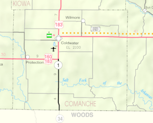
Comanche County has several towns and communities where people live.
Cities in the County
- Coldwater (This is the main town, also called the county seat)
- Protection
- Wilmore
Other Communities
- Buttermilk (This is a smaller community that is not an official city)
Comanche County is also divided into four smaller areas called townships. These help organize the county's land and services.
See also
 In Spanish: Condado de Comanche (Kansas) para niños
 | Georgia Louise Harris Brown |
 | Julian Abele |
 | Norma Merrick Sklarek |
 | William Sidney Pittman |


