
Barber County, Kansas facts for kids
Quick facts for kids
Barber County
|
|
|---|---|

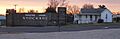
Medicine Lodge Stockade Museum (left) and Carry A. Nation house (right) in Medicine Lodge
|
|

Location within the U.S. state of Kansas
|
|
 Kansas's location within the U.S. |
|
| Country | |
| State | |
| Founded | February 26, 1867 |
| Named for | Thomas W. Barber |
| Seat | Medicine Lodge |
| Largest city | Medicine Lodge |
| Area | |
| • Total | 1,136 sq mi (2,940 km2) |
| • Land | 1,134 sq mi (2,940 km2) |
| • Water | 2.1 sq mi (5 km2) 0.2%% |
| Population
(2020)
|
|
| • Total | 4,228 |
| • Density | 3.7/sq mi (1.4/km2) |
| Time zone | UTC−6 (Central) |
| • Summer (DST) | UTC−5 (CDT) |
| Area code | 620 |
| Congressional district | 4th |
Barber County is a county located in the south-central part of Kansas. Its main town, called the county seat, is Medicine Lodge. This is also the biggest city in the county. In 2020, about 4,228 people lived in Barber County. The county was named after Thomas Barber. He was a person who worked to end slavery and was killed in 1855 during a conflict called the Wakarusa War.
Contents
History of Barber County
Barber County was created in 1867 from parts of other counties. It was officially set up in 1873. The county was named for Thomas Barber, a "free-state" man. He was killed during a time known as Bleeding Kansas. This was when people fought over whether Kansas would allow slavery. The county's name was first spelled "Barbour" by mistake. Later, it was officially changed to "Barber."
The land that became Barber County used to belong to Native American tribes. These included the Osages and the Cherokees. They gave this land to the United States government in 1870. After that, people could buy the land. Early settlers saw many buffalo wallows in the county. These were dips in the ground made by buffalo.
The first settler in the county was a man named Griffin. He moved near Sun City in the winter of 1871-1872. Native Americans did not want white settlers on their land. This led to fighting. In 1872, a raid happened, and a trader named E. H. Mosely was killed. After this, people built strong wooden forts, called stockades. These were built in Medicine Lodge and Sun City for protection.
New towns like Kiowa and Medicine Lodge were started. Many people moved to the area quickly in the summer of 1873. The first baby in the county was born in 1873. The first wedding took place in 1874.
In the summer of 1874, another Native American raid happened. Several settlers along the Medicine Lodge River were killed. People built more stockades to protect themselves. Groups of local soldiers, called militia, were also formed in Medicine Lodge and Sun City.
Many buffalo used to live in the county. But by the 1880s, most of them were gone. The land where they lived was great for raising cattle. In 1870, ranchers in Barber and Comanche counties worked together. They formed a group called the Comanche cattle pool. People also found gypsum in the county. Gypsum is a mineral used to make plaster. A plaster company started in Sun City in 1891.
In 1884, the Medicine Lodge Bank was robbed. A group led by Henry Newton Brown robbed it. The robbers were caught and put in jail. Later that night, a crowd of people took the robbers from jail.
A famous woman named Carrie Nation lived in the area. She was known for fighting against alcohol. In 1900, she broke up her first saloon in Kiowa, Kansas. Today, her old house is a special historical site.
Geography of Barber County
Barber County covers about 1,136 square miles. Most of this area is land. Only a small part, about 2.1 square miles, is water.
The Medicine Lodge River flows through the county.
Neighboring Areas
Barber County shares borders with several other counties:
- To the north: Pratt County
- To the northeast: Kingman County
- To the east: Harper County
- To the southeast: Alfalfa County, Oklahoma
- To the southwest: Woods County, Oklahoma
- To the west: Comanche County
- To the northwest: Kiowa County
Main Roads
These are the most important roads that go through Barber County:
- U.S. Route 160
- U.S. Route 281
- Kansas Highway 2
Population Information

| Historical population | |||
|---|---|---|---|
| Census | Pop. | %± | |
| 1880 | 2,661 | — | |
| 1890 | 7,973 | 199.6% | |
| 1900 | 6,594 | −17.3% | |
| 1910 | 9,916 | 50.4% | |
| 1920 | 9,739 | −1.8% | |
| 1930 | 10,178 | 4.5% | |
| 1940 | 9,073 | −10.9% | |
| 1950 | 8,521 | −6.1% | |
| 1960 | 8,713 | 2.3% | |
| 1970 | 7,016 | −19.5% | |
| 1980 | 6,548 | −6.7% | |
| 1990 | 5,874 | −10.3% | |
| 2000 | 5,307 | −9.7% | |
| 2010 | 4,861 | −8.4% | |
| 2020 | 4,228 | −13.0% | |
| 2023 (est.) | 4,071 | −16.3% | |
| U.S. Decennial Census 1790-1960 1900-1990 1990-2000 2010-2020 |
|||
In 2000, there were 5,307 people living in Barber County. These people lived in 2,235 homes. About 1,510 of these were families. The county had about 5 people per square mile. Most people in the county were White (97.06%). A small number were Black, Native American, or Asian. About 2% of the people were of Hispanic or Latino background.
In the homes, about 28.7% had children under 18. Most homes (58.7%) were married couples living together. About 32.4% of homes were not families. This means they were single people or roommates.
The average age of people in the county was 43 years old. About 25% of the people were under 18. About 21.5% were 65 or older. For every 100 females, there were about 92 males.
The average income for a household in the county was about $33,407 per year. For families, it was about $40,234. About 10.1% of all people in the county lived below the poverty line. This included 12.6% of children under 18.
Education in Barber County
Barber County has several school districts. These districts manage the public schools in the area.
- Barber County North USD 254
- South Barber USD 255
- Skyline Schools USD 438
Communities in Barber County

Barber County has different types of communities. These include cities, small towns that are not officially cities, and places that used to be towns but are now empty.
Cities in Barber County
- Hardtner
- Hazelton
- Isabel
- Kiowa
- Medicine Lodge (This is the county seat, the main town)
- Sharon
- Sun City
Unincorporated Communities
These are small towns or areas that are not officially cities.
Ghost Towns
These are places that used to be communities but are now empty or abandoned.
- Lasswell
- Mingona
- Pixley
Townships
Barber County is divided into eighteen areas called townships. The population numbers for these townships include any cities or towns within them.
| Township | Population center |
Population | Geographic coordinates |
|---|---|---|---|
| Aetna | 3 | 37°5′37″N 98°56′43″W / 37.09361°N 98.94528°W | |
| Deerhead | 11 | 37°13′59″N 98°58′3″W / 37.23306°N 98.96750°W | |
| Eagle | 42 | 37°10′13″N 98°46′22″W / 37.17028°N 98.77278°W | |
| Elm Mills | 106 | 37°25′37″N 98°38′45″W / 37.42694°N 98.64583°W | |
| Elwood | Hardtner | 275 | 37°2′30″N 98°40′35″W / 37.04167°N 98.67639°W |
| Hazelton | Hazelton | 213 | 37°6′7″N 98°24′1″W / 37.10194°N 98.40028°W |
| Kiowa | Kiowa | 1,164 | 37°1′3″N 98°29′19″W / 37.01750°N 98.48861°W |
| Lake City | 83 | 37°21′11″N 98°49′2″W / 37.35306°N 98.81722°W | |
| McAdoo | 29 | 37°26′16″N 98°49′31″W / 37.43778°N 98.82528°W | |
| Medicine Lodge | Medicine Lodge | 2,573 | 37°17′17″N 98°34′5″W / 37.28806°N 98.56806°W |
| Mingona | 57 | 37°17′39″N 98°40′37″W / 37.29417°N 98.67694°W | |
| Moore | 32 | 37°4′9″N 98°32′59″W / 37.06917°N 98.54972°W | |
| Nippawalla | 26 | 37°9′56″N 98°32′5″W / 37.16556°N 98.53472°W | |
| Ridge (defunct, merged with Sharon) | 4 | 37°22′37″N 98°25′7″W / 37.37694°N 98.41861°W | |
| Sharon | Sharon | 369 | 37°14′56″N 98°24′32″W / 37.24889°N 98.40889°W |
| Sun City | Sun City | 100 | 37°22′39″N 98°55′13″W / 37.37750°N 98.92028°W |
| Turkey Creek | 37 | 37°26′6″N 98°55′0″W / 37.43500°N 98.91667°W | |
| Valley | Isabel | 183 | 37°26′6″N 98°31′44″W / 37.43500°N 98.52889°W |
Images for kids
-
Medicine Lodge Stockade Museum (left) and Carry A. Nation house (right) in Medicine Lodge
-
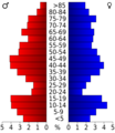
Population pyramid based on 2000 census age data
-
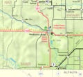
2005 map of Barber County (legend)
See also
 In Spanish: Condado de Barber para niños
