Kingman County, Kansas facts for kids
Quick facts for kids
Kingman County
|
|
|---|---|

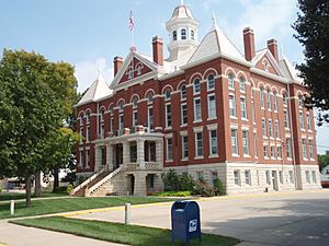
Kingman County Courthouse in Kingman (2009)
|
|

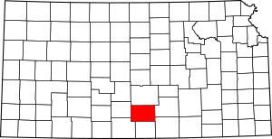
Location within the U.S. state of Kansas
|
|
 Kansas's location within the U.S. |
|
| Country | |
| State | |
| Founded | March 7, 1872 |
| Named for | Samuel Austin Kingman |
| Seat | Kingman |
| Largest city | Kingman |
| Area | |
| • Total | 867 sq mi (2,250 km2) |
| • Land | 863 sq mi (2,240 km2) |
| • Water | 3.3 sq mi (9 km2) 0.4%% |
| Population
(2020)
|
|
| • Total | 7,470 |
| • Estimate
(2023)
|
7,066 |
| • Density | 8.7/sq mi (3.4/km2) |
| Time zone | UTC−6 (Central) |
| • Summer (DST) | UTC−5 (CDT) |
| Congressional district | 4th |
Kingman County is a place in the state of Kansas, USA. It's like a big district or area. The main city and capital of the county is Kingman. In 2020, about 7,470 people lived here. The county got its name from Samuel Austin Kingman, who was a very important judge in Kansas many years ago.
Contents
History of Kingman County
How Kingman County Began
For thousands of years, the Great Plains of North America were home to Native American tribes who moved around a lot.
Later, from the 1500s to the 1700s, France said it owned large parts of North America. But after a big war called the French and Indian War in 1762, France secretly gave this land to Spain.
Becoming Part of the United States
In 1802, Spain gave most of this land back to France. Then, in 1803, the United States bought a huge area from France. This was called the Louisiana Purchase. It included most of what is now Kansas. The U.S. paid a very small amount for all that land!
In 1854, the area became the Kansas Territory. Then, in 1861, Kansas officially became the 34th state in the USA. Kingman County was created in 1872. It was named after Samuel Austin Kingman, who was the chief judge of the Kansas Supreme Court at that time.
Geography of Kingman County
Kingman County covers about 867 square miles. Most of this area, about 863 square miles, is land. Only a small part, about 3.3 square miles, is water.
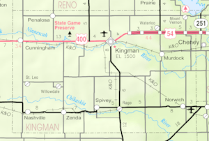
Neighboring Counties
Kingman County shares its borders with several other counties:
- To the north: Reno County
- To the east: Sedgwick County
- To the southeast: Sumner County
- To the south: Harper County
- To the southwest: Barber County
- To the west: Pratt County
People of Kingman County
| Historical population | |||
|---|---|---|---|
| Census | Pop. | %± | |
| 1880 | 3,713 | — | |
| 1890 | 11,823 | 218.4% | |
| 1900 | 10,663 | −9.8% | |
| 1910 | 13,386 | 25.5% | |
| 1920 | 12,119 | −9.5% | |
| 1930 | 11,674 | −3.7% | |
| 1940 | 12,001 | 2.8% | |
| 1950 | 10,324 | −14.0% | |
| 1960 | 9,958 | −3.5% | |
| 1970 | 8,886 | −10.8% | |
| 1980 | 8,960 | 0.8% | |
| 1990 | 8,292 | −7.5% | |
| 2000 | 8,673 | 4.6% | |
| 2010 | 7,858 | −9.4% | |
| 2020 | 7,470 | −4.9% | |
| 2023 (est.) | 7,066 | −10.1% | |
| U.S. Decennial Census 1790-1960 1900-1990 1990-2000 2010-2020 |
|||
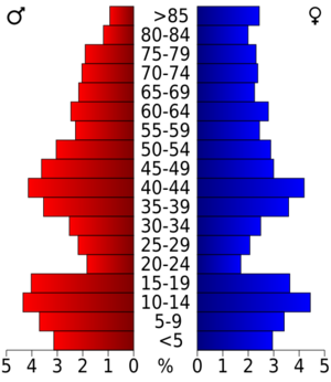
In 2000, there were 8,673 people living in Kingman County. There were about 3,371 homes, and 2,420 of these were families. On average, there were about 10 people per square mile.
Most of the people in the county were White (about 97%). A smaller number were Native American, Asian, Black, or from other backgrounds. About 1.4% of the people were Hispanic or Latino.
About 32% of the homes had children under 18 living there. Most homes (about 62%) were married couples living together. About 26% of all homes were people living alone.
The average age of people in the county was 40 years old. About 27% of the population was under 18, and about 20% was 65 or older.
The average yearly income for a home in the county was about $37,790. For families, it was about $44,547. About 10% of the people in the county lived below the poverty line. This included about 17% of children under 18.
Education in Kingman County
Students in Kingman County attend schools that are part of different school districts. These are:
- Kingman–Norwich USD 331
- Cunningham–West Kingman County USD 332
Communities in Kingman County
Kingman County has several cities and smaller communities.
Cities in Kingman County
Unincorporated Communities in Kingman County
These are smaller towns or areas that don't have their own city government. Some of them are also called "Census-Designated Places" (CDP), which means the U.S. Census Bureau counts them as a specific place.
- Calista
- Cleveland
- Mount Vernon
- Murdock† (CDP)
- Rago
- Skellyville
- St. Leo
- Varner
- Waterloo
- Willowdale
Townships in Kingman County
Kingman County is divided into 23 smaller areas called townships. The city of Kingman is separate and not part of any township's population count. Here are the townships:
- Allen
- Belmont
- Bennett
- Canton
- Chikaskia
- Dale
- Dresden
- Eagle
- Eureka
- Evan
- Galesburg
- Hoosier
- Kingman
- Liberty
- Ninnescah
- Peters
- Richland
- Rochester
- Rural
- Union
- Valley
- Vinita
- White
See also
 In Spanish: Condado de Kingman para niños
 | William L. Dawson |
 | W. E. B. Du Bois |
 | Harry Belafonte |


