
Harper County, Kansas facts for kids
Quick facts for kids
Harper County
|
|
|---|---|

Harper County Courthouse in Anthony (2015)
|
|

Location within the U.S. state of Kansas
|
|
 Kansas's location within the U.S. |
|
| Country | |
| State | |
| Founded | February 26, 1867 |
| Named for | Marion Harper |
| Seat | Anthony |
| Largest city | Anthony |
| Area | |
| • Total | 803 sq mi (2,080 km2) |
| • Land | 801 sq mi (2,070 km2) |
| • Water | 1.5 sq mi (4 km2) 0.2%% |
| Population
(2020)
|
|
| • Total | 5,485 |
| • Estimate
(2023)
|
5,435 |
| • Density | 6.8/sq mi (2.6/km2) |
| Time zone | UTC−6 (Central) |
| • Summer (DST) | UTC−5 (CDT) |
| Area code | 620 |
| Congressional district | 4th |
Harper County is a special area in the state of Kansas, USA. It's like a district with its own local government. The main city and place where the county government works is Anthony. In 2020, about 5,485 people lived here. The county got its name from Sergeant Marion Harper. He was a brave soldier who died during the American Civil War.
Contents
History of Harper County
Early Days and Land Ownership
For thousands of years, the Great Plains of North America were home to Native Americans. These groups often moved around, following animal herds. Later, in the 1500s and 1600s, France said they owned large parts of North America. But after a big war in 1762, France secretly gave this land to Spain.
Then, in 1802, Spain gave most of the land back to France. Soon after, in 1803, the United States bought a huge amount of land from France. This was called the Louisiana Purchase. It included most of what is now Kansas.
How Harper County Was Formed
In 1854, the Kansas Territory was set up. Kansas officially became the 34th U.S. state in 1861. Just a few years later, in 1867, Harper County was officially created.
Interestingly, the first time Harper County was organized, it was part of a big trick! In 1873, some people tried to set up the county. They even named a fake city, "Bluff City," as the county seat. They used names from a city directory to pretend people lived there. But in 1874, an investigation found no real residents. The people behind the trick had sold bonds worth a lot of money.
Harper County was properly settled starting in 1877. It was officially organized for the second time in 1878. Since the first "Bluff City" wasn't real, Anthony became the temporary county seat. In 1879, Anthony was chosen as the permanent county seat after an election.
Recent Times: Oil, Wind, and Changes
Around 2012, Harper County saw a boost in its economy. This was because of new jobs in oil fields and wind farms. Places like Danville, Harper, and Anthony saw rents go up a lot.
However, by 2016, the oil boom slowed down. This caused the economy in Harper County and nearby areas to face challenges. Also, there had been some small earthquakes. These were linked to the oil drilling process. But the number of earthquakes went down after new rules were put in place.
Geography of Harper County
Harper County covers about 803 square miles. Most of this area is land, about 801 square miles. A small part, about 1.5 square miles, is water.
Neighboring Counties
Harper County shares its borders with several other counties:
- To the north: Kingman County
- To the east: Sumner County
- To the southeast: Grant County, Oklahoma
- To the southwest: Alfalfa County, Oklahoma
- To the west: Barber County
People of Harper County

| Historical population | |||
|---|---|---|---|
| Census | Pop. | %± | |
| 1880 | 4,133 | — | |
| 1890 | 13,266 | 221.0% | |
| 1900 | 10,310 | −22.3% | |
| 1910 | 14,748 | 43.0% | |
| 1920 | 13,656 | −7.4% | |
| 1930 | 12,823 | −6.1% | |
| 1940 | 12,068 | −5.9% | |
| 1950 | 10,263 | −15.0% | |
| 1960 | 9,541 | −7.0% | |
| 1970 | 7,871 | −17.5% | |
| 1980 | 7,778 | −1.2% | |
| 1990 | 7,124 | −8.4% | |
| 2000 | 6,536 | −8.3% | |
| 2010 | 6,034 | −7.7% | |
| 2020 | 5,485 | −9.1% | |
| 2023 (est.) | 5,435 | −9.9% | |
| U.S. Decennial Census 1790-1960 1900-1990 1990-2000 2010-2020 |
|||
In 2000, there were 6,536 people living in Harper County. Most people (about 97%) were White. About 1% of the population was of Hispanic or Latino background.
There were 2,773 households. About 28% of these households had children under 18 living with them. The average household had 2.3 people. The average family had 2.9 people.
The population was spread out across different age groups. About 25% were under 18 years old. About 23% were 65 years or older. The average age was 43 years.
Education in Harper County
Students in Harper County attend schools in different unified school districts. These districts manage schools from kindergarten through high school.
School Districts
- Chaparral USD 361
- Attica USD 511
Communities in Harper County

Harper County has several cities and smaller communities.
Cities
- Anthony (This is the county seat, where the main government offices are)
- Attica
- Bluff City
- Danville
- Harper
- Waldron
Unincorporated Communities
These are smaller communities that don't have their own city government.
Ghost Towns
These are places where communities once existed but are now mostly abandoned.
- Albion
- Crisfield
- Midway
- Ruella
- Shook
- Yankton
Townships

Harper County is divided into six areas called townships. Unlike most counties in Kansas, Harper County's townships are numbered instead of named. The cities of Anthony and Harper are separate from these township populations.
| Township | Population | Land area km2 (sq mi) |
Water area km2 (sq mi) |
|---|---|---|---|
| Township 1 | 1,000 | 468 (181) | 1 (0) |
| Township 2 | 144 | 363 (140) | 1 (0) |
| Township 3 | 394 | 383 (148) | 2 (1) |
| Township 4 | 232 | 297 (115) | 0 (0) |
| Township 5 | 463 | 277 (107) | 0 (0) |
| Township 6 | 296 | 280 (108) | 0 (0) |
Images for kids
-
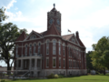
Harper County Courthouse in Anthony (2015)
-
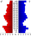
Population pyramid based on 2000 census age data
-
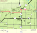
2005 map of Harper County (map legend)
-
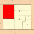
The townships of Harper County (Townships are numbers in counter-clockwise order, with Township 1 highlighted in red).
See also
 In Spanish: Condado de Harper (Kansas) para niños
