Freeport, Kansas facts for kids
Quick facts for kids
Freeport, Kansas
|
|
|---|---|

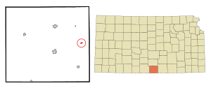
Location within Harper County and Kansas
|
|

|
|
| Country | United States |
| State | Kansas |
| County | Harper |
| Founded | 1885 |
| Area | |
| • Total | 0.20 sq mi (0.52 km2) |
| • Land | 0.20 sq mi (0.52 km2) |
| • Water | 0 sq mi (0 km2) |
| Elevation | 1,339 ft (408 m) |
| Population
(2010)
|
|
| • Total | 5 |
| • Density | 25.0/sq mi (9.6/km2) |
| Time zone | UTC-6 (CST) |
| • Summer (DST) | UTC-5 (CDT) |
| ZIP code |
67049
|
| Area code | 620 |
| FIPS code | 20-24725 |
| GNIS ID | 470290 |
Freeport is a very small place in Harper County, Kansas, United States. It's known as an unincorporated community. This means it doesn't have its own city government. In 2010, only 5 people lived there! Freeport used to be an official city, but it stopped being one in 2017.
Contents
History of Freeport
Before Freeport was officially started, there was another small settlement nearby called Midlothian. This name comes from a Scottish word meaning "Midland."
Midlothian had a few important places. It had a post office that opened in 1879. There was also a local school and a church for the people living there.
Freeport itself was founded in 1885. It was built along the Missouri Pacific Railway line. This railway helped the town grow and connect with other places.
Freeport's Growth and Decline
In the late 1800s, Freeport was a busy and growing town. It had many businesses, like three lumberyards and two places to store grain. There were also nine grocery stores and five dry goods stores. People could find two meat markets, two hardware stores, and three drug stores. The town even had four blacksmiths, one bank, and two hotels.
In 1892, Freeport's population reached its highest point with 700 people living there. The Midlothian post office was moved to Freeport in 1885. Today, the community still has a grain elevator and a church.
For a long time, Freeport was the smallest official city in Kansas. In November 2017, the population had grown slightly to eight people. However, the city was officially dissolved by a vote of 4–0 in the November 2017 election.
Geography of Freeport
Freeport is a small community that covers about 0.20 square miles (0.52 square kilometers). All of this area is land.
The community is surrounded by flat plains and farmland. There are no large bodies of water nearby, and not many trees.
Population Information
| Historical population | |||
|---|---|---|---|
| Census | Pop. | %± | |
| 1890 | 138 | — | |
| 1900 | 83 | −39.9% | |
| 1910 | 161 | 94.0% | |
| 1920 | 56 | −65.2% | |
| 1930 | 105 | 87.5% | |
| 1940 | 67 | −36.2% | |
| 1950 | 30 | −55.2% | |
| 1960 | 31 | 3.3% | |
| 1970 | 21 | −32.3% | |
| 1980 | 12 | −42.9% | |
| 1990 | 8 | −33.3% | |
| 2000 | 6 | −25.0% | |
| 2010 | 5 | −16.7% | |
| U.S. Decennial Census | |||
2010 Population Details
In 2010, the census showed that 5 people lived in Freeport. These people made up 3 households and 2 families.
The community had 4 housing units. Most of the people living there were White (80.0%). A smaller number (20.0%) were Native American.
Among the households, 66.7% were married couples living together. The average household had about 1.67 people. The average family had 2.00 people.
The average age of people in Freeport was 66.5 years old. Most residents (60%) were 65 years or older. There were no residents under 18.
Education
Students in Freeport attend public schools in the Chaparral USD 361 school district.
More Information
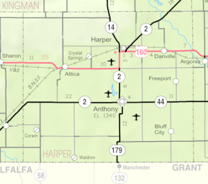
- Freeport Map, KDOT
- Harper County maps: Current, Historic, KDOT
See also
 In Spanish: Freeport (Kansas) para niños
 | Isaac Myers |
 | D. Hamilton Jackson |
 | A. Philip Randolph |

