Grant County, Oklahoma facts for kids
Quick facts for kids
Grant County
|
|
|---|---|

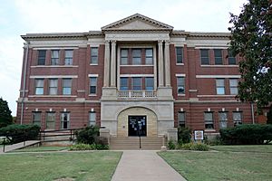
Grant County Courthouse in Medford (2017)
|
|

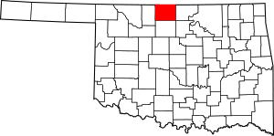
Location within the U.S. state of Oklahoma
|
|
 Oklahoma's location within the U.S. |
|
| Country | |
| State | |
| Founded | 1893 |
| Named for | Ulysses S. Grant |
| Seat | Medford |
| Largest city | Medford |
| Area | |
| • Total | 1,004 sq mi (2,600 km2) |
| • Land | 1,001 sq mi (2,590 km2) |
| • Water | 2.7 sq mi (7 km2) 0.3%% |
| Population
(2020)
|
|
| • Total | 4,169 |
| • Density | 4.2/sq mi (1.6/km2) |
| Time zone | UTC−6 (Central) |
| • Summer (DST) | UTC−5 (CDT) |
| Congressional district | 3rd |
Grant County is a county located in the northern part of Oklahoma. It sits right on the border with the state of Kansas. In 2020, about 4,169 people lived there. The main town and county seat is Medford.
This area was once part of the Cherokee Outlet. It was first called County L when it became open for new settlers. Later, people voted to name it Grant County after U.S. President Ulysses S. Grant.
Contents
History of Grant County
How Grant County Was Formed
Grant County was originally part of the Cherokee Nation's Cherokee Outlet. This land was opened to settlers on September 16, 1893. The settlers chose the name Grant County on November 6, 1894. They named it after President Ulysses S. Grant.
At first, the U.S. Congress called this area County L in Oklahoma Territory. The first county seat was Pond Creek. However, in an election held on May 27, 1908, Medford became the new county seat.
Railroads and Growth
Railroads played a big role in Grant County's early growth. From 1889 to 1890, the Chicago, Kansas and Nebraska Railway built tracks through the county. Later, other railroads like the Gulf Railroad and the Blackwell, Enid and Southwestern Railroad also came through.
These railroads connected Grant County to markets in the northern and eastern U.S. This helped the county become a major producer of farm goods and cattle. When Oklahoma became a state, important crops included wheat, corn, oats, and alfalfa. The county also had many hogs, cattle, and horses.
Geography of Grant County
Land and Water
Grant County covers about 1,004 square miles. Most of this area, about 1,001 square miles, is land. Only a small part, about 2.7 square miles, is water.
The Salt Fork of the Arkansas River and its smaller streams flow through most of the county. The Chikaskia River also flows into the county from Kansas.
Neighboring Areas
Grant County shares its northern border with Kansas. Specifically, it borders Sumner and Harper counties in Kansas.
Within Oklahoma, Grant County is next to:
- Alfalfa County to the west.
- Garfield County to the south.
- Kay County to the east.
- Noble County to the southeast.
Main Roads
Several important highways cross Grant County:
 U.S. Route 60
 U.S. Route 64
 U.S. Route 81
 State Highway 11
 State Highway 11A
 State Highway 74
 State Highway 132
People of Grant County
Population Changes
The population of Grant County has changed over the years. In 2010, there were 4,527 people. This was a decrease from 5,144 people in 2000. The county's population density was about 4.5 people per square mile.
Who Lives Here
Most residents of Grant County identify as white. A smaller number of people identify as Native American or Hispanic or Latino. Very few people identify as Black, African American, Asian, or Pacific Islander.
In 2010, about 25.2% of the population was under 18 years old. The median age was 41 years. This means half the people were younger than 41, and half were older.
Money and Jobs
The average income for a household in Grant County was about $28,977. For families, the average income was around $35,833. About 13.7% of the population lived below the poverty line. This included 19.6% of those under 18.
Politics in Grant County
Voter Information
As of June 30, 2023, there were 2,851 registered voters in Grant County.
- Most voters, about 74.36%, were registered with the Republican Party.
- About 14.59% were registered with the Democratic Party.
- The remaining 11.05% were registered as "Others."
Voting Trends
Grant County has mostly voted for Republican candidates in presidential elections for many years. This shows a strong support for the Republican Party in the area.
Economy of Grant County
Farming and Ranching
Farming has been the main part of Grant County's economy for a long time. Even before Oklahoma became a state, crops like wheat, corn, and oats were very important. Farmers also raised many hogs, cattle, and horses.
Oil and Gas
In the early 1920s, oil and gas were found in the eastern part of the county. The first oil well in Grant County was drilled near Deer Creek on April 24, 1921. This discovery added another important industry to the county's economy.
Government and Services
The Grant County Sheriff's Department helps keep the county safe. In October 2024, four deputies from the department resigned. This left the sheriff's office with one deputy.
Towns and Communities
Grant County has several towns and communities.
- The largest city and county seat is Medford.
- Other cities include Pond Creek.
- Towns include Lamont, Wakita, Nash, Deer Creek, Manchester, Renfrow, and Jefferson.
- There are also smaller, unincorporated communities like Clyde, Sand Creek, and Gibbon.
Education in Grant County
Several school districts serve the students of Grant County:
- Billings Public Schools
- Deer Creek-Lamont Schools
- Kremlin-Hillsdale Schools
- Medford Public Schools
- Pond Creek-Hunter Schools
- Timberlake Public Schools
One former school district, Wakita Public Schools, merged with Medford Public Schools in 2011.
Historic Places
Several places in Grant County are listed on the National Register of Historic Places. This means they are important historical sites. Some of these include:
- Bank of Nashville, Nash
- Dayton School, Lamont
- Deer Creek General Merchandise Store, Deer Creek
- Grant County Courthouse, Medford
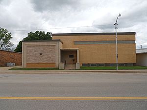
- Medford Bathhouse and Swimming Pool, Medford
See also
 In Spanish: Condado de Grant (Oklahoma) para niños
 | Roy Wilkins |
 | John Lewis |
 | Linda Carol Brown |


