Noble County, Oklahoma facts for kids
Quick facts for kids
Noble County
|
|
|---|---|

|
|

Location within the U.S. state of Oklahoma
|
|
 Oklahoma's location within the U.S. |
|
| Country | |
| State | |
| Founded | 1893 |
| Named for | John Willock Noble |
| Seat | Perry |
| Largest city | Perry |
| Area | |
| • Total | 743 sq mi (1,920 km2) |
| • Land | 732 sq mi (1,900 km2) |
| • Water | 11 sq mi (30 km2) 1.4%% |
| Population
(2020)
|
|
| • Total | 10,924 |
| • Density | 14.703/sq mi (5.677/km2) |
| Congressional district | 3rd |
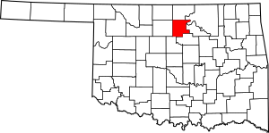
Noble County is a county located in the north central part of Oklahoma. In 2020, about 10,924 people lived there. Its main town, or county seat, is Perry.
The land that is now Noble County was once part of the Cherokee Outlet. This was a large area in Indian Territory. In 1890, it became part of Oklahoma Territory. The county was officially formed in 1893. It was named after John Willock Noble, who was the U.S. Secretary of the Interior at that time.
Contents
History of Noble County
For many years, the area of Noble County was a hunting ground for the Osage Indians. In 1835, a special agreement with the Cherokees made it part of the Cherokee Outlet.
During the time the Cherokees owned the land, cattle ranchers leased areas for grazing their animals. Later, parts of the county became special areas, called reservations, for the Otoe and Ponca tribes. These reservations existed until 1904. After that, the lands were divided up and became part of Noble County.
When the Oklahoma Organic Act was passed, the Cherokee Outlet became part of Oklahoma Territory. In 1893, the land was opened for new settlers. The town of Perry was started in August 1893. It became the county seat and a place where people could claim land.
In 1995, a person involved in a major event was arrested in Noble County. This person was stopped by a sheriff's deputy for a car violation. The officer, Charlie Hanger, later became the Noble County Sheriff in 2004.
In 2010, a large oil pipeline, the Keystone-Cushing Pipeline, was built through Noble County. It runs from north to south.
Geography of Noble County
Noble County covers about 743 square miles. Most of this is land, about 732 square miles. The rest, about 11 square miles, is water.
The Arkansas River forms part of the county's edge in the northeast. Two smaller rivers, Red Rock Creek in the north and Black Bear Creek in the south, flow through the county. They both empty into the Arkansas River.
Main Roads in Noble County
Many important roads cross Noble County. These roads help people travel and transport goods.
Neighboring Counties
Noble County shares borders with several other counties:
- Kay County (to the north)
- Osage County (to the northeast)
- Pawnee County (to the east)
- Payne County (to the south)
- Logan County (to the southwest)
- Garfield County (to the west)
People of Noble County (Demographics)
| Historical population | |||
|---|---|---|---|
| Census | Pop. | %± | |
| 1900 | 11,798 | — | |
| 1910 | 14,945 | 26.7% | |
| 1920 | 13,560 | −9.3% | |
| 1930 | 15,139 | 11.6% | |
| 1940 | 14,826 | −2.1% | |
| 1950 | 12,156 | −18.0% | |
| 1960 | 10,376 | −14.6% | |
| 1970 | 10,043 | −3.2% | |
| 1980 | 11,573 | 15.2% | |
| 1990 | 11,045 | −4.6% | |
| 2000 | 11,411 | 3.3% | |
| 2010 | 11,561 | 1.3% | |
| 2020 | 10,924 | −5.5% | |
| U.S. Decennial Census 1790-1960 1900-1990 1990-2000 2010 |
|||
In 2000, there were 11,411 people living in Noble County. There were 4,504 households, which are groups of people living together. The population density was about 6 people per square kilometer.
Most people in the county were White (86.44%). There were also Native American (7.57%), Black or African American (1.58%), and Asian (0.33%) residents. About 1.80% of the population was Hispanic or Latino.
About 32% of households had children under 18 living with them. The average household had 2.47 people. The average family had 2.97 people.
The median age in the county was 38 years old. This means half the people were younger than 38 and half were older. About 25.5% of the population was under 18.
The median income for a household was $33,968. This is the middle income level for all households. About 12.8% of the population lived below the poverty line.
Economy of Noble County
The economy of Noble County has mostly been based on farming and raising cattle. Wheat is the most important crop grown here. Other important crops include alfalfa, oats, corn, and barley.
The county is also part of an area rich in oil and natural gas. Natural gas wells started producing gas between 1915 and 1919. Oil production began in the 1920s.
A company called Ditch Witch has its main office in Perry, the county seat. This company makes equipment for digging trenches.
Towns and Cities
Noble County has several communities:
City
- Perry (This is the county seat, where the county government is located)
Towns
Census-designated places
These are areas that are like towns but are not officially incorporated as cities or towns.
Other Unincorporated Places
These are smaller communities that are not officially part of any city or town.
- Ceres
- Gansel
- Otoe
Historic Places (NRHP sites)
Several places in Noble County are listed on the National Register of Historic Places. This means they are important historical sites.
- First National Bank and Trust Company Building, Perry
- Morrison Baptist Church, Morrison
- Morrison Suspension Bridge, Morrison
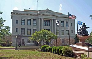
- Noble County Courthouse, Perry
- Perry Armory, Perry
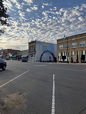
- Perry Courthouse Square Historic District, Perry
- Perry Lake Park, Perry
- Rein School, near Ponca City
- Renfrow Building, Billings
- Renfrow House, Billings
- Sumner School, Morrison
- Wolleson-Nicewander Building, Perry
See also
 In Spanish: Condado de Noble (Oklahoma) para niños
 | John T. Biggers |
 | Thomas Blackshear |
 | Mark Bradford |
 | Beverly Buchanan |


