Marland, Oklahoma facts for kids
Quick facts for kids
Marland, Oklahoma
|
|
|---|---|

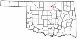
Location of Marland, Oklahoma
|
|
| Country | United States |
| State | Oklahoma |
| County | Noble |
| Government | |
| • Type | Elected City Council |
| Area | |
| • Total | 0.27 sq mi (0.70 km2) |
| • Land | 0.27 sq mi (0.70 km2) |
| • Water | 0.00 sq mi (0.00 km2) |
| Elevation | 1,020 ft (310 m) |
| Population
(2020)
|
|
| • Total | 184 |
| • Density | 676.47/sq mi (261.13/km2) |
| Time zone | UTC-6 (Central (CST)) |
| • Summer (DST) | UTC-5 (CDT) |
| ZIP code |
74644
|
| Area code(s) | 580 |
| FIPS code | 40-46550 |
| GNIS feature ID | 2412957 |
Marland is a small town located in Noble County, Oklahoma, in the United States. In 2010, the town had 225 people living there. It was named after Ernest W. Marland, who was an oilman from nearby Ponca City. Ernest Marland later became a governor of Oklahoma. Marland is found along SH-156, which is south of Ponca City.
History of Marland
Marland started as a community called "Bliss." It was a place where goods, especially cattle, were shipped by train. This area was once part of the Ponca Native American reservation. The land was rented out for cattle to graze. It was also part of the famous Miller Brothers 101 Ranch.
The Miller brothers built special pens next to the Atchison, Topeka and Santa Fe Railway tracks. These pens were used to load cattle onto trains. Soon, a small community grew around this shipping point. It had a place to store grain, a lumber yard, and a general store. In 1906, the Miller brothers planned out a town on the east side of the tracks and started selling plots of land.
In 1917, the Miller brothers decided to move the town. They moved it about 1 mile (1.6 km) north, to the other side of the train tracks. The town continued to grow, and its population reached 250 people.
During the 1920s, oil was discovered nearby by Ernest W. Marland. This oil discovery helped the town a lot. Because of this, the town held an election in April 1922 and changed its name to Marland. However, the Great Depression in the 1930s caused problems. The Miller Brothers ranch went bankrupt, and the oil fields dried up. This stopped the town from growing further.
Marland's Location and Size
Marland is a small town. According to the United States Census Bureau, the town covers a total area of about 0.3 square miles (0.78 square kilometers). All of this area is land, meaning there are no large lakes or rivers within the town limits.
Marland's Population Over Time
| Historical population | |||
|---|---|---|---|
| Census | Pop. | %± | |
| 1930 | 361 | — | |
| 1940 | 257 | −28.8% | |
| 1950 | 221 | −14.0% | |
| 1960 | 191 | −13.6% | |
| 1970 | 236 | 23.6% | |
| 1980 | 340 | 44.1% | |
| 1990 | 280 | −17.6% | |
| 2000 | 280 | 0.0% | |
| 2010 | 225 | −19.6% | |
| 2020 | 184 | −18.2% | |
| U.S. Decennial Census | |||
The number of people living in Marland has changed over the years. In 1930, there were 361 residents. By 2010, the population was 225. The most recent count in 2020 showed 184 people living in the town.
In 2000, there were 280 people living in Marland. These people lived in 83 different homes, and 65 of these were families. About 47% of the homes had children under 18 living there. Most homes (56.6%) were married couples living together.
The people in Marland were of different ages. About 41.4% of the population was under 18 years old. The average age in the town was 25 years. This means Marland had a relatively young population compared to some other places.
See also
In Spanish: Marland (Oklahoma) para niños
 | George Robert Carruthers |
 | Patricia Bath |
 | Jan Ernst Matzeliger |
 | Alexander Miles |

