
Reno County, Kansas facts for kids
Quick facts for kids
Reno County
|
|
|---|---|

Reno County Courthouse in Hutchinson (2008)
|
|

Location within the U.S. state of Kansas
|
|
 Kansas's location within the U.S. |
|
| Country | |
| State | |
| Founded | February 26, 1867 |
| Named for | Jesse Lee Reno |
| Seat | Hutchinson |
| Largest city | Hutchinson |
| Area | |
| • Total | 1,272 sq mi (3,290 km2) |
| • Land | 1,255 sq mi (3,250 km2) |
| • Water | 17 sq mi (40 km2) 1.3%% |
| Population
(2020)
|
|
| • Total | 61,898 |
| • Estimate
(2023)
|
61,497 |
| • Density | 49.3/sq mi (19.0/km2) |
| Time zone | UTC−6 (Central) |
| • Summer (DST) | UTC−5 (CDT) |
| Area code | 620 |
| Congressional district | 1st |
Reno County is a place in the state of Kansas, USA. It's like a big neighborhood or district. The main city and where the county government is located is Hutchinson. In 2020, about 61,898 people lived here. The county is named after Jesse Reno, who was a general during the American Civil War.
Contents
History of Reno County

Reno County has a long and interesting past. Before it became a county, this land was home to many different groups of people.
Who lived here first?
For thousands of years, the Great Plains region, where Reno County is, was home to Native American tribes. These groups often moved around, following animal herds and finding the best places to live.
How did the land become part of the USA?
In the 16th to 18th centuries, France claimed a lot of land in North America, including this area. Later, in 1762, France secretly gave this land to Spain.
Then, in 1802, Spain gave most of it back to France. But in 1803, the United States bought a huge amount of land from France. This was called the Louisiana Purchase. It was a very big deal, adding a lot to the USA!
When was Kansas formed?
In 1854, the area became the Kansas Territory. Then, in 1861, Kansas officially became the 34th U.S. state.
When was Reno County established?
Reno County was officially created in 1867. It was named after General Jesse L. Reno, who was a brave leader during the American Civil War.
How did railroads help Reno County grow?
In the late 1800s, railroads were super important for connecting towns and moving goods. In 1887, the Chicago, Kansas and Nebraska Railway built a main line through Reno County. This line connected Hutchinson to many other towns. Later, this railroad line became part of a famous route called the "Golden State Limited," which went all the way to El Paso, Texas.
Geography of Reno County
Reno County is a large area. It covers about 1,272 square miles. Most of this is land, but about 17 square miles are water, like rivers and lakes. It's the third-largest county in Kansas by size.
What counties are next to Reno County?
Reno County shares its borders with several other counties:
- Rice County (to the north)
- McPherson County (to the northeast)
- Harvey County (to the east)
- Sedgwick County (to the southeast)
- Kingman County (to the south)
- Pratt County (to the southwest)
- Stafford County (to the west)
Is there a special nature area in Reno County?
Yes, part of the Quivira National Wildlife Refuge is located in Reno County. This is a protected area where wildlife can live safely.
People of Reno County

The population of Reno County has changed over the years. In 1880, there were about 12,826 people. By 2020, the population had grown to 61,898.
What is the population like?
In 2000, there were about 64,790 people living in Reno County. Most people lived in families, and about 30% of households had children under 18. The average age of people in the county was 38 years old.
Education in Reno County
Reno County has several options for education, from colleges to local schools.
Colleges in Reno County
- Hutchinson Community College is a place where students can go after high school to continue their education.
Public Schools in Reno County
The county has several public school districts, which are groups of schools managed together:
- Hutchinson USD 308
- Nickerson-South Hutchinson USD 309
- Fairfield USD 310
- Pretty Prairie USD 311
- Haven USD 312
- Buhler USD 313
Private Schools in Hutchinson
There are also private schools in Hutchinson:
- Central Christian School (for students from kindergarten to 12th grade)
- Trinity Catholic High School (for students from 7th to 12th grade)
- Holy Cross Catholic School (for younger students from Pre-kindergarten to 6th grade)
Communities in Reno County

Reno County is made up of many different cities and smaller communities.
Cities in Reno County
- Abbyville
- Arlington
- Buhler
- Haven
- Hutchinson (This is the county seat, where the main government offices are)
- Langdon
- Nickerson
- Partridge
- Plevna
- Pretty Prairie
- South Hutchinson
- Sylvia
- The Highlands
- Turon
- Willowbrook
Smaller Communities (Unincorporated)
These places are not officially cities but are still communities:
- Castleton
- Darlow
- Huntsville
- Lerado
- Medora
- St. Joe
- Yaggy
- Yoder (This is also a Census-Designated Place, meaning the Census Bureau tracks it)
Townships in Reno County
Reno County is divided into 31 smaller areas called townships. Each township has its own population and land area. The cities of Hutchinson and Nickerson are counted separately and are not part of the township populations.
| Township | Population center |
Population | Land area km2 (sq mi) |
Water area km2 (sq mi) |
Water % |
|---|---|---|---|---|---|
| Albion | Pretty Prairie | 837 | 97 (38) | 0 (0) | 0.02% |
| Arlington | Arlington | 621 | 94 (36) | 0 (0) | 0.03% |
| Bell | 87 | 98 (38) | 0 (0) | 0.11% | |
| Castleton | 256 | 140 (54) | 0 (0) | 0.01% | |
| Center | Partridge | 672 | 94 (36) | 0 (0) | 0.17% |
| Clay | 3,302 | 88 (34) | 1 (0) | 0.58% | |
| Enterprise | 139 | 93 (36) | 0 (0) | 0.06% | |
| Grant | 1,307 | 114 (44) | 1 (1) | 1.25% | |
| Grove | 64 | 93 (36) | 0 (0) | 0.06% | |
| Haven | Haven | 1,592 | 143 (55) | 1 (0) | 0.41% |
| Hayes | 106 | 186 (72) | 0 (0) | 0.06% | |
| Huntsville | 118 | 93 (36) | 0 (0) | 0.11% | |
| Langdon | Langdon | 160 | 94 (36) | 0 (0) | 0.16% |
| Lincoln | 703 | 93 (36) | 0 (0) | 0.07% | |
| Little River | Buhler | 1,881 | 93 (36) | 1 (0) | 0.57% |
| Loda | 119 | 98 (38) | 0 (0) | 0.27% | |
| Medford | 144 | 83 (32) | 0 (0) | 0.18% | |
| Medora | 1,594 | 77 (30) | 0 (0) | 0% | |
| Miami | Turon | 521 | 98 (38) | 0 (0) | 0.15% |
| Ninnescah | 226 | 79 (31) | 27 (10) | 25.53% | |
| Plevna | Plevna | 235 | 94 (36) | 0 (0) | 0.04% |
| Reno | South Hutchinson | 4,496 | 90 (35) | 2 (1) | 1.65% |
| Roscoe | 108 | 98 (38) | 0 (0) | 0% | |
| Salt Creek | 483 | 139 (54) | 1 (0) | 0.39% | |
| Sumner | 547 | 106 (41) | 7 (3) | 6.13% | |
| Sylvia | Sylvia | 393 | 93 (36) | 0 (0) | 0.34% |
| Troy | 112 | 94 (36) | 0 (0) | 0.16% | |
| Valley | 887 | 143 (55) | 1 (0) | 0.90% | |
| Walnut | 114 | 94 (36) | 0 (0) | 0% | |
| Westminster | Abbyville | 243 | 94 (36) | 0 (0) | 0% |
| Yoder | 742 | 96 (37) | 1 (0) | 1.03% |
Images for kids
-
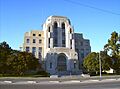
Reno County Courthouse in Hutchinson (2008)
-
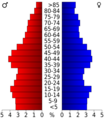
Population pyramid based on 2000 census age data
See also
 In Spanish: Condado de Reno para niños
