
Stafford County, Kansas facts for kids
Quick facts for kids
Stafford County
|
|
|---|---|

Stafford County Museum in Stafford (2017)
|
|

Location within the U.S. state of Kansas
|
|
 Kansas's location within the U.S. |
|
| Country | |
| State | |
| Founded | 1879 |
| Named for | Lewis Stafford |
| Seat | St. John |
| Largest city | St. John |
| Area | |
| • Total | 795 sq mi (2,060 km2) |
| • Land | 792 sq mi (2,050 km2) |
| • Water | 2.9 sq mi (8 km2) 0.4% |
| Population
(2020)
|
|
| • Total | 4,072 |
| • Density | 5.1/sq mi (2.0/km2) |
| Time zone | UTC−6 (Central) |
| • Summer (DST) | UTC−5 (CDT) |
| Congressional district | 4th |
Stafford County is a county located in the state of Kansas. The main town, or county seat, is St. John. In 2020, about 4,072 people lived here. The county is named after Lewis Stafford. He was a captain in the army who died during the American Civil War.
Contents
A Look Back: Stafford County's History
How Stafford County Began: The 1800s
The Kansas government first planned the borders of Stafford County in 1870. But for several years, the county wasn't officially set up. In 1875, the government tried to give parts of Stafford County to other nearby counties.
However, a small part of Stafford County was left over. Then, on April 25, 1879, the Supreme Court decided that the law dividing the county was not allowed. So, Stafford County got its original borders back and was officially organized in 1879.
Even with these legal issues, people started to settle in the area. W. R. Hoole was one of the first pioneers. He claimed land in May 1874. Soon after, John Birbeck built the first wooden house and started farming in 1875. The first baby born in the county was to W. R. Hoole and his wife in 1875.
There was a short attempt to make salt at Salt Marsh in 1876. But people soon found out the marsh was better for animals to graze.
A large group of Mormons also settled near St. John in 1875. This community, called Zion Valley, opened the county's first post office. They even built a temple. But disagreements caused the community to break up. The temple then became a regular business.
Education also started to grow. The first schoolhouse, called the Hoole Schoolhouse, was built in 1876. Miss Ella Miller was its first teacher.
In the early days, people in Stafford County made money by collecting buffalo bones. There were many bones scattered across the land. But this business didn't last long, as the bones were quickly picked up.
Geography: Where is Stafford County?
Stafford County covers about 795 square miles. Most of this area, about 792 square miles, is land. Only a small part, about 2.9 square miles, is water.
Neighboring Counties
Stafford County shares its borders with several other counties:
- Barton County (to the north)
- Rice County (to the northeast)
- Reno County (to the east)
- Pratt County (to the south)
- Edwards County (to the west)
- Pawnee County (also to the west)
Special Protected Areas
Part of the Quivira National Wildlife Refuge is located in Stafford County. This is a special place that protects wildlife and their homes.
People and Population: Who Lives Here?

| Historical population | |||
|---|---|---|---|
| Census | Pop. | %± | |
| 1880 | 4,755 | — | |
| 1890 | 7,520 | 58.1% | |
| 1900 | 9,829 | 30.7% | |
| 1910 | 12,510 | 27.3% | |
| 1920 | 11,559 | −7.6% | |
| 1930 | 10,460 | −9.5% | |
| 1940 | 10,487 | 0.3% | |
| 1950 | 8,816 | −15.9% | |
| 1960 | 7,451 | −15.5% | |
| 1970 | 5,943 | −20.2% | |
| 1980 | 5,694 | −4.2% | |
| 1990 | 5,365 | −5.8% | |
| 2000 | 4,789 | −10.7% | |
| 2010 | 4,437 | −7.4% | |
| 2020 | 4,072 | −8.2% | |
| 2023 (est.) | 3,909 | −11.9% | |
| U.S. Decennial Census 1790-1960 1900-1990 1990-2000 2010-2020 |
|||
In 2000, there were 4,789 people living in Stafford County. These people lived in 2,010 households. About 1,294 of these were families. The county had about 6 people per square mile.
Most people in the county were White (94.97%). A smaller number were Black (0.15%), Native American (0.38%), or Asian (0.13%). About 5.41% of the people were Hispanic or Latino.
About 29.90% of households had children under 18 living with them. More than half (55.90%) were married couples. About 33.00% of all households were single people. Also, 17.20% had someone living alone who was 65 or older.
The average age of people in the county was 41 years old. About 26.30% of the population was under 18. About 21.20% were 65 years or older. For every 100 females, there were about 95 males.
The average income for a household in the county was $31,107. For families, it was $38,235. About 11.80% of all people lived below the poverty line. This included 15.20% of those under 18.
Education: Schools in Stafford County
Students in Stafford County attend schools in different unified school districts. These districts bring together schools from several towns.
Local School Districts
- Stafford USD 349
- St. John-Hudson USD 350
- Macksville USD 351
Communities: Towns and Areas in Stafford County

Here is a list of the cities and other communities you can find in Stafford County.
Cities in Stafford County
Smaller Communities (Unincorporated)
These are smaller places that are not officially cities.
Townships: How the County is Divided
Stafford County is divided into 21 areas called townships. The cities within the county are part of these townships. So, the population numbers for the townships include the people living in the cities.
| Township | Population center |
Population | Land area km2 (sq mi) |
Water area km2 (sq mi) |
Geographic coordinates |
|---|---|---|---|---|---|
| Albano | 56 | 94 (36) | 0 (0) | 37°52′43″N 98°51′43″W / 37.87861°N 98.86194°W | |
| Byron | 80 | 94 (36) | 0 (0) | 38°12′50″N 98°38′7″W / 38.21389°N 98.63528°W | |
| Clear Creek | 36 | 93 (36) | 0 (0) | 37°50′57″N 98°57′31″W / 37.84917°N 98.95861°W | |
| Cleveland | 68 | 93 (36) | 0 (0) | 38°2′11″N 98°52′2″W / 38.03639°N 98.86722°W | |
| Douglas | 138 | 93 (36) | 0 (0) | 38°8′16″N 98°52′2″W / 38.13778°N 98.86722°W | |
| East Cooper | 90 | 92 (36) | 1 (0) | 38°2′43″N 98°31′6″W / 38.04528°N 98.51833°W | |
| Fairview | 98 | 93 (36) | 0 (0) | 37°56′52″N 98°31′4″W / 37.94778°N 98.51778°W | |
| Farmington | 591 | 93 (36) | 0 (0) | 37°57′30″N 98°58′2″W / 37.95833°N 98.96722°W | |
| Hayes | 212 | 93 (36) | 0 (0) | 38°7′20″N 98°38′49″W / 38.12222°N 98.64694°W | |
| Lincoln | 113 | 93 (36) | 0 (0) | 38°12′38″N 98°52′2″W / 38.21056°N 98.86722°W | |
| North Seward | 186 | 93 (36) | 0 (0) | 38°12′36″N 98°45′27″W / 38.21000°N 98.75750°W | |
| Ohio | 409 | 95 (36) | 0 (0) | 37°58′40″N 98°45′7″W / 37.97778°N 98.75194°W | |
| Putnam | 19 | 182 (70) | 5 (2) | 38°10′26″N 98°31′51″W / 38.17389°N 98.53083°W | |
| Richland | 70 | 94 (36) | 0 (0) | 37°57′49″N 98°51′12″W / 37.96361°N 98.85333°W | |
| Rose Valley | 74 | 94 (36) | 0 (0) | 37°51′41″N 98°44′19″W / 37.86139°N 98.73861°W | |
| St. John | 1,037 | 94 (36) | 0 (0) | 38°0′58″N 98°45′21″W / 38.01611°N 98.75583°W | |
| South Seward | 55 | 93 (36) | 0 (0) | 38°8′11″N 98°44′36″W / 38.13639°N 98.74333°W | |
| Stafford | 1,291 | 93 (36) | 0 (0) | 37°57′40″N 98°36′50″W / 37.96111°N 98.61389°W | |
| Union | 41 | 93 (36) | 0 (0) | 37°52′31″N 98°37′40″W / 37.87528°N 98.62778°W | |
| West Cooper | 64 | 93 (36) | 0 (0) | 38°2′37″N 98°38′9″W / 38.04361°N 98.63583°W | |
| York | 61 | 93 (36) | 0 (0) | 37°52′14″N 98°31′9″W / 37.87056°N 98.51917°W |
Images for kids
-
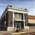
Stafford County Museum in Stafford (2017)
-
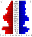
Population pyramid based on 2000 census age data
-
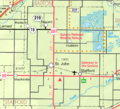
2005 map of Stafford County (map legend)
See also
 In Spanish: Condado de Stafford (Kansas) para niños
