
Barton County, Kansas facts for kids
Quick facts for kids
Barton County
|
|
|---|---|

Barton County Courthouse in Great Bend (1979)
|
|

Location within the U.S. state of Kansas
|
|
 Kansas's location within the U.S. |
|
| Country | |
| State | |
| Founded | February 26, 1867 |
| Named for | Clara Barton |
| Seat | Great Bend |
| Largest city | Great Bend |
| Area | |
| • Total | 901 sq mi (2,330 km2) |
| • Land | 895 sq mi (2,320 km2) |
| • Water | 5.2 sq mi (13 km2) 0.6%% |
| Population
(2020)
|
|
| • Total | 25,493 |
| • Density | 28.5/sq mi (11.0/km2) |
| Time zone | UTC−6 (Central) |
| • Summer (DST) | UTC−5 (CDT) |
| Area code | 620 |
| Congressional district | 1st |
Barton County is a county located in the state of Kansas. Its main city and county seat is Great Bend. As of the 2020 census, about 25,493 people lived here. The county is named after Clara Barton, who founded the American Red Cross. It's special because it's the only county in Kansas named after a woman!
Contents
History
Early Times
For thousands of years, the Great Plains of North America were home to nomadic Native American tribes. This means they moved around a lot instead of staying in one place.
Later, from the 16th to 18th centuries, France claimed large parts of North America. In 1762, after a big war, France secretly gave this land to Spain.
The 1800s
In 1802, Spain returned most of the land to France. Then, in 1803, the United States bought a huge area of land from France. This was called the Louisiana Purchase. It included most of what is now Kansas.
In 1854, the Kansas Territory was created. Then, in 1861, Kansas officially became the 34th U.S. state. Barton County itself was established in 1867. It was named after Clara Barton, a famous nurse who started the American Red Cross.
Railroads were very important in the 1800s. They helped people travel and move goods. In 1878, the Atchison, Topeka and Santa Fe Railway started building lines in the area. These lines connected towns like Florence, Marion, and Ellinwood. Over time, some of these old railway lines were closed or sold.
The 2000s
In 2001, a very strong tornado hit Hoisington. It was an F4 tornado, which means it was very powerful. This happened during the Hoisington High School's prom.
Geography
Barton County is shaped like a square, about 30 miles by 30 miles. It has a total area of about 901 square miles. Most of this is land, with only a small part (about 5.2 square miles) being water. The very center of the state of Kansas is actually located in Barton County!
Neighboring Counties
Barton County shares borders with these other counties:
- Ellis County (to the northwest)
- Russell County (to the north)
- Ellsworth County (to the northeast)
- Rice County (to the southeast)
- Stafford County (to the south)
- Pawnee County (to the southwest)
- Rush County (to the west)
Main Roads
These are some of the important highways that run through Barton County:
- U.S. Route 56
- U.S. Route 281
- Kansas Highway 4
- Kansas Highway 96
- Kansas Highway 156
Population Facts

The Great Bend Micropolitan Statistical Area includes all of Barton County. This means Great Bend is a central city for the surrounding area.
According to the 2000 census, there were 28,205 people living in Barton County. There were 11,393 households, which are groups of people living together. About 7,530 of these were families.
Most people in the county were White (about 93%). A smaller number were Black or African American, Native American, or Asian. About 8% of the population identified as Hispanic or Latino.
In terms of age, about 26% of the people were under 18 years old. About 18% were 65 years or older. The average age in the county was 39 years old.
Education
Colleges
- Barton Community College is a place where students can go to college after high school.
School Districts
Barton County has five main school districts. These districts work together for special education services through Barton County Special Services.
- Central Plains USD 112
- Ellinwood USD 355
- Great Bend USD 428
- Hoisington USD 431
- Otis-Bison USD 403 (This district also serves parts of Rush County)
Communities

Barton County has several cities and smaller communities.
Cities
- Albert
- Claflin
- Ellinwood
- Galatia
- Great Bend (This is the county seat, where the main government offices are.)
- Hoisington
- Olmitz
- Pawnee Rock
- Susank
Unincorporated Communities
These are smaller communities that are not officially cities. Some of them might also be partly in a neighboring county (‡) or are recognized as a "Census-Designated Place" by the government (†).
Townships
Barton County is divided into twenty-two smaller areas called townships. The cities of Ellinwood, Great Bend, and Hoisington are separate from these townships for census counting.
Images for kids
-
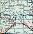
This map from 1915-1918 shows the railroad lines in Barton County.

See also
 In Spanish: Condado de Barton (Kansas) para niños
