Stickney, Kansas facts for kids
Quick facts for kids
Stickney, Kansas
|
|
|---|---|

|
|
| Country | United States |
| State | Kansas |
| County | Barton |
| Township | Wheatland |
| Elevation | 1,955 ft (596 m) |
| Time zone | UTC-6 (CST) |
| • Summer (DST) | UTC-5 (CDT) |
| ZIP code |
67544
|
| Area code | 620 |
| FIPS code | 20-68250 |
| GNIS ID | 484733 |
Stickney is a place in Barton County, Kansas, United States. It is an unincorporated area. This means it's not a town or city with its own local government. Instead, it's just a location. Stickney is known for having a grain elevator. However, no one lives there, and it's not a community.
History of Stickney
Stickney once had a post office. It opened in 1898. The post office helped people send and receive mail. It stayed open for about 15 years. It closed down in 1913.
Where is Stickney?
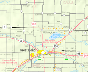
Stickney is located in Wheatland Township. It is about 1 mile (1.6 km) east of U.S. Route 281. This is a major highway. Stickney is also about 19 miles (31 km) north of Great Bend, Kansas. Great Bend is the main city in Barton County.
Stickney is near Sellens Creek. This creek flows into the Smoky Hill River. The area is part of the Smoky Hills region. This region is a part of the larger Great Plains.
Getting Around Stickney
Stickney is at a crossroads. It's where NW 190 Road meets NW 30 Avenue. NW 190 Road is a paved road that goes east and west. NW 30 Avenue is an unpaved road that goes north and south.
A long time ago, a train track ran through Stickney. This was part of the Atchison, Topeka and Santa Fe Railway. It was used to carry freight. But the train line is not there anymore.
 | Tommie Smith |
 | Simone Manuel |
 | Shani Davis |
 | Simone Biles |
 | Alice Coachman |


