Redwing, Kansas facts for kids
Quick facts for kids
Redwing, Kansas
|
|
|---|---|

|
|
| Country | United States |
| State | Kansas |
| County | Barton |
| Elevation | 1,811 ft (552 m) |
| Time zone | UTC-6 (CST) |
| • Summer (DST) | UTC-5 (CDT) |
| Area code | 620 |
| FIPS code | 20-58775 |
| GNIS ID | 475519 |
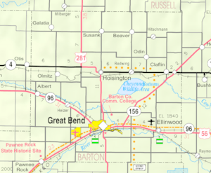
Redwing (sometimes spelled Red Wing) is a small place in Barton County, Kansas, United States. It is known as an "unincorporated community." This means it's a group of homes and buildings that are not part of an official city or town government. Instead, it's part of a larger area called Cheyenne Township.
Redwing is located about 1.5 miles (2.4 km) northwest of the edge of the Cheyenne Bottoms Wildlife Area. It is also 6 miles (9.7 km) east of the city of Hoisington and 7 miles (11.3 km) west of the city of Claflin.
A Look Back at Redwing
Redwing had its own post office for many years. It opened in 1892 and stayed in operation until 1955. This allowed people living in the community to send and receive mail easily.
In the past, Redwing was also home to a grain elevator. A grain elevator is a tall building used to store large amounts of grain, like wheat or corn. This suggests that farming was an important activity in the area around Redwing.
 | May Edward Chinn |
 | Rebecca Cole |
 | Alexa Canady |
 | Dorothy Lavinia Brown |


