
Cheyenne Bottoms facts for kids
Quick facts for kids Cheyenne Bottoms |
|
|---|---|

The Cheyenne Bottoms marshes are the largest wetland in the Great Plains.
|
|

Cheyenne Bottoms
Location in Kansas
|
|

A map of Barton County, Kansas
|
|
| Location | Barton County, Kansas |
| Coordinates | 38°28′10″N 98°39′21″W / 38.46944°N 98.65583°W |
| Type | Wetland |
| Primary inflows | Blood Creek, Deception Creek |
| Primary outflows | Little Cheyenne Creek |
| Basin countries | United States |
| Surface area | 64 sq mi (170 km2) |
| Average depth | 1 foot (0.30 m) |
| Max. depth | 4 feet (1.2 m) |
| Surface elevation | 1,795 feet (547 m) |
| Designated: | 19 October 1988 |
| Reference #: | 411 |
Cheyenne Bottoms is a huge wetland in the middle of North America. It covers about 41,000 acres (170 km2; 64 sq mi) in central Kansas. This makes it the biggest wetland in the central United States. Cheyenne Bottoms is a super important stop for millions of birds. These birds fly along the Central Flyway during their yearly migration.
Contents
History of Cheyenne Bottoms
Early Times and Legends
A legend says that in 1825, a battle happened here. The Cheyenne and Kiowa (or Pawnee) fought, and one stream turned red. Today, a stream called Blood Creek still flows into this area. Also, the sport of greyhound racing in the U.S. started here. The first event was a "coursing" race in 1886.
Protecting the Wetlands
In the early 1900s, people tried to change Cheyenne Bottoms. In 1900, a project called the Koen Ditch tried to bring water from the Arkansas River. The idea was to use this water to irrigate (water) crops. But a flood washed the ditch away.
Later, in the 1920s, some people wanted to drain the wetlands. They hoped to turn the land into farms. However, people living downstream in Hutchinson, Kansas worried. They protested, saying it would cause floods for them.
In 1925, the Kansas Forestry, Fish and Game Commission was created. Their job was to develop and care for Cheyenne Bottoms. In 1927, heavy rain turned the area into "Lake Cheyenne" overnight. This caused flooding downstream. Kansas politicians tried to get money from the government. They wanted to make it a National Wildlife Refuge, but they were not successful.
After 1937, new funds became available. These funds came from a tax on hunting gear. This money helped develop Cheyenne Bottoms.
Building and Managing the Area
By 1952, dikes (walls to hold water), roads, and hunting spots were built. Part of the area was then opened for public hunting. In 1957, a new canal was built from the Arkansas River. But not much water from the river reached the wetland. This was because of dry weather and other groups needing the water.
In the 1990s, the marshes were updated. This made them better at taking care of themselves. But getting enough water and managing water levels are still big challenges. Also in the 1990s, The Nature Conservancy started buying land next to the state wildlife area.
Geography of Cheyenne Bottoms
Cheyenne Bottoms is located in central Kansas. It sits in a low area of the Great Plains. The wetland is about 1,795 feet (547 m) above sea level.
Two small streams, Blood Creek and Deception Creek, flow into it. Another water source is a canal from Walnut Creek. The water then flows out through an outlet canal into Little Cheyenne Creek. This creek eventually joins the Arkansas River. Cheyenne Bottoms is entirely within Barton County.
The whole wetland covers about 41,000 acres (170 km2), or 64 square miles (170 km2). This makes it the largest wetland in the middle of the United States. A part of this area, 19,857 acres (80.36 km2), is called the Cheyenne Bottoms Wildlife Area.
The Bottoms has many pools of water. These pools are separated by dikes. Pool 1 is in the center, with other pools (2, 3A, 3B, 4A, 4B, and 5) around it.
Getting Around Cheyenne Bottoms
U.S. Route 281 runs about 2 miles (3.2 km) west of the Bottoms. Kansas Highway 4 is to the north. Kansas Highway 156 goes through the southeast part of the wetland. You can drive on unpaved gravel roads to explore the area. Some of these roads are on top of the dikes.
Geology of Cheyenne Bottoms
Scientists are still trying to fully understand how this wetland formed. It's a natural basin (a low, bowl-shaped area) in a dry region. The area is surrounded by bluffs up to 100 feet (30 m) high. These bluffs help trap the water from Blood and Deception Creeks.
One popular idea is that Cheyenne Bottoms formed like a giant sinkhole. This could have happened if fresh water dissolved underground salt. However, some experts disagree, saying there isn't enough salt in the ground for this.
Other ideas suggest that the ground moved, or that it was part of an ancient river system. Another theory is that sand dunes created the basin by moving sand and blocking water flow.
What Cheyenne Bottoms Looks Like
Historically, Cheyenne Bottoms has changed a lot. Sometimes it was a big lake, other times a muddy flat, or even completely dry. Today, it is carefully managed. This helps it stay a safe place for migrating birds.
The wildlife area has 5 main pools. These pools are crisscrossed by dikes and canals. The pools are usually less than one foot deep. Pools one and five are closed to people. Around the pools are mudflats, smaller ponds, and islands. Higher areas are mostly grasslands with a few trees. You can hunt waterfowl (like geese) along the southern edge of the wildlife area.
Wildlife at Cheyenne Bottoms
Cheyenne Bottoms is famous for the huge number of migratory shorebirds that visit. These birds come to feed on the muddy areas. During spring migration, up to 600,000 shorebirds from 39 different species pass through. In the fall, about 200,000 birds visit. About 45% of all shorebirds in North America use this area!
Cheyenne Bottoms is also a very important home for many endangered species. This includes the whooping crane, a very rare bird. Over 340 different kinds of birds have been seen here. Because it's so important for threatened and endangered birds, Cheyenne Bottoms is one of 29 places in the United States on the List of Ramsar wetlands of international importance. This means it's recognized globally for its importance.
Management of the Area
The main part of Cheyenne Bottoms, about 19,857 acres (80.36 km2), belongs to the Kansas Department of Wildlife, Parks and Tourism. The Nature Conservancy owns another 7,300 acres (30 km2) next to it. Both groups work together. They manage the land to create different marsh habitats. This helps support the many migrating and breeding waterfowl and shorebirds.
Visiting Cheyenne Bottoms
The Kansas Wetlands Education Center is located within the wildlife area. It teaches visitors about the wetlands and its animals. Around 60,000 people visit Cheyenne Bottoms every year.
In 2008, Cheyenne Bottoms and the Quivira National Wildlife Refuge were together named one of the "8 Wonders of Kansas."
Images for kids
-
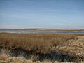
The Cheyenne Bottoms marshes are the largest wetland in the Great Plains.
-
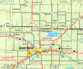
KDOT map of Barton County (legend)
