Pawnee County, Kansas facts for kids
Quick facts for kids
Pawnee County
|
|
|---|---|

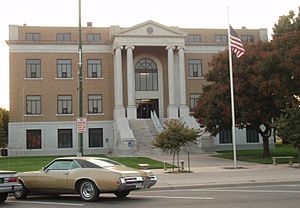
Pawnee County Courthouse in Larned (2009)
|
|

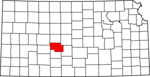
Location within the U.S. state of Kansas
|
|
 Kansas's location within the U.S. |
|
| Country | |
| State | |
| Founded | February 26, 1867 |
| Named for | Pawnee tribe |
| Seat | Larned |
| Largest city | Larned |
| Area | |
| • Total | 755 sq mi (1,960 km2) |
| • Land | 754 sq mi (1,950 km2) |
| • Water | 0.4 sq mi (1 km2) 0.05%% |
| Population
(2020)
|
|
| • Total | 6,253 |
| • Density | 8.3/sq mi (3.2/km2) |
| Time zone | UTC−6 (Central) |
| • Summer (DST) | UTC−5 (CDT) |
| Congressional districts | 1st, 4th |
Pawnee County is a county located in the state of Kansas. Its main city and county seat is Larned. In 2020, about 6,253 people lived here. The county gets its name from the Pawnee tribe, a Native American group who used to live in this area. Pawnee County is known for its farming, especially for growing winter wheat.
Contents
Economy in Pawnee County
Farming is super important in Pawnee County! It's one of the top places in Kansas for growing winter wheat. Farmers also grow other crops like oilseed, grains, vegetables, melons, and cotton. Plus, many people here raise beef cattle.
History of Pawnee County
Pawnee County was officially created in 1867. It's named after the Pawnee Native American tribe, who lived in this region a long time ago. Before it became Pawnee County, this area was part of other counties like Washington, Peketon, and Marion.
Fort Larned and the Santa Fe Trail
A place called Fort Larned was built near where Larned, Kansas is today, between 1859 and 1860. Its main job was to protect wagon trains traveling on the Santa Fe Trail, a famous old route.
In 1863, a group of Cheyenne and Arapaho Native Americans, who were very hungry, stopped a wagon train. When their request for supplies was refused, they attacked the wagon train. Only one person survived and found safety at Fort Larned.
Because of these growing tensions, Fort Larned became a key base for Major General Winfield Scott Hancock's efforts to deal with the Plains tribes. He asked for help from the U.S. Seventh Cavalry, led by Lieutenant Colonel George Armstrong Custer. Custer's actions against the Cheyenne eventually led to their defeat in the Battle of the Washita River in Oklahoma.
Fort Larned also helped protect workers building railroads. It gave out supplies promised to Native Americans by treaties and served as an office for the Bureau of Indian Affairs in the 1860s. The fort officially closed in 1878, but a small group of soldiers stayed there until 1883.
Geography of Pawnee County
Pawnee County covers about 755 square miles. Most of this area is land (754 square miles), with a very small amount of water (0.4 square miles).
Neighboring Counties
Pawnee County shares borders with these other counties:
- Rush County (to the north)
- Barton County (to the northeast)
- Stafford County (to the east)
- Edwards County (to the south)
- Hodgeman County (to the west)
- Ness County (to the northwest)
Protected Areas
- Fort Larned National Historic Site is a special protected area in the county.
People of Pawnee County (Demographics)
In 2000, there were 7,233 people living in Pawnee County. The population density was about 10 people per square mile. Most people in the county were White (about 91%). About 5% were Black or African American, and about 4% were Hispanic or Latino.
The median age in the county was 40 years old. This means half the people were younger than 40 and half were older. About 24% of the population was under 18 years old.
Education in Pawnee County
Pawnee County has two main school districts:
- Ft. Larned USD 495
- Pawnee Heights USD 496
Communities in Pawnee County
Here are the cities and towns in Pawnee County:
Cities
Unincorporated Communities
These are smaller towns or areas that don't have their own city government:
- Ash Valley
- Frizell
- Sanford
- Zook
Images for kids
See also
 In Spanish: Condado de Pawnee (Kansas) para niños
 | Laphonza Butler |
 | Daisy Bates |
 | Elizabeth Piper Ensley |


