Larned, Kansas facts for kids
Quick facts for kids
Larned, Kansas
|
|
|---|---|
|
City and County seat
|
|

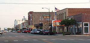
Business District (2009)
|
|

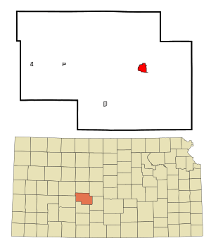
Location within Pawnee County and Kansas
|
|

|
|
| Country | United States |
| State | Kansas |
| County | Pawnee |
| Founded | 1870s |
| Platted | 1873 |
| Incorporated | 1886 |
| Named for | Fort Larned |
| Area | |
| • Total | 2.41 sq mi (6.24 km2) |
| • Land | 2.41 sq mi (6.24 km2) |
| • Water | 0.00 sq mi (0.00 km2) |
| Elevation | 2,034 ft (620 m) |
| Population
(2020)
|
|
| • Total | 3,769 |
| • Density | 1,564/sq mi (604.0/km2) |
| Time zone | UTC-6 (CST) |
| • Summer (DST) | UTC-5 (CDT) |
| ZIP code |
67550
|
| Area code | 620 |
| FIPS code | 20-38700 |
| GNIS ID | 485608 |
Larned is a city located in the state of Kansas, United States. It is the main city and county seat of Pawnee County, Kansas. In 2020, about 3,769 people lived there.
Contents
Discover Larned's Past
Larned was first planned out in 1873. This means people decided where streets and buildings would go. The first post office in Larned opened in 1872, helping people send and receive mail.
The city got its name from a nearby place called Fort Larned. This fort was important from 1859 to 1878. It was named after Colonel Benjamin Larned, who was a paymaster in the U.S. Army.
Larned's Location and Climate
Larned is a city that covers about 2.39 square miles (6.2 square kilometers) of land. There is no water area within the city limits.
Larned's Weather Patterns
The weather in Larned has hot and humid summers. Winters are usually mild to cool. Larned has what is called a humid subtropical climate. This means it gets a lot of rain, especially in summer, and has warm temperatures for most of the year.
| Climate data for Larned, Kansas, 1991–2020 normals, extremes 1904–present | |||||||||||||
|---|---|---|---|---|---|---|---|---|---|---|---|---|---|
| Month | Jan | Feb | Mar | Apr | May | Jun | Jul | Aug | Sep | Oct | Nov | Dec | Year |
| Record high °F (°C) | 82 (28) |
89 (32) |
97 (36) |
101 (38) |
104 (40) |
112 (44) |
114 (46) |
114 (46) |
108 (42) |
99 (37) |
90 (32) |
82 (28) |
114 (46) |
| Mean maximum °F (°C) | 68.8 (20.4) |
74.4 (23.6) |
82.3 (27.9) |
89.9 (32.2) |
95.0 (35.0) |
100.3 (37.9) |
104.2 (40.1) |
102.4 (39.1) |
99.2 (37.3) |
91.2 (32.9) |
78.1 (25.6) |
66.9 (19.4) |
105.4 (40.8) |
| Mean daily maximum °F (°C) | 43.9 (6.6) |
47.3 (8.5) |
57.5 (14.2) |
66.5 (19.2) |
75.8 (24.3) |
85.9 (29.9) |
91.1 (32.8) |
89.6 (32.0) |
82.4 (28.0) |
69.3 (20.7) |
55.6 (13.1) |
44.5 (6.9) |
67.5 (19.7) |
| Daily mean °F (°C) | 32.4 (0.2) |
35.6 (2.0) |
45.3 (7.4) |
53.5 (11.9) |
63.9 (17.7) |
74.4 (23.6) |
79.3 (26.3) |
77.7 (25.4) |
70.0 (21.1) |
57.0 (13.9) |
43.8 (6.6) |
34.2 (1.2) |
55.6 (13.1) |
| Mean daily minimum °F (°C) | 20.9 (−6.2) |
23.9 (−4.5) |
33.1 (0.6) |
40.4 (4.7) |
52.0 (11.1) |
62.8 (17.1) |
67.4 (19.7) |
65.7 (18.7) |
57.6 (14.2) |
44.7 (7.1) |
32.0 (0.0) |
23.9 (−4.5) |
43.7 (6.5) |
| Mean minimum °F (°C) | 3.3 (−15.9) |
6.4 (−14.2) |
14.3 (−9.8) |
26.4 (−3.1) |
37.5 (3.1) |
51.6 (10.9) |
58.2 (14.6) |
55.7 (13.2) |
42.6 (5.9) |
27.3 (−2.6) |
15.0 (−9.4) |
7.1 (−13.8) |
−1.1 (−18.4) |
| Record low °F (°C) | −22 (−30) |
−24 (−31) |
−20 (−29) |
10 (−12) |
16 (−9) |
38 (3) |
44 (7) |
39 (4) |
26 (−3) |
13 (−11) |
−4 (−20) |
−22 (−30) |
−24 (−31) |
| Average precipitation inches (mm) | 0.67 (17) |
0.93 (24) |
1.74 (44) |
2.20 (56) |
4.11 (104) |
4.21 (107) |
3.88 (99) |
3.61 (92) |
1.82 (46) |
2.08 (53) |
0.99 (25) |
1.00 (25) |
27.24 (692) |
| Average snowfall inches (cm) | 5.1 (13) |
2.8 (7.1) |
2.7 (6.9) |
0.6 (1.5) |
0.0 (0.0) |
0.0 (0.0) |
0.0 (0.0) |
0.0 (0.0) |
0.0 (0.0) |
0.1 (0.25) |
0.3 (0.76) |
3.1 (7.9) |
14.7 (37.41) |
| Average precipitation days (≥ 0.01 in) | 2.7 | 3.1 | 4.9 | 5.8 | 7.6 | 7.1 | 7.7 | 6.7 | 4.3 | 4.8 | 3.3 | 3.2 | 61.2 |
| Average snowy days (≥ 0.1 in) | 1.6 | 1.4 | 1.0 | 0.3 | 0.0 | 0.0 | 0.0 | 0.0 | 0.0 | 0.0 | 0.2 | 1.7 | 6.2 |
| Source: NOAA (snow/snow days 1981–2010) | |||||||||||||
Larned's Population and People
| Historical population | |||
|---|---|---|---|
| Census | Pop. | %± | |
| 1880 | 1,066 | — | |
| 1890 | 1,861 | 74.6% | |
| 1900 | 1,583 | −14.9% | |
| 1910 | 2,911 | 83.9% | |
| 1920 | 3,139 | 7.8% | |
| 1930 | 3,532 | 12.5% | |
| 1940 | 3,533 | 0.0% | |
| 1950 | 4,447 | 25.9% | |
| 1960 | 5,001 | 12.5% | |
| 1970 | 4,567 | −8.7% | |
| 1980 | 4,811 | 5.3% | |
| 1990 | 4,490 | −6.7% | |
| 2000 | 4,236 | −5.7% | |
| 2010 | 4,054 | −4.3% | |
| 2020 | 3,769 | −7.0% | |
| U.S. Decennial Census | |||
How Many People Live in Larned?
In 2020, the census counted 3,769 people living in Larned. There were 1,704 households, which are groups of people living together in one home. The population density was about 1,564 people per square mile.
Most people in Larned (about 85.8%) are white. About 2.4% are black, and smaller groups are Native American, Asian, or Pacific Islander. About 8.5% of the population is Hispanic or Latino.
About 26.3% of households had children under 18. Many households (39.2%) were married couples. The average household had 2 people, and families had about 2.8 people. The median age in Larned was 42.6 years old. This means half the people were younger and half were older than 42.6.
Larned's Population in 2010
The census in 2010 showed that 4,054 people lived in Larned. There were 1,824 households. The city had about 1,696 people per square mile.
Most people (92.2%) were white. About 2.7% were African American. Around 7% of the people were Hispanic or Latino.
About 27% of households had children under 18. The average household size was 2.18 people. The median age was 42.7 years. About 23.9% of residents were under 18, and 19.7% were 65 or older.
Learning in Larned
The local public schools in Larned are part of the Fort Larned USD 495 school district. This district helps students get a good education.
Larned in the News
The local newspaper for Larned is called Larned Tiller & Toiler. It shares news and stories about the community.
What Drives Larned's Economy?
Larned has several important places that help its economy:
- Fort Larned USD 495: This is the local school district, which provides jobs and services.
- Larned State Hospital: Located west of Larned, this hospital is a major employer.
- Larned Correctional Mental Health Facility: Also west of Larned, this facility provides jobs and services.
Fun Places to Visit in Larned
- Santa Fe Trail Center: This museum is all about the history of the Santa Fe Trail. It's a great place to learn about the past.
- Fort Larned National Historic Site: This historic fort is about 5.5 miles (8.9 km) west of Larned. You can explore its old buildings and learn about its role in history.
Famous People from Larned
Many interesting people have come from Larned:
- Belle Jennings Benchley: Known as "the Zoo lady," she was a director of the San Diego Zoo.
- Gene Keady: A well-known Big Ten sportscaster and former basketball coach for the Purdue Boilermakers men's basketball team.
- Hal Patterson: A former professional football player and member of the Canadian Football Hall of Fame.
- Glee S. Smith, Jr.: A former Kansas state politician and lawyer.
- Ralph Terry: A retired pitcher for the New York Yankees who won two World Series. He was also a professional golfer.
- Mitch Webster: A retired Major League Baseball outfielder.
- John Zook: A former football player who played for the University of Kansas and in the NFL.
See also
 In Spanish: Larned para niños
 | Emma Amos |
 | Edward Mitchell Bannister |
 | Larry D. Alexander |
 | Ernie Barnes |

