
Ness County, Kansas facts for kids
Quick facts for kids
Ness County
|
|
|---|---|

Ness County Courthouse in Ness City (2016)
|
|

Location within the U.S. state of Kansas
|
|
 Kansas's location within the U.S. |
|
| Country | |
| State | |
| Founded | February 26, 1867 |
| Named for | Noah V. Ness |
| Seat | Ness City |
| Largest city | Ness City |
| Area | |
| • Total | 1,075 sq mi (2,780 km2) |
| • Land | 1,075 sq mi (2,780 km2) |
| • Water | 0.3 sq mi (0.8 km2) 0.02%% |
| Population
(2020)
|
|
| • Total | 2,687 |
| • Density | 2.5/sq mi (1.0/km2) |
| Time zone | UTC−6 (Central) |
| • Summer (DST) | UTC−5 (CDT) |
| Congressional district | 1st |
Ness County is a place in the state of Kansas, USA. It's like a big neighborhood with its own main town, called Ness City. Ness City is both the biggest town and where the county's government offices are. In 2020, about 2,687 people lived here. The county got its name from Noah Ness, who was a soldier in the 7th Kansas Cavalry.
Contents
History of Ness County
Ness County was officially created on February 26, 1867. That same year, a conflict happened here between the Cheyenne and Sioux tribes and General Winfield Scott Hancock. This event took place at the Indian Village on Pawnee Fork.
The county was first set up in 1873, but it was disorganized a year later. It was officially reorganized on April 14, 1880. Ness City, the county seat, was founded soon after the county was first created.
Ross Calhoun, often called the "Father of Ness City," arrived around 1877 or 1878. He opened the first general store and officially planned out the town in October 1878. He invited new settlers to join him.
From 1880 to 1883, there was a big fight over which town would be the county seat. Ness City, Sidney, and Clarinda all wanted the title. There were even claims of cheating and dishonest actions. In the end, Ness City was confirmed as the official county seat.
Geography of Ness County
Ness County is located in the state of Kansas. The U.S. Census Bureau says the county covers a total area of about 1,075 square miles. Almost all of this area is land, with only a tiny bit (0.02%) being water.
Counties Next to Ness County
Ness County shares its borders with several other counties:
- Trego County (to the north)
- Ellis County (to the northeast)
- Rush County (to the east)
- Pawnee County (to the southeast)
- Hodgeman County (to the south)
- Finney County (to the southwest)
- Lane County (to the west)
- Gove County (to the northwest)
People in Ness County (Demographics)
The number of people living in Ness County has changed over the years.
- In 1880, there were 3,722 people.
- By 1920, the population grew to 7,490.
- In 1950, it was 6,322.
- By 2000, the population was 3,454.
- In the 2020 census, the population was 2,687.
The average age of people in the county in 2000 was 44 years old. About 22.9% of the population was under 18 years old.
Education in Ness County
Students in Ness County attend schools that are part of unified school districts. These districts manage the public schools in the area.
School Districts
- Western Plains USD 106
- Ness City USD 303
Some students might also attend schools in a district that has offices in a nearby county:
- La Crosse USD 395
Communities in Ness County

Ness County has several cities and smaller communities. The county is also divided into areas called townships.
Cities in Ness County
- Bazine
- Brownell
- Ness City (This is the county seat, meaning it's where the main government offices are.)
- Ransom
- Utica
Unincorporated Communities
These are smaller communities that are not officially organized as cities.
Ghost Towns
A ghost town is a place that used to be a community but is now mostly empty or abandoned.
Images for kids
-
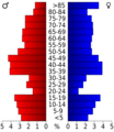
This chart shows the age groups of people in Ness County based on the 2000 census.

See also
 In Spanish: Condado de Ness para niños
