
Trego County, Kansas facts for kids
Quick facts for kids
Trego County
|
|
|---|---|

Trego County Courthouse in WaKeeney (2017)
|
|

Location within the U.S. state of Kansas
|
|
 Kansas's location within the U.S. |
|
| Country | |
| State | |
| Founded | June 21, 1879 |
| Named for | Edgar Poe Trego |
| Seat | WaKeeney |
| Largest city | WaKeeney |
| Area | |
| • Total | 900 sq mi (2,000 km2) |
| • Land | 889 sq mi (2,300 km2) |
| • Water | 10 sq mi (30 km2) 1.1% |
| Population
(2020)
|
|
| • Total | 2,808 |
| • Density | 3.2/sq mi (1.2/km2) |
| Time zone | UTC−6 (Central) |
| • Summer (DST) | UTC−5 (CDT) |
| Congressional district | 1st |
Trego County is a county located in the state of Kansas in the United States. Its most important city and the place where the county government is located is WaKeeney. This city is also the largest in the county. In 2020, about 2,808 people lived in Trego County. The county was named after a person named Edgar Trego.
Contents
History of Trego County
Early Days and Land Changes
For thousands of years, the Great Plains of North America were home to nomadic Native American groups. These groups moved around to hunt and find food.
From the 1500s to the 1700s, the Kingdom of France said it owned large parts of North America. In 1762, after a big war called the French and Indian War, France secretly gave a huge area of land, known as New France, to Spain. This was part of a deal called the Treaty of Fontainebleau.
How Kansas Became a State
In 1802, Spain gave most of this land back to France. However, Spain kept about 7,500 square miles for itself. Then, in 1803, the United States bought a very large area of land from France. This was called the Louisiana Purchase. Most of the land that is now Kansas was part of this huge purchase. The United States paid about 2.83 cents for each acre of land.
In 1854, the area was officially set up as the Kansas Territory. Later, in 1861, Kansas became the 34th U.S. state. Finally, in 1879, Trego County was officially created.
Geography of Trego County
Trego County covers a total area of about 900 square miles. Most of this area, about 889 square miles, is land. The rest, about 10 square miles, is water. This means that about 1.1% of the county's total area is water.
Neighboring Counties
Trego County shares its borders with several other counties:
- Graham County to the north
- Rooks County to the northeast
- Ellis County to the east
- Ness County to the south
- Gove County to the west
Main Roads in Trego County
These are the most important roads that go through Trego County:
 Interstate 70
 U.S. Route 40
 U.S. Route 283
 K-147
K-147
People of Trego County

| Historical population | |||
|---|---|---|---|
| Census | Pop. | %± | |
| 1870 | 166 | — | |
| 1880 | 2,535 | 1,427.1% | |
| 1890 | 2,535 | 0.0% | |
| 1900 | 2,722 | 7.4% | |
| 1910 | 5,398 | 98.3% | |
| 1920 | 5,880 | 8.9% | |
| 1930 | 6,470 | 10.0% | |
| 1940 | 5,822 | −10.0% | |
| 1950 | 5,868 | 0.8% | |
| 1960 | 5,473 | −6.7% | |
| 1970 | 4,436 | −18.9% | |
| 1980 | 4,165 | −6.1% | |
| 1990 | 3,694 | −11.3% | |
| 2000 | 3,319 | −10.2% | |
| 2010 | 3,001 | −9.6% | |
| 2020 | 2,808 | −6.4% | |
| 2023 (est.) | 2,731 | −9.0% | |
| U.S. Decennial Census 1790-1960 1900-1990 1990-2000 2010-2020 |
|||
In 2000, there were 3,319 people living in Trego County. The population density was about 4 people for every square mile. This means the county is not very crowded. There were 1,412 homes, with many of them being married couples living together.
About 27.3% of the homes had children under 18 years old. The average home had about 2.27 people. Many people living alone were 65 years old or older.
The population of the county is spread out across different age groups. About 23.9% of the people were under 18 years old. About 24% of the people were 65 years or older. The average age in the county was 44 years old. For every 100 females, there were about 91 males.
Education in Trego County
School Districts
The main school district in Trego County is:
- WaKeeney USD 208
Communities in Trego County

Trego County has several different types of communities. Some are cities, some are smaller places not officially part of a city, and some are "ghost towns" that no longer exist.
Cities
Unincorporated Communities
These are smaller towns or villages that are not officially organized as cities.
Ghost Towns
These are places where towns used to be, but now very few or no people live there.
- Banner
- Bosna
- Cyrus
- Wilcox
Townships
Trego County is divided into seven smaller areas called townships. These townships help organize the county. The cities within the county are part of these townships.
Images for kids
-
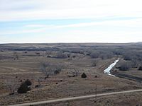
The Smoky Hill River valley, located east of the Cedar Bluff Reservoir dam.
-
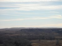
The Fort Hays escarpment, a steep slope of land, southeast of the Cedar Bluff Reservoir dam.


See also
 In Spanish: Condado de Trego para niños
