Cedar Bluff Reservoir facts for kids
Quick facts for kids Cedar Bluff Reservoir |
|
|---|---|
 |
|

|
|
| Location | Trego County, Kansas |
| Coordinates | 38°47′10.88″N 99°46′42.30″W / 38.7863556°N 99.7784167°W |
| Type | Reservoir |
| Primary inflows | Smoky Hill River |
| Primary outflows | Smoky Hill River |
| Catchment area | 5,365 sq mi (13,900 km2) |
| Basin countries | United States |
| Managing agency | U.S. Bureau of Reclamation |
| Built | April 1, 1949 |
| First flooded | September 29, 1951 |
| Max. length | 9 miles (14 km) |
| Surface area | 6,869 acres (27.80 km2) |
| Max. depth | 42 ft (13 m) |
| Water volume | Full: 172,452 acre⋅ft (212,716,000 m3) Current (Nov. 2015): 55,329 acre⋅ft (68,247,000 m3) |
| Shore length1 | 50 mi (80 km) |
| Surface elevation | Full: 2,144 ft (653 m) Current (Nov. 2015): 2,119 ft (646 m) |
| Settlements | Brownell, Ogallah |
| 1 Shore length is not a well-defined measure. | |
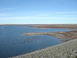
Cedar Bluff Reservoir is a large, human-made lake in Trego County, Kansas, United States. It was built by the U.S. Bureau of Reclamation to help with irrigation and provide water to the area. Today, it's also used to control floods and is a popular spot for fun outdoor activities. You can find Cedar Bluff State Park right on its shores.
Contents
Building Cedar Bluff Reservoir
Why Was It Built?
In the 1930s, western Kansas faced a very bad dry period called the Dust Bowl. This made people realize they needed better ways to water their farms and get drinking water. So, in 1941, the U.S. Bureau of Reclamation started looking into building a reservoir on the Smoky Hill River.
Construction and First Uses
Work on Cedar Bluff Dam and the reservoir began on April 1, 1949. It took over two years to finish, wrapping up on September 29, 1951. At first, it was hard to set up a system to deliver water to farms. But in 1958, the Cedar Bluff Irrigation District was finally formed.
A long canal, about 18-mile (29 km) long, was built from 1961 to 1963 to carry water for irrigation. In 1963, the city of Russell, Kansas also started using water from the reservoir for its homes and businesses.
Fish Hatchery and Changes
In 1959, a fish hatchery was built near the dam. This hatchery used water from the reservoir to raise fish. These fish were then released into lakes and rivers in Kansas and nearby states like Colorado, Oklahoma, and Texas.
Why Irrigation Stopped
Starting in the late 1960s, the amount of water flowing in the Smoky Hill River dropped a lot. This was probably because more water was being pumped from underground and because of high evaporation rates. Because of this, using the reservoir for irrigation stopped in 1978. The canal was closed down.
The fish hatchery also closed in 1983. It was later used to raise Canada geese. The irrigation district officially ended in 1994. Now, the Kansas Water Office and the Kansas Department of Wildlife, Parks and Tourism help manage the reservoir.
What It's Used For Today
Since irrigation stopped, Cedar Bluff Reservoir is mostly used for fun activities like boating and fishing. The Kansas Department of Wildlife and Parks oversees these activities. The U.S. Bureau of Reclamation still manages the reservoir for flood control and to provide drinking water.
Where is Cedar Bluff Reservoir?
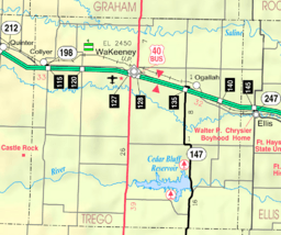
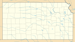
Cedar Bluff Reservoir is located in west-central Kansas. It sits in the Smoky Hills area, which is part of the larger Great Plains. The entire reservoir is within Trego County.
The Dam and River
The reservoir is held back on its eastern side by the Cedar Bluff Dam. The Smoky Hill River flows into the reservoir from the west and then flows out of it to the east. Smaller streams like Cedar Gorge and Page Creek also feed into the reservoir.
Kansas Highway 147 runs along the eastern side of the reservoir and goes right over the top of the dam.
How Big is the Reservoir?
The size of Cedar Bluff Reservoir can change depending on how much water flows in and how much rain falls. When it's full, the reservoir covers about 6,869 acres (27.80 km2) of land. Its deepest point is about 42 feet (13 m) deep.
The bottom of the reservoir has slowly gotten higher over time. This is because dirt and other materials have settled there since the reservoir was first filled.
Managing the Reservoir
The U.S. Bureau of Reclamation is in charge of running and taking care of both the dam and the reservoir. The U.S. Army Corps of Engineers also helps by providing information about managing water to prevent floods.
The Kansas Department of Wildlife, Parks and Tourism (KDWP) manages a large area of land around the reservoir, about 9,300 acres (38 km2). This area is known as the Cedar Bluff Wildlife Area.
Fun at Cedar Bluff Reservoir
Cedar Bluff State Park
The KDWP runs Cedar Bluff State Park, which is located on the eastern side of the reservoir. The park has two main parts:
- The Bluffton Area on the north shore, which is about 350-acre (1.4 km2).
- The Page Creek Area on the south shore, which is about 500-acre (2.0 km2).
Both areas have places to launch boats and camp. The Bluffton Area also has a swimming beach and sports fields.
Activities
You can go fishing in Cedar Bluff Reservoir all year round. Hunting is also allowed on the public land around the reservoir, but there are some restricted spots.
Cool Places to See
- Threshing Machine Canyon: West of the park, this canyon is where a wagon train carrying a threshing machine was attacked by American Indians in 1867. You can still see carvings on the canyon walls from the mid-1800s.
- Cedar Bluff: On the south shore of the reservoir's western end, you'll find the 150-foot (46 m) tall limestone bluff that gave the reservoir its name. It offers amazing views of the area.
Wildlife Around the Reservoir
Fish
Many types of fish live in Cedar Bluff Reservoir, including:
Animals and Birds
You can also find various animals living around the reservoir, such as:
Birds like Doves, ducks, and geese fly through the area during different seasons. In winter, you might even spot Bald eagles and golden eagles visiting.
Images for kids
 | Dorothy Vaughan |
 | Charles Henry Turner |
 | Hildrus Poindexter |
 | Henry Cecil McBay |


