
Hodgeman County, Kansas facts for kids
Quick facts for kids
Hodgeman County
|
|
|---|---|
_from_W_2.JPG)
Hodgeman County Courthouse in Jetmore (2016)
|
|

Location within the U.S. state of Kansas
|
|
 Kansas's location within the U.S. |
|
| Country | |
| State | |
| Founded | February 26, 1867 |
| Named for | Amos Hodgman |
| Seat | Jetmore |
| Largest city | Jetmore |
| Area | |
| • Total | 860 sq mi (2,200 km2) |
| • Land | 860 sq mi (2,200 km2) |
| • Water | 0.3 sq mi (0.8 km2) 0.04%% |
| Population
(2020)
|
|
| • Total | 1,723 |
| • Estimate
(2021)
|
1,710 |
| • Density | 2.0/sq mi (0.8/km2) |
| Time zone | UTC−6 (Central) |
| • Summer (DST) | UTC−5 (CDT) |
| Congressional district | 1st |
Hodgeman County is a county in the state of Kansas. A county is like a smaller region within a state, often with its own local government. The main town and biggest city in Hodgeman County is Jetmore. In 2020, about 1,723 people lived here. The county was named after Amos Hodgman, who was a member of the 7th Regiment Kansas Volunteer Cavalry.
Contents
History of Hodgeman County
Hodgeman County was created on February 26, 1867. It was named after Amos Hodgman, a soldier from the 7th Regiment Kansas Volunteer Cavalry. Later, an "E" was added to his last name when the county was officially named. The county didn't have its own formal government until 1879.
In the late 1870s, many people moved to this area because of the Homestead Act of 1862. This law allowed settlers to claim land if they lived on it and farmed it. Farmers started planting wheat, and their crops grew well by 1878.
At first, several small towns in the county wanted to be the main county seat. Buckner, which is now called Jetmore, eventually won this important role. Many small towns like Kidderville and Milroy started up, but only Jetmore and Hanston grew into lasting communities. By the late 1870s, about 1,500 people lived in Hodgeman County.
Geography
Hodgeman County covers about 860 square miles (2,227 square kilometers). Most of this area is land, with only a tiny bit of water.
Neighboring Counties
Hodgeman County shares its borders with these other counties:
- Ness County (to the north)
- Pawnee County (to the east)
- Edwards County (to the southeast)
- Ford County (to the south)
- Gray County (to the southwest)
- Finney County (to the west)
Population and People
Demographics is the study of a population, looking at things like how many people live somewhere, their ages, and how they live.
| Historical population | |||
|---|---|---|---|
| Census | Pop. | %± | |
| 1880 | 1,704 | — | |
| 1890 | 2,895 | 69.9% | |
| 1900 | 2,032 | −29.8% | |
| 1910 | 2,930 | 44.2% | |
| 1920 | 3,734 | 27.4% | |
| 1930 | 4,157 | 11.3% | |
| 1940 | 3,535 | −15.0% | |
| 1950 | 3,310 | −6.4% | |
| 1960 | 3,115 | −5.9% | |
| 1970 | 2,662 | −14.5% | |
| 1980 | 2,269 | −14.8% | |
| 1990 | 2,177 | −4.1% | |
| 2000 | 2,085 | −4.2% | |
| 2010 | 1,916 | −8.1% | |
| 2020 | 1,723 | −10.1% | |
| 2023 (est.) | 1,655 | −13.6% | |
| U.S. Decennial Census 1790-1960 1900-1990 1990-2000 2010-2020 |
|||
In 2000, there were 2,085 people living in Hodgeman County. The population density was about 2 people per square mile. The county had 796 households, and most of them (65.10%) were married couples living together. About 34.70% of households had children under 18.
The average age of people in the county in 2000 was 40 years old. About 29% of the population was under 18.
Education
Hodgeman County has one main school district:
- Hodgeman County USD 227
Communities
Hodgeman County has several communities, including cities and townships. Townships are smaller areas within a county.
Cities
Townships
Hodgeman County is divided into nine townships. These townships include the populations of the cities within them.
Images for kids
-
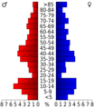
This chart shows the age groups of people in Hodgeman County based on the 2000 census.
-
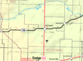
A map of Hodgeman County, Kansas, from 2005.


See also
 In Spanish: Condado de Hodgeman para niños
