Jetmore, Kansas facts for kids
Quick facts for kids
Jetmore, Kansas
|
|
|---|---|
|
City and County seat
|
|

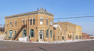
West side of Main Street (2010)
|
|

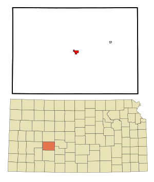
Location within Hodgeman County and Kansas
|
|

|
|
| Country | United States |
| State | Kansas |
| County | Hodgeman |
| Founded | 1870s |
| Platted | 1879 |
| Incorporated | 1887 |
| Named for | Col. Abraham Jetmore |
| Area | |
| • Total | 4.21 sq mi (10.90 km2) |
| • Land | 4.21 sq mi (10.90 km2) |
| • Water | 0.00 sq mi (0.00 km2) |
| Elevation | 2,461 ft (750 m) |
| Population
(2020)
|
|
| • Total | 770 |
| • Density | 182.9/sq mi (70.6/km2) |
| Time zone | UTC-6 (CST) |
| • Summer (DST) | UTC-5 (CDT) |
| ZIP code |
67854
|
| Area code | 620 |
| FIPS code | 20-35450 |
| GNIS ID | 2395469 |
Jetmore is a small city in Kansas, United States. It is the main town, or county seat, of Hodgeman County. In 2020, about 770 people lived there.
Contents
History of Jetmore
Jetmore started out with a different name! It was first called Buckner when it was planned in 1879. The name was changed to Jetmore in 1880. This new name honored a man named Colonel Abraham Buckles Jetmore. He was a lawyer from Topeka. Colonel Jetmore helped bring a railroad line through the city. He also helped make Jetmore the county seat.
Geography and Climate
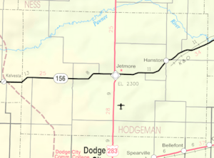
Jetmore is located in Kansas. The city covers about 4.49 square miles (11.63 square kilometers) of land. There is no water area within the city limits. A stream called Buckner Creek flows through Jetmore. This creek eventually joins the Pawnee River.
The ground in this area is made of certain types of rock. These rocks are called Greenhorn Limestone and Graneros Shale.
Weather in Jetmore
The weather in Jetmore has hot and humid summers. Winters are usually mild to cool. This type of weather is known as a humid subtropical climate. On climate maps, you might see it labeled as "Cfa".
| Climate data for Jetmore, Kansas, 1991–2020 normals, extremes 1900–present | |||||||||||||
|---|---|---|---|---|---|---|---|---|---|---|---|---|---|
| Month | Jan | Feb | Mar | Apr | May | Jun | Jul | Aug | Sep | Oct | Nov | Dec | Year |
| Record high °F (°C) | 82 (28) |
90 (32) |
94 (34) |
101 (38) |
105 (41) |
113 (45) |
116 (47) |
114 (46) |
109 (43) |
101 (38) |
93 (34) |
85 (29) |
116 (47) |
| Mean maximum °F (°C) | 68.4 (20.2) |
74.8 (23.8) |
82.8 (28.2) |
89.3 (31.8) |
95.6 (35.3) |
101.4 (38.6) |
104.8 (40.4) |
102.9 (39.4) |
98.7 (37.1) |
92.9 (33.8) |
78.5 (25.8) |
66.7 (19.3) |
105.7 (40.9) |
| Mean daily maximum °F (°C) | 44.1 (6.7) |
47.6 (8.7) |
58.2 (14.6) |
67.5 (19.7) |
77.2 (25.1) |
87.8 (31.0) |
93.6 (34.2) |
91.3 (32.9) |
83.3 (28.5) |
70.6 (21.4) |
56.3 (13.5) |
45.6 (7.6) |
68.6 (20.3) |
| Daily mean °F (°C) | 31.0 (−0.6) |
34.0 (1.1) |
43.5 (6.4) |
52.5 (11.4) |
63.2 (17.3) |
74.0 (23.3) |
79.6 (26.4) |
77.5 (25.3) |
69.0 (20.6) |
55.7 (13.2) |
42.4 (5.8) |
32.8 (0.4) |
54.6 (12.6) |
| Mean daily minimum °F (°C) | 17.9 (−7.8) |
20.4 (−6.4) |
28.8 (−1.8) |
37.6 (3.1) |
49.1 (9.5) |
60.1 (15.6) |
65.5 (18.6) |
63.7 (17.6) |
54.6 (12.6) |
40.9 (4.9) |
28.5 (−1.9) |
20.1 (−6.6) |
40.6 (4.8) |
| Mean minimum °F (°C) | 0.6 (−17.4) |
3.7 (−15.7) |
11.4 (−11.4) |
22.6 (−5.2) |
34.1 (1.2) |
47.9 (8.8) |
55.2 (12.9) |
54.4 (12.4) |
40.2 (4.6) |
24.3 (−4.3) |
11.8 (−11.2) |
3.9 (−15.6) |
−4.4 (−20.2) |
| Record low °F (°C) | −24 (−31) |
−21 (−29) |
−19 (−28) |
8 (−13) |
21 (−6) |
35 (2) |
42 (6) |
36 (2) |
27 (−3) |
9 (−13) |
−6 (−21) |
−20 (−29) |
−24 (−31) |
| Average precipitation inches (mm) | 0.64 (16) |
0.72 (18) |
1.47 (37) |
2.01 (51) |
3.66 (93) |
3.45 (88) |
3.63 (92) |
2.84 (72) |
1.65 (42) |
1.94 (49) |
0.77 (20) |
0.95 (24) |
23.73 (602) |
| Average snowfall inches (cm) | 6.1 (15) |
4.7 (12) |
3.3 (8.4) |
1.2 (3.0) |
0.0 (0.0) |
0.0 (0.0) |
0.0 (0.0) |
0.0 (0.0) |
0.0 (0.0) |
0.2 (0.51) |
1.6 (4.1) |
4.1 (10) |
21.2 (53.01) |
| Average precipitation days (≥ 0.01 in) | 2.4 | 2.6 | 3.7 | 5.0 | 6.9 | 7.2 | 6.7 | 6.0 | 3.5 | 3.8 | 2.3 | 2.3 | 52.4 |
| Average snowy days (≥ 0.1 in) | 1.8 | 1.4 | 1.2 | 0.4 | 0.0 | 0.0 | 0.0 | 0.0 | 0.0 | 0.2 | 0.4 | 1.2 | 6.6 |
| Source: NOAA | |||||||||||||
Population and People
The number of people living in Jetmore has changed over the years. Here's how the population has grown and shrunk:
| Historical population | |||
|---|---|---|---|
| Census | Pop. | %± | |
| 1890 | 324 | — | |
| 1900 | 230 | −29.0% | |
| 1910 | 317 | 37.8% | |
| 1920 | 559 | 76.3% | |
| 1930 | 914 | 63.5% | |
| 1940 | 881 | −3.6% | |
| 1950 | 988 | 12.1% | |
| 1960 | 1,028 | 4.0% | |
| 1970 | 936 | −8.9% | |
| 1980 | 862 | −7.9% | |
| 1990 | 850 | −1.4% | |
| 2000 | 903 | 6.2% | |
| 2010 | 867 | −4.0% | |
| 2020 | 770 | −11.2% | |
| U.S. Decennial Census | |||
Jetmore's Population in 2020
In 2020, the census counted 770 people in Jetmore. There were 333 households and 208 families. Most people living in Jetmore were white. A small number of people were from other racial backgrounds. About 5.84% of the population was Hispanic or Latino.
About 30.6% of households had children under 18. Many households were married couples living together. The average household had about 2.1 people. The average family had about 2.8 people.
The median age in Jetmore was 44.1 years old. This means half the people were younger and half were older than 44.1. About 25.5% of the population was under 18 years old. About 23.1% were 65 years or older.
Jetmore's Population in 2010
In 2010, the census showed 867 people living in Jetmore. There were 366 households. Most people were White. About 4.6% of the population was Hispanic or Latino.
About 32.2% of households had children under 18. Many households were married couples. The average household size was 2.33 people. The average family size was 2.97 people.
The median age in 2010 was 42.1 years. About 26.2% of residents were under 18. About 21.8% were 65 or older.
Education in Jetmore
Students in Jetmore attend schools in the Hodgeman County USD 227 public school district. This district has two schools for different age groups:
- Hodgeman County Middle/High School
- Hodgeman County Elementary School
Getting Around Jetmore
Airports Near Jetmore
- Jetmore Municipal Airport: This airport is for private planes. It does not have commercial flights.
- Dodge City Regional Airport: This is the closest airport with commercial flights. It is about 26 miles (42 km) away.
Major Roads in Jetmore
Two main highways pass through Jetmore:
 US-283
 K-156
K-156
See also
 In Spanish: Jetmore (Kansas) para niños
 | Misty Copeland |
 | Raven Wilkinson |
 | Debra Austin |
 | Aesha Ash |


