
Rice County, Kansas facts for kids
Quick facts for kids
Rice County
|
|
|---|---|
.jpg)
Rice County Courthouse in Lyons (2022)
|
|

Location within the U.S. state of Kansas
|
|
 Kansas's location within the U.S. |
|
| Country | |
| State | |
| Founded | February 26, 1867 |
| Named for | Samuel Allen Rice |
| Seat | Lyons |
| Largest city | Lyons |
| Area | |
| • Total | 728 sq mi (1,890 km2) |
| • Land | 726 sq mi (1,880 km2) |
| • Water | 1.7 sq mi (4 km2) 0.2%% |
| Population
(2020)
|
|
| • Total | 9,427 |
| • Estimate
(2023)
|
9,260 |
| • Density | 13.0/sq mi (5.0/km2) |
| Time zone | UTC−6 (Central) |
| • Summer (DST) | UTC−5 (CDT) |
| Congressional district | 1st |
Rice County is a place in the state of Kansas, in the United States. It's like a smaller region within the state. The main town and biggest city in Rice County is Lyons. In 2020, about 9,427 people lived there. The county got its name from Samuel Allen Rice, who was a brave general in the United States Army. He sadly died in a battle in Arkansas in 1864.
Contents
Discovering Rice County's Past
How Did Rice County Begin?
Long, long ago, for thousands of years, the wide-open Great Plains of North America were home to Native American tribes. These tribes often moved around, following animals and seasons.
Later, in the 1500s and 1600s, the country of France said they owned a huge part of North America. But after a big war in 1762, France secretly gave this land to Spain.
Becoming Part of the United States
In 1802, Spain gave most of this land back to France. Then, in 1803, the United States bought a massive amount of land from France. This huge purchase, called the Louisiana Purchase, included most of what is now Kansas. It was a really good deal!
In 1854, the area became known as the Kansas Territory. Then, in 1861, Kansas officially became the 34th state in the U.S. Rice County itself was created a few years later, in 1867.
The Famous Santa Fe Trail
A very important old path called the Santa Fe Trail used to go right through Rice County. This trail was used for trade and travel a long time ago. Today, you can still see the marks, or "ruts," left by wagons from the trail in some places!
Where is Rice County Located?
Rice County covers about 728 square miles. Most of this area is land, with only a small part (about 0.2%) being water.
Neighboring Counties
Rice County shares its borders with several other counties:
- Ellsworth County to the north
- McPherson County to the east
- Reno County to the south
- Stafford County to the southwest
- Barton County to the northwest
Special Natural Areas
Part of the Quivira National Wildlife Refuge is also found in Rice County. This is a protected area where wildlife can live safely.
Who Lives in Rice County?

In 2020, the population of Rice County was 9,427 people. The number of people living in the county has changed over the years. For example, in 1890, there were over 14,000 people, but the population has slowly decreased since then.
Most people in Rice County are White. There are also smaller groups of Black or African American, Native American, and Asian people. Some residents are also of Hispanic or Latino background.
Families make up a big part of Rice County. Many households have children living with them. The average family size is about three people.
Learning and Education
Colleges and Universities
- Sterling College in Sterling is a place where students can go to continue their education after high school.
Local School Districts
Students in Rice County attend schools in several different school districts:
- Sterling USD 376
- Chase–Raymond USD 401
- Lyons USD 405
- Little River–Windom USD 444
Towns and Communities

Rice County has several towns and smaller communities.
Cities in Rice County
- Alden
- Bushton
- Chase
- Frederick
- Geneseo
- Little River
- Lyons (This is the county seat, meaning it's the main administrative town.)
- Raymond
- Sterling
Smaller Communities (Unincorporated)
These are smaller places that don't have their own city government:
Former Towns (Ghost Towns)
Some towns that used to exist in Rice County are now "ghost towns," meaning people no longer live there:
Fun Facts About Rice County
Did you know that in the TV show Superman & Lois, Superman's hometown of Smallville is said to be in Rice County? That's a cool connection!
Images for kids
-

Samuel Allen Rice in 1864
-
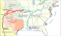
An 1845 map showing the Santa Fe Trail crossing Rice County
-
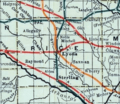
A railroad map of Rice County from 1915-1918
-

Grain elevators in Bushton, used for storing crops (2004)


See also
 In Spanish: Condado de Rice (Kansas) para niños
