
Harvey County, Kansas facts for kids
Quick facts for kids
Harvey County
|
|
|---|---|

Former Carnegie Library in Kansas, currently is the Harvey County Historical Museum
|
|

Location within the U.S. state of Kansas
|
|
 Kansas's location within the U.S. |
|
| Country | |
| State | |
| Founded | March 7, 1872 |
| Named for | James Harvey |
| Seat | Newton |
| Largest city | Newton |
| Area | |
| • Total | 541 sq mi (1,400 km2) |
| • Land | 540 sq mi (1,400 km2) |
| Population
(2020)
|
|
| • Total | 34,024 |
| • Estimate
(2023)
|
33,504 |
| • Density | 63.0/sq mi (24.3/km2) |
| Time zone | UTC−6 (Central) |
| • Summer (DST) | UTC−5 (CDT) |
| Congressional district | 4th |
Harvey County is a special area in the U.S. state of Kansas. It's called a county, which is like a smaller part of a state. The main city and where the county government is located is Newton. In 2020, about 34,024 people lived here. The county got its name from James Harvey, who was a U.S. senator and the fifth governor of Kansas.
Contents
History of Harvey County
Let's look at some important dates for Harvey County. In 1854, the area was organized as the Kansas Territory. Then, in 1861, Kansas officially became the 34th U.S. state.
A big change happened in 1871. The Atchison, Topeka and Santa Fe Railway built a main train line. It stretched from Emporia all the way to Newton. This helped the area grow a lot.
Just one year later, in 1872, Harvey County was officially created. It was named to honor James M. Harvey, who was the fifth Governor of Kansas.
Geography and Location

Harvey County is located in the middle of Kansas. The U.S. Census Bureau says the county covers about 541 square miles (1,400 km2) in total. Most of this area, about 540 square miles (1,400 km2), is land. A small part, about 1.0 square mile (2.6 km2), is water. The Little Arkansas River flows right through the county.
Neighboring Counties
Harvey County shares its borders with several other counties. These are:
- Marion County to the northeast
- Butler County to the east
- Sedgwick County to the south
- Reno County to the west
- McPherson County to the northwest
People and Population (Demographics)

Demographics is the study of people in a certain area. Harvey County is part of the larger Wichita Metropolitan Statistical Area. This means it's connected to the bigger city of Wichita.
Here's how the population of Harvey County has changed over the years:
| Historical population | |||
|---|---|---|---|
| Census | Pop. | %± | |
| 1880 | 11,451 | — | |
| 1890 | 17,601 | 53.7% | |
| 1900 | 17,591 | −0.1% | |
| 1910 | 19,200 | 9.1% | |
| 1920 | 20,744 | 8.0% | |
| 1930 | 22,120 | 6.6% | |
| 1940 | 21,712 | −1.8% | |
| 1950 | 21,698 | −0.1% | |
| 1960 | 25,865 | 19.2% | |
| 1970 | 27,236 | 5.3% | |
| 1980 | 30,531 | 12.1% | |
| 1990 | 31,028 | 1.6% | |
| 2000 | 32,869 | 5.9% | |
| 2010 | 34,684 | 5.5% | |
| 2020 | 34,024 | −1.9% | |
| 2023 (est.) | 33,504 | −3.4% | |
| U.S. Decennial Census 1790-1960 1900-1990 1990-2000 2010-2020 |
|||
Education in Harvey County
Harvey County has many places for students to learn, from colleges to local school districts.
Colleges and Universities
- Bethel College is located in North Newton.
- Hesston College is found in Hesston.
Local School Districts
These are the public school districts that serve students in Harvey County:
- Burrton USD 369
- Newton USD 373
- Sedgwick USD 439
- Halstead–Bentley USD 440
- Hesston USD 460
Some school district offices are in neighboring counties but still serve parts of Harvey County:
- Remington USD 206
- Peabody–Burns USD 398
- Goessel USD 411
- Moundridge USD 423
Communities of Harvey County
Harvey County is home to several cities, smaller communities, and even some places that used to be towns but are now empty.
Cities in Harvey County
These are the main cities where people live in Harvey County. A ‡ symbol means that a city also has a small part in a county next door.
Smaller Unincorporated Communities
These are smaller places that don't have their own city government:
Ghost Towns
A ghost town is a place that used to be a community but is now mostly empty.
- Annelly
- Van Arsdale
Townships
Harvey County is divided into smaller areas called townships. These are like local areas for organizing land and services. The cities of Halstead and Newton manage their own areas and are not part of the township population counts.
Images for kids
-
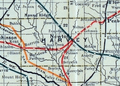
A railroad map of Harvey County from 1915-1918.

See also
 In Spanish: Condado de Harvey para niños
