McLain, Kansas facts for kids
Quick facts for kids
McLain, Kansas
|
|
|---|---|

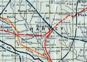
1915 Railroad Map of Harvey County
|
|
| Country | United States |
| State | Kansas |
| County | Harvey |
| Elevation | 1,509 ft (460 m) |
| Time zone | UTC-6 (CST) |
| • Summer (DST) | UTC-5 (CDT) |
| ZIP code |
67114
|
| Area code | 316 |
| FIPS code | 20-43897 |
| GNIS ID | 484650 |
McLain is a small, unincorporated community in Harvey County, Kansas, United States. An "unincorporated community" means it's a place where people live, but it doesn't have its own local government like a city or town. You might see its name spelled a few different ways, like McLains or McClain. It's located southeast of Newton, near the crossing of SE 36th Street and S Woodlawn Road.
A Look Back at McLain's History
McLain once had its own post office. This post office served the community from 1886 until 1906. A post office was very important for sending and receiving mail back then.
The community was also located along a Missouri Pacific Railroad track. This railway connected Newton and Whitewater. Trains used to run through McLain, helping people and goods travel. However, the train tracks were no longer used after 2003.
Schools in McLain
Students in McLain attend public schools. The community is part of the Newton USD 373 public school district. This district manages the schools in the area.
 | Emma Amos |
 | Edward Mitchell Bannister |
 | Larry D. Alexander |
 | Ernie Barnes |


