
Yoder, Kansas facts for kids
Quick facts for kids
Yoder, Kansas
|
|
|---|---|

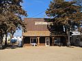
Hardware & Lumber (2014)
|
|

|
|

Yoder, Kansas
Location in Kansas

Yoder, Kansas
Location in the United States
|
|
| Country | United States |
| State | Kansas |
| County | Reno |
| Township | Yoder |
| Founded | 1889 |
| Named for | Valentine Yoder |
| Area | |
| • Total | 37.6 sq mi (97.5 km2) |
| • Land | 37.2 sq mi (96.5 km2) |
| • Water | 0.4 sq mi (1.0 km2) |
| Elevation | 1,539 ft (469 m) |
| Population
(2020)
|
|
| • Total | 165 |
| • Density | 4.388/sq mi (1.692/km2) |
| Time zone | UTC-6 (CST) |
| • Summer (DST) | UTC-5 (CDT) |
| ZIP code |
67585
|
| Area code | 620 |
| FIPS code | 20-80750 |
| GNIS ID | 473653 |
Yoder is a small community in Reno County, Kansas, United States. It's called a "census-designated place" (CDP) because it's a special area the government counts for population, even though it doesn't have its own city government. In 2020, about 165 people lived there.
Yoder is located about 10 miles southeast of Hutchinson along K-96. Even without a city government, Yoder has its own U.S. Post Office and a special ZIP code (67585). It is also known as a center for a local Amish community.
Contents
History of Yoder
How Yoder Got Its Name
The community of Yoder is named after its founder, Valentine Yoder. He was part of the Amish community.
Early Beginnings and Mail Service
The first post office in Yoder opened in November 1889. This was an important step for the community. It meant people could send and receive mail easily.
Former Air Force Base
Yoder was once home to a place called Naval Air Station Hutchinson. This base later changed its name to Hutchinson Air Force Station. Today, it is known as Sunflower Aerodrome Gliderport. It is now used for gliders, which are planes without engines.
Geography and Climate
Where is Yoder Located?
Yoder is in Reno County, Kansas. It covers an area of about 37.6 square miles. Most of this area is land, with a small part being water. The community is about 1,539 feet above sea level.
Understanding Yoder's Climate
The weather in Yoder has hot and humid summers. The winters are usually mild to cool. This type of weather is called a "humid subtropical climate." On climate maps, you might see it written as "Cfa." This means it has warm, wet summers and mild winters.
Population Information
| Historical population | |||
|---|---|---|---|
| Census | Pop. | %± | |
| 2010 | 194 | — | |
| 2020 | 165 | −14.9% | |
| U.S. Decennial Census | |||
How Many People Live in Yoder?
In 2020, the population of Yoder was 165 people. This number comes from the U.S. Census. The census counts how many people live in different areas every ten years. In 2010, the population was a bit higher, with 194 people living in Yoder.
Education in the Community
Local School District
Students in Yoder attend schools in the Haven USD 312 public school district. This district provides education for children in the area.
Fun Events in Yoder
Yoder Heritage Day
Every year, Yoder hosts a special event called Yoder Heritage Day. It takes place on the fourth Saturday in August. This day celebrates the community's history and culture.
Gallery
-
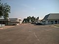
Looking south down Main Street (2006)
-
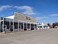
Demelia's Quilt Co (2014)
-
Discount Grocery (2014)
-
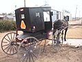
Horse-drawn carriage (2003)


See also
 In Spanish: Yoder (Kansas) para niños
