
Custer County, Oklahoma facts for kids
Quick facts for kids
Custer County
|
|
|---|---|

|
|

Location within the U.S. state of Oklahoma
|
|
 Oklahoma's location within the U.S. |
|
| Country | |
| State | |
| Founded | 1891 |
| Named for | General George A. Custer |
| Seat | Arapaho |
| Largest city | Weatherford |
| Area | |
| • Total | 1,002 sq mi (2,600 km2) |
| • Land | 989 sq mi (2,560 km2) |
| • Water | 13 sq mi (30 km2) 1.3%% |
| Population
(2020)
|
|
| • Total | 28,513 |
| • Density | 28.456/sq mi (10.987/km2) |
| Time zone | UTC−6 (Central) |
| • Summer (DST) | UTC−5 (CDT) |
| Congressional district | 3rd |
Custer County is a county in the state of Oklahoma, USA. In 2020, about 28,513 people lived here. The main town, or county seat, is Arapaho. The county is named after General George Armstrong Custer.
Custer County is part of the Weatherford, Oklahoma, area. This means it's a smaller urban area that is connected to Weatherford.
Contents
History of Custer County
Custer County was created in 1891. It was first called G County. This land used to belong to the Cheyenne people. On November 6, 1896, its name changed to Custer County. It was named after General George Armstrong Custer. He was involved in the Battle of the Washita. This battle happened about 20 miles west of the county.
American settlers moved into the county during a land run on April 19, 1892. On that same day, the first local newspaper, the Arapaho Arrow, was published.
Early Roads and Trails
Before Custer County was officially formed, several important trips and road projects happened here.
One of the first was Josiah Gregg's journey. He traveled from Santa Fe, New Mexico to Fort Smith, Arkansas between 1839 and 1840. This route became known as the Fort Smith to Santa Fe Trail. It passed through the county near Hydro, Oklahoma and Thomas, Oklahoma.
In 1849, many people looking for gold traveled through the area. One large group had 1,500 people. They were guided by Captain Randolph B. Marcy. They created a new path towards the Antelope Hills. Travelers often complained about how hard it was to cross the many deep creeks.
In 1853, the first railroad survey was done. This survey was for a railroad from Fort Smith, Arkansas, to Los Angeles, California. Lieutenant Amiel Weeks Whipple led this project. His team entered Custer County in the southeast. He suggested building bridges over the streams.
Five years later, in 1858, Lieutenant Edward F. Beale was asked to improve roads. He worked on a road system from Fort Smith, Arkansas, to Albuquerque, New Mexico. The goal was to make one main road instead of many small ones. Beale's crew built seven temporary wooden bridges across creeks in Custer County. These bridges helped travelers move through the hilly land.
This road became the first federally funded interstate highway in the American Southwest. It cost $210,000 to build from Fort Smith to Los Angeles. Some historians call Route 66 the "Mother Road." If so, the Beale Wagon Road could be called the "Grandmother Road."
Life on the Beale Wagon Road
The Beale Wagon Road was not used much in Custer County at first. The American Civil War stopped most travel. People then used the Santa Fe Trail through Kansas. After the war, traffic slowly increased.
In 1866, a large group of U.S. troops passed through. This included African American soldiers known as the Buffalo Soldiers. In 1868, General Custer's troops also used part of the road. They followed it near Clinton, Oklahoma along the Washita River.
Later, Cheyenne and Arapaho Native American groups used Beale's Route. They traveled through their lands during the reservation years. When Custer County was opened to settlers in 1892, the Beale Wagon Road became a main road. Farmers used it to travel to nearby towns. Over time, new county roads were built, and the Beale Wagon Road lost its importance.
Geography
Custer County covers about 1,002 square miles. Most of this (989 square miles) is land. About 13 square miles (1.3%) is water.
Major Highways
 Interstate 40
 U.S. Highway 183
 State Highway 33
 State Highway 44
 State Highway 47
 State Highway 54
 State Highway 73
Neighboring Counties
- Dewey County (north)
- Blaine County (east)
- Caddo County (southeast)
- Washita County (south)
- Beckham County (southwest)
- Roger Mills County (west)
Protected Areas
- Washita National Wildlife Refuge is a special area in the county. It protects wildlife and their natural homes.
People of Custer County
| Historical population | |||
|---|---|---|---|
| Census | Pop. | %± | |
| 1900 | 12,264 | — | |
| 1910 | 23,231 | 89.4% | |
| 1920 | 18,736 | −19.3% | |
| 1930 | 27,517 | 46.9% | |
| 1940 | 23,068 | −16.2% | |
| 1950 | 21,097 | −8.5% | |
| 1960 | 21,040 | −0.3% | |
| 1970 | 22,665 | 7.7% | |
| 1980 | 25,995 | 14.7% | |
| 1990 | 26,897 | 3.5% | |
| 2000 | 26,142 | −2.8% | |
| 2010 | 27,469 | 5.1% | |
| 2020 | 28,513 | 3.8% | |
| U.S. Decennial Census 1790-1960 1900-1990 1990-2000 2010 |
|||

In 2000, there were 26,142 people living in Custer County. The population grew to 28,513 by 2020. Most people in the county are White (about 81%). There are also people who are Black, Native American, Asian, and from other backgrounds. About 9% of the population is Hispanic or Latino.
In 2000, about 30% of households had children under 18 living with them. The average household had about 2.45 people. The median age in the county was 33 years old. This means half the people were older than 33, and half were younger.
Towns and Communities
Custer County has several cities, towns, and smaller communities.
Cities
- Clinton (a small part is in Washita County)
- Thomas
- Weatherford
Towns
- Arapaho (This is the county seat, where the county government is located)
- Butler
- Custer City
- Hammon (most of this town is in Roger Mills County)
Smaller Communities
- Anthon
- Carpenter (also in Roger Mills County)
- Cody
- Dead Women Crossing
- East Junction
- Foley
- Hammon Junction
- McClure
- Moorewood
- Parkersburg
- Ralph
- Stafford
- Sunset
Old Towns (Ghost Towns)
Education
Many school districts serve the students of Custer County. All of them teach students from kindergarten through 12th grade.
- Arapaho Public Schools
- Canute Public Schools
- Clinton Public Schools
- Elk City Public Schools
- Hammon Public Schools
- Hydro-Eakly Public Schools
- Leedey Public Schools
- Thomas-Fay-Custer Unified Schools
- Weatherford Public Schools
Images for kids
-
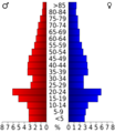
Age pyramid for Custer County, Oklahoma, based on census 2000 data.
See also
 In Spanish: Condado de Custer (Oklahoma) para niños
