Washita County, Oklahoma facts for kids
Quick facts for kids
Washita County
|
|
|---|---|

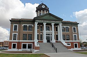
The Washita County Courthouse in 2015.
|
|

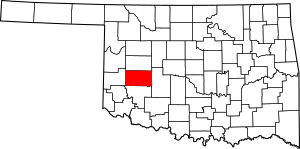
Location within the U.S. state of Oklahoma
|
|
 Oklahoma's location within the U.S. |
|
| Country | |
| State | |
| Founded | 1891 |
| Named for | Washita River |
| Seat | New Cordell |
| Largest city | New Cordell |
| Area | |
| • Total | 1,009 sq mi (2,610 km2) |
| • Land | 1,003 sq mi (2,600 km2) |
| • Water | 5.6 sq mi (15 km2) 0.6%% |
| Population
(2020)
|
|
| • Total | 10,924 |
| • Density | 10.827/sq mi (4.1802/km2) |
| Time zone | UTC−6 (Central) |
| • Summer (DST) | UTC−5 (CDT) |
| Congressional district | 3rd |
Washita County is a county located in the state of Oklahoma, USA. As of 2020, about 10,924 people lived there. Its main town, or county seat, is New Cordell. The county was created in 1891. Before New Cordell, the county seat was in Cloud Chief.
Contents
History of Washita County
Early Land Use
In 1883, a man named John Miles rented a huge area of land, about 3 million acres, from the Cheyenne and Arapaho tribes. He rented it to seven cattle ranchers. However, problems soon started between the ranchers and the tribes. In 1885, the government ended all these rental agreements. They told the cattle ranchers to move their animals away.
Seger's Colony
The area began to be settled in 1886. That's when John Seger started a special community along Cobb Creek. Seger convinced 120 Cheyenne and Arapaho people to live near an old ranch. His goal was to teach these tribes how to farm using new methods. This community was first called "Seger's Colony." Later, its name was shortened to the town we know today as Colony, Oklahoma.
The Land Run and County Seat
The government later announced that extra lands from the Cheyenne and Arapaho Indian Reservation were open for new settlers. This happened during the Land Run of 1892 on April 19, 1892. At that time, a town called Tacola was chosen as the county seat. Its name was soon changed to Cloud Chief.
Oklahoma Territory and River Name
Washita County is in the western part of Oklahoma. This area was once called County H of the Territory of Oklahoma. This territory existed from 1890 until 1907. In 1907, it joined with the Indian territory to become the state of Oklahoma. The county itself was named after the Washita River. French explorers had called this river "Faux Ouachita," which means "false Washita." They did this to tell it apart from another Ouachita River in Arkansas and Louisiana. The spelling of the Oklahoma river's name was changed by using a "w" instead of "ou."
Changing the County Seat
In 1900, people voted to make the town of Cordell the county seat. Most people liked Cordell because it was in the middle of the county. But the election results were challenged in court. In 1904, the Oklahoma Territorial Supreme Court said the county seat could not be moved without permission from the U.S. government. So, in 1906, the U.S. Congress officially moved the county seat to Cordell. When Oklahoma became a state in 1907, its new constitution confirmed Cordell (which was then called New Cordell) as the county seat.
Flood Control Dam
In 1948, an important project was finished in Washita County. It was the nation's first flood control dam built under a special law from 1944. This dam was built in the Cloud Creek Watershed to help control floods.
Geography
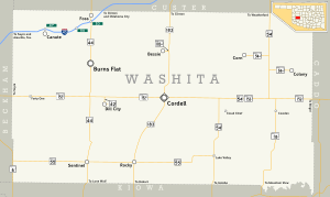
Washita County covers a total area of about 1,009 square miles. Most of this area, about 1,006 square miles, is land. Only a small part, about 5.6 square miles (0.6%), is water. The county is located in a part of Oklahoma called the Western Redbeds Plains. The Washita River flows through and drains most of the county. However, the very southwest corner of the county drains into the North Fork of the Red River.
Neighboring Counties
- Custer County - north
- Caddo County - east
- Kiowa County - south
- Beckham County - west
People of Washita County (Demographics)
| Historical population | |||
|---|---|---|---|
| Census | Pop. | %± | |
| 1910 | 25,034 | — | |
| 1920 | 22,237 | −11.2% | |
| 1930 | 29,435 | 32.4% | |
| 1940 | 22,279 | −24.3% | |
| 1950 | 17,657 | −20.7% | |
| 1960 | 18,121 | 2.6% | |
| 1970 | 12,141 | −33.0% | |
| 1980 | 13,798 | 13.6% | |
| 1990 | 11,441 | −17.1% | |
| 2000 | 11,508 | 0.6% | |
| 2010 | 11,629 | 1.1% | |
| 2020 | 10,924 | −6.1% | |
| U.S. Decennial Census 1790-1960 1900-1990 1990-2000 2010 |
|||
In 2010, there were 11,629 people living in Washita County. These people lived in 4,599 households, and 3,186 of these were families. On average, there were about 11.5 people per square mile. There were also 5,479 housing units, like houses or apartments.
Most people in the county were white (95.8%). About 3% were Native American, and 0.7% were Black or African American. A small number (0.2%) were Asian. Some people (3.6%) were from other races, and 4.2% were from two or more races. About 8% of the people were Hispanic or Latino. Most people (96%) spoke only English, while 3.3% spoke Spanish.
About 33.1% of households had children under 18 living with them. More than half (54.8%) were married couples living together. About 9.5% of households had a female head with no husband, and 5% had a male head with no wife. About 27.1% of households were people living alone. Of those living alone, 13% were 65 years old or older. The average household had 2.48 people, and the average family had 2.98 people.
The median age in the county was 39 years old. About 25.8% of the population was under 18. About 17.1% were 65 years or older. The median income for a household was $44,331. For families, the median income was $56,619. About 12% of families and 16% of all people lived below the poverty line. This included 25% of those under 18 and 10.7% of those 65 or older.
Communities
Cities
- Clinton (part)
- New Cordell (county seat)
Unincorporated communities
Education
Washita County has several school districts:
- Burns Flat-Dill City Schools
- Canute Public Schools
- Carnegie Public Schools
- Clinton Public Schools
- Cordell Public Schools
- Elk City Public Schools
- Hydro-Eakly Public Schools
- Merritt Public Schools
- Mountain View-Gotebo Schools
- Sentinel Public Schools
- Weatherford Public Schools
See also
 In Spanish: Condado de Washita para niños
 | Percy Lavon Julian |
 | Katherine Johnson |
 | George Washington Carver |
 | Annie Easley |


