North Fork Red River facts for kids
Quick facts for kids North Fork Red River |
|
|---|---|

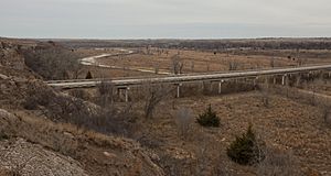
North Fork Red River in Wheeler County, Texas
|
|

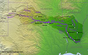
Map of the Red River watershed
|
|
| Physical characteristics | |
| Main source | Gray County, Texas 3,471 ft (1,058 m) 35°24′10″N 101°04′47″W / 35.4028244°N 101.0795982°W |
| River mouth | Tillman County, Oklahoma 1,181 ft (360 m) 34°19′00″N 99°12′01″W / 34.3167496°N 99.2003587°W |
| Length | 271 mi (436 km) |
| Basin features | |
| River system | Red River |
| Basin size | 5,000 sq mi (13,000 km2) |
The North Fork Red River is a river in the United States. It's sometimes just called the "North Fork". This river is a branch of the larger Red River of the South. It flows for about 271 miles (436 km). The river starts in Gray County, Texas. It ends where it meets the Prairie Dog Town Fork of the Red River. This meeting point is right on the border between Texas and Oklahoma.
The River's Journey: Where Does It Flow?
The North Fork Red River begins in central Gray County, Texas. From there, it flows towards the east. It passes through Wheeler County, Texas, and then enters Oklahoma.
Key Streams Joining the North Fork
Just before it crosses into Oklahoma, the North Fork is joined by McClellan Creek. This is the main stream that flows into the North Fork. Once in Oklahoma, the river continues east through Beckham County. Here, another stream called Sweetwater Creek adds its waters.
Creating Lake Altus-Lugert
The river then turns to the southeast. It forms the border between Greer and Kiowa counties. In this area, the river's flow is stopped to create Lake Altus-Lugert. This lake is an important water source.
Final Path to the Red River
In southern Greer County, the North Fork meets Elm Creek. After this, it turns more to the south. It forms the border between Kiowa County and Jackson County, Oklahoma. It also borders Jackson County and Tillman counties. Finally, it joins the Prairie Dog Town Fork of the Red River. This meeting point is on the Texas-Oklahoma border. It's about 12.7 miles (20.4 km) northeast of Vernon, Texas.
River's Drop in Elevation
From where it starts to where it joins the Red River, the North Fork drops about 2,098 feet (639 m). The land it flows through is mostly flat or gently rolling. There are some shallow dips along its path.
Historic Importance: A River's Role in Borders
The North Fork Red River played a big part in defining borders. This was especially true after a treaty in 1819.
The Adams-Onís Treaty and Early Borders
In 1819, the Adams-Onís Treaty was signed. This agreement helped define the border between the United States and New Spain (which is now Mexico). The treaty said that the Red River would be part of this border. For a while, people thought the North Fork was the main Red River channel. So, it was considered part of the border.
Discovering the True Main Channel
However, in 1852, an exploration called the Marcy Expedition happened. They found out that the true main channel of the Red River was actually the South Fork. This river is now known as the Prairie Dog Town Fork of the Red River.
Land Disputes and the Supreme Court
Because of this discovery, the U.S. government claimed the land between the two Red River streams. This land went as far as the 100th Meridian. After the Republic of Texas joined the United States, Texas still claimed this area. They even named it Greer County. This led to a big disagreement. Texas sued the United States over the land. The case went to the United States Supreme Court. The United States won the lawsuit.
Changes to the Border
As a result of the Supreme Court's decision, Greer County, Texas, became part of Oklahoma Territory. This meant the North Fork was no longer the border between Texas and the United States. The border was now officially the Prairie Dog Town Fork.
 | Leon Lynch |
 | Milton P. Webster |
 | Ferdinand Smith |

