Prairie Dog Town Fork Red River facts for kids
Quick facts for kids Prairie Dog Town Fork Red River |
|
|---|---|

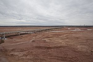
Prairie Dog Town Fork in Armstrong County
|
|

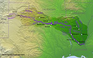
Map of Red River and tributaries
|
|
| Country | |
| Physical characteristics | |
| Main source | Randall County, Texas 3,471 ft (1,058 m) 35°00′09″N 101°54′10″W / 35.00250°N 101.90278°W |
| River mouth | Harmon County, Oklahoma 1,545 ft (471 m) 34°34′41″N 99°58′00″W / 34.57806°N 99.96667°W |
| Length | 120 mi (190 km) |
| Basin features | |
| River system | Red River |
| Basin size | 7,630 sq mi (19,800 km2) |
| Tributaries |
|
The Prairie Dog Town Fork Red River is a river in the United States. It is about 120 miles (193 km) long. This river is known for its sandy, braided channels.
It starts where two smaller streams, Palo Duro Creek and Tierra Blanca Creek, meet. This meeting point is near Canyon, Texas in Randall County, Texas. The river then flows east-southeast. It eventually joins the main Red River. This happens close to Hollis, Oklahoma.
Contents
Where Does the River Flow?
The Prairie Dog Town Fork Red River is one of the main starting points for the larger Red River. It begins in Randall County, Texas. This area is part of a flat land called the Llano Estacado.
Journey Through Palo Duro Canyon
The river first flows northeast, then turns southeast. It travels through the amazing Palo Duro Canyon. Here, springs feed the river, keeping water flowing. Heavy rain can make the river much bigger. The river also provides water for places like Lake Tanglewood and River Falls. It then continues its journey through Palo Duro Canyon State Park.
Flowing Through Texas Counties
After the canyon, the river keeps going southeast. It passes through parts of Armstrong County, Texas and Briscoe County, Texas. It then leaves Palo Duro Canyon. The river enters the rolling, reddish land of Hall County, Texas. Here, it meets another river, the Little Red River.
The Prairie Dog Town Fork continues through Hall County, Texas and Childress County, Texas. It merges with Buck Creek. At this point, it officially becomes the Red River. This happens near Hollis, Oklahoma.
A Natural State Border
When the Prairie Dog Town Fork crosses the 100th meridian in Childress County, something interesting happens. The south bank of the river becomes the border. It marks the line between Texas and Oklahoma.
What's in a Name?
The official name of this river is "Prairie Dog Town Fork Red River." This was decided in 1959. The United States Board on Geographic Names made this decision. They wanted to make sure everyone used the same name.
So, it's not "Prairie Dog Town Fork of the Red River." It's also not "South Fork of the Red River." The correct and official name is "Prairie Dog Town Fork Red River."
 | Stephanie Wilson |
 | Charles Bolden |
 | Ronald McNair |
 | Frederick D. Gregory |

