
Palo Duro Canyon facts for kids
Quick facts for kids Palo Duro Canyon |
|
|---|---|

View from the Interpretive Center
|
|

Palo Duro
Location in Texas
|
|
| Floor elevation | 2,828 ft (862 m) |
| Length | 120 mi (190 km) |
| Width | 20 mi (32 km) |
| Depth | 880 ft (270 m) |
| Geography | |
| Rivers | Prairie Dog Town Fork Red River |
| Designated: | 1976 |
Palo Duro Canyon is a huge canyon in the Texas Panhandle. It is located near the cities of Amarillo and Canyon. It is the second-largest canyon in the United States.
This amazing canyon is about 120 miles (193 km) long. It is usually 6 miles (10 km) wide, but in some places, it can be up to 20 miles (32 km) wide. The canyon is about 820 feet (250 meters) deep, but in some spots, it reaches 1,000 feet (305 meters) deep. Palo Duro means "hard stick" in Spanish. People often call it "The Grand Canyon of Texas." This is because of its size and its cool rock features. These include colorful rock layers and steep cliff walls, much like the famous Grand Canyon.
Contents
How Palo Duro Canyon Formed

The Prairie Dog Town Fork Red River created Palo Duro Canyon. This river flows across the flat land of the Llano Estacado in West Texas. Then, it suddenly drops off the Caprock Escarpment. Over thousands of years, water erosion has shaped the canyon's rock formations.
Some famous rock formations in the canyon are caves and hoodoos. A hoodoo is a tall, thin rock spire. One of the most well-known features is the Lighthouse Rock. There is a 6-mile (10 km) round-trip trail that leads to this formation.

The Prairie Dog Town Fork Red River carved out Palo Duro Canyon. This happened during the Ice Age, when the whole area was lifted up. Most of the rock layers you see in the canyon were formed during the Permian and Triassic periods. These layers are stacked from oldest at the bottom to youngest at the top.
Rock Layers of the Canyon
The different rock layers tell a story about the Earth's past. Each layer was formed in a different way.
Quartermaster Formation
This is the oldest layer, from the Permian period. It forms the red, lower slopes of the canyon. This rock was laid down in a shallow sea near the shore. It has siltstone and shale with wavy patterns from water. It also has signs of dry tidal flats, like gypsum and halite salt deposits. The red color shows that the rocks were exposed to air and rusted. This layer is about 60 feet (18 meters) thick.
Tecovas Formation
This colorful layer is from the Triassic period. It is made of shale, siltstone, and sandstone. These rocks were deposited in streams and swamps. Their different colors show how much oxygen was around when they formed. This layer contains fossils of ancient animals like phytosaurs (like crocodiles), amphibians, and fish. You can also find petrified wood here. This formation is about 200 feet (61 meters) thick. A white sandstone band about 15 feet (4.6 meters) thick is in the middle of this layer.
Trujillo Formation
This Triassic layer is harder than the Tecovas layer below it. It forms many of the canyon's ledges. It is made of coarse sandstone. This sandstone was deposited by rivers. Fossils are rare in this layer. This formation creates cliffs and prominent flat areas (benches) within the canyon. The Lighthouse and other hoodoos are formed from this erosion-resistant sandstone.
Ogallala Formation
This layer is at the very top of the canyon. It forms the cliffs and ledges there. It is from the late Miocene to early Pliocene periods. It is made of sandstone, siltstone, and conglomerate. These rocks came from the Rocky Mountains when they were uplifted. This layer is very important because it forms the Ogallala Aquifer. This aquifer is a huge underground water source for much of the High Plains.
Fossils found in the Ogallala Formation include saber-toothed cats (Smilodon), bone-crushing dogs, mastodons, horses, long-necked camels, rhinoceroses, and large tortoises. The upper part of this formation has thick deposits of caliche, which is a hardened layer of calcium carbonate.
The harder Ogallala and Trujillo formations created the steeper walls of the canyon. This is because they resisted erosion more than the softer layers.


History of Palo Duro Canyon
People have lived in Palo Duro Canyon for a very long time. The first signs of humans here date back about 10,000 to 15,000 years ago. It is believed that people have lived here continuously ever since. Native Americans loved the canyon because of its water, many animals for hunting, edible plants, and protection from bad weather.
Early Explorers and Tribes
The first European explorers to find the canyon were part of the Coronado expedition in 1541. At that time, Apache Indians lived in Palo Duro. Later, the Comanche and Kiowa tribes moved in. They had an advantage because they owned horses, which the Spanish had brought to America. These tribes traded with people called Comancheros from nearby New Mexico.
In 1852, a United States military team led by Captain Randolph B. Marcy mapped the canyon. They were looking for where the Red River began. The land stayed under American Indian control until 1874. That year, a military group led by Colonel Ranald S. Mackenzie was sent to move the Indians to reservations in Oklahoma. During the Battle of Palo Duro Canyon, Mackenzie's group captured about 1,200 of the Indians' horses and killed them in nearby Tule Canyon. After this, the Comanche and Kiowa tribes agreed to leave the area.
Ranching and Park Creation
Soon after, in 1876, Charles Goodnight and a rich man named John Adair started the JA Ranch in Palo Duro Canyon. Colonel Goodnight helped manage the ranch until 1890. For the next 50 years, the canyon was privately owned. However, it became a popular place for local people to visit.
In 1905, Charles N. Gould made a geologic map of the canyon. He also named its different rock layers. In 1931, a major landowner allowed public access to the canyon for two years. In 1934, the State of Texas bought the upper part of the canyon. This area became the 20,000-acre (8,094 ha) Palo Duro Canyon State Park. The city of Canyon is closer to the park than Amarillo. In 1976, Palo Duro Canyon State Park was named a National Natural Landmark.
Park Development
From 1933 to 1937, seven groups from the Civilian Conservation Corps (CCC) helped build the park. The CCC was a program during the Great Depression that put people to work. These groups built Park Road 5, a two-lane road from the canyon rim down to the floor. They also built the park headquarters, bridges, and buildings like the Coronado Lodge. They created picnic and camping areas with tables, fireplaces, and trash cans.
Today, the Texas Department of Transportation has built new bridges over water crossings. This makes it easier for cars to get around, especially after heavy rains. They have also paved areas and added more campsites, pavilions, and hiking trails.
Things to Do at Palo Duro Canyon
Palo Duro Canyon is part of the Texas State Parks system. You can enter the park with a Texas Parks Pass.
There are many fun activities to do in the park:
- Hiking and Biking: There are 16 trails for hiking, biking, and horseback riding. These trails range from very short (0.05 miles) to longer ones (4.4 miles).
- Camping: You can camp with tents or RVs. There are also special sites if you want to bring horses for riding.
- Cabins: You can rent cabins that sit on the canyon's outer rim. They offer amazing views of the canyon and the sunrise.
- Group Events: The park has spaces for group retreats, youth groups, and even weddings. The Mack Dick Pavilion is a popular spot for weddings because the canyon makes a beautiful background.
Palo Duro Canyon in Art and Music
Palo Duro Canyon has inspired many artists and musicians.
Paintings by Georgia O'Keeffe
The famous painter Georgia O'Keeffe lived near the canyon in the early 1900s. She said the Palo Duro was "a burning, seething cauldron, filled with dramatic light and color." She painted many pictures of Palo Duro Canyon between 1916 and 1918. At that time, she was an art teacher at West Texas State Normal College.

The Texas Musical Drama
Every summer, an outdoor historical musical drama called Texas is performed in the canyon. Actors, singers, and dancers from the Texas Panhandle put on the show. Playwright Paul Eliot Green created it. The first show was on July 1, 1966, at the Pioneer Amphitheatre in Palo Duro Canyon State Park. It has been performed every summer since then. Texas is known as "the best-attended outdoor history drama in the nation."
Symphony by Samuel Jones
American composer Samuel Jones wrote a symphony called "Palo Duro Canyon." It was first performed on May 1, 1992, right in the Palo Duro Canyon State Park. The Amarillo Symphony played it. The composer said he wanted the music to show how long it took for the canyon to form. He also wanted to honor Native Americans, who saw the canyon as a sacred place. He hoped to capture the magical feeling people get when they first see the canyon's colorful vastness.
A TV show about the canyon, composer, and symphony was shown on PBS stations. Later, the Seattle Symphony released a recording of the music. Another recording was released in 2018 by the London Symphony Orchestra.
Images for kids
-
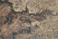
Astronaut photo of Palo Duro and Caprock Canyons in early 2022

See also
 In Spanish: Cañón de Palo Duro para niños
