Randall County, Texas facts for kids
Quick facts for kids
Randall County
|
||
|---|---|---|

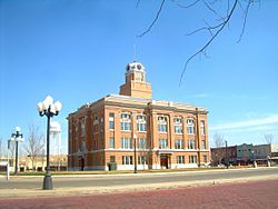
The Randall County Courthouse in 2011
|
||
|
||

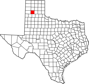
Location within the U.S. state of Texas
|
||
 Texas's location within the U.S. |
||
| Country | ||
| State | ||
| Founded | 1889 | |
| Named for | Horace Randal | |
| Seat | Canyon | |
| Largest city | Amarillo | |
| Area | ||
| • Total | 922 sq mi (2,390 km2) | |
| • Land | 912 sq mi (2,360 km2) | |
| • Water | 11 sq mi (30 km2) 1.2% | |
| Population
(2020)
|
||
| • Total | 140,753 | |
| • Density | 152.66/sq mi (58.94/km2) | |
| Time zone | UTC−6 (Central) | |
| • Summer (DST) | UTC−5 (CDT) | |
| Congressional district | 13th | |
Randall County is a place in the U.S. state of Texas. It's like a big neighborhood or district within the state. In 2020, about 140,753 people lived there. The main town, or county seat, is Canyon.
Randall County was officially created in 1876 and started operating in 1889. It was named after Horace Randal, who was a general during the American Civil War. He died in a battle called Battle of Jenkins Ferry. Interestingly, the county's name is spelled a little differently from his name because of a mistake when the law was written.
Randall County is right next to Potter County. Together, they form the larger Amarillo area, which is a big city region.
A very large ranch called the JA Ranch used to cover parts of Randall County. This ranch was started by two famous people, Charles Goodnight and John George Adair. It was so big it stretched into six different counties!
Contents
Geography
Randall County covers a total area of about 922 square miles. Most of this is land (912 square miles), and a small part (11 square miles) is water.
One of the most amazing natural places in Randall County is Palo Duro Canyon. It's the second-largest canyon in the entire United States!
Major roads
Getting around Randall County is easy with these important roads:
 Interstate 27
 U.S. Highway 60
 U.S. Highway 87
 State Highway 217
 Loop 335
Neighboring counties
Randall County shares its borders with several other counties:
- Potter County (to the north)
- Oldham County (to the northwest)
- Armstrong County (to the east)
- Carson County (to the northeast)
- Swisher County (to the south)
- Briscoe County (to the southeast)
- Castro County (to the southwest)
- Deaf Smith County (to the west)
Protected natural areas
- Buffalo Lake National Wildlife Refuge is a special area in Randall County where wildlife is protected.
Population facts
| Historical population | |||
|---|---|---|---|
| Census | Pop. | %± | |
| 1880 | 3 | — | |
| 1890 | 187 | 6,133.3% | |
| 1900 | 963 | 415.0% | |
| 1910 | 3,312 | 243.9% | |
| 1920 | 3,675 | 11.0% | |
| 1930 | 7,071 | 92.4% | |
| 1940 | 7,185 | 1.6% | |
| 1950 | 13,774 | 91.7% | |
| 1960 | 33,913 | 146.2% | |
| 1970 | 53,885 | 58.9% | |
| 1980 | 75,062 | 39.3% | |
| 1990 | 89,673 | 19.5% | |
| 2000 | 104,312 | 16.3% | |
| 2010 | 120,725 | 15.7% | |
| 2020 | 140,753 | 16.6% | |
| U.S. Decennial Census 1850–2010 2010 2020 |
|||
Randall County has grown a lot over the years. In 1880, only 3 people lived there, but by 2020, the population was over 140,000!
The people living in Randall County come from many different backgrounds. In 2020, about 67.8% of the people were White. About 3.2% were Black or African American, and 1.8% were Asian. Many people also identify as Hispanic or Latino, making up about 22.4% of the population. This mix of cultures makes Randall County a diverse place.
Communities
Randall County has several towns and cities where people live.
Cities
- Amarillo (part of this city is also in Potter County)
- Canyon (This is the main town, or county seat)
Towns
- Happy (most of this town is in Swisher County)
Villages
Unincorporated communities
These are smaller places that are not officially part of a city or town:
Ghost towns
- Cita (This is a town that used to exist but is now abandoned.)
Education
Students in Randall County go to schools in several different school districts:
- Amarillo Independent School District
- Bushland Independent School District
- Canyon Independent School District
- Happy Independent School District
- Wildorado Independent School District
After high school, students in the county can attend Amarillo College.
See also
 In Spanish: Condado de Randall para niños
 | James B. Knighten |
 | Azellia White |
 | Willa Brown |


