Swisher County, Texas facts for kids
Quick facts for kids
Swisher County
|
|
|---|---|

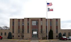
The Swisher County Courthouse in Tulia
|
|

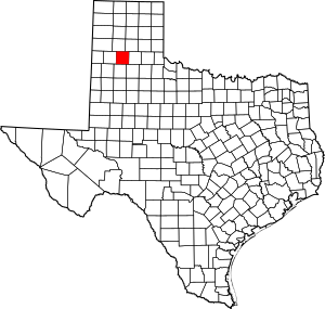
Location within the U.S. state of Texas
|
|
 Texas's location within the U.S. |
|
| Country | |
| State | |
| Founded | 1890 |
| Named for | James G. Swisher |
| Seat | Tulia |
| Largest city | Tulia |
| Area | |
| • Total | 901 sq mi (2,330 km2) |
| • Land | 890 sq mi (2,300 km2) |
| • Water | 11 sq mi (30 km2) 1.2% |
| Population
(2020)
|
|
| • Total | 6,971 |
| • Density | 7.737/sq mi (2.9873/km2) |
| Time zone | UTC−6 (Central) |
| • Summer (DST) | UTC−5 (CDT) |
| Congressional district | 19th |
Swisher County is a place in the U.S. state of Texas. It's like a smaller region within the state. In 2020, about 6,971 people lived there. The main town, or county seat, is Tulia.
Swisher County was created in 1876. It was officially set up in 1890. The county is named after James G. Swisher. He was a soldier in the Texas Revolution. He also signed the paper that declared Texas independent.
A very large ranch called the JA Ranch once reached into Swisher County. This ranch was started by Charles Goodnight and John George Adair.
Contents
History of Swisher County
Early People in the Area
Long ago, Apache people lived in the area that is now Swisher County. Around the year 1700, the Comanche people became the main group. The United States Army fought the Comanches in the Red River War in 1874. No big battles happened right in Swisher County. After a battle nearby, many Native American horses were shot. Later, in 1876, the Comanches tried to stop white settlers from coming. They wanted to protect their hunting lands.
How the County Grew
In 1876, the Texas government created Swisher County. It was formed from parts of other areas. In 1880, the county was officially organized. Tulia became its main town.
Not many people lived in the area at first. But in 1883, the JA Ranch came to the county. This helped bring more people. For many years, ranching was the main activity. Good water found underground helped ranchers. They used windmills to get water for their animals.
In 1906, a railroad line came through Swisher County. This connected the county to other towns like Amarillo and Lubbock. The railroad helped the county's economy grow.
The Great Depression in the 1930s was a hard time for the county. But building new roads helped a little. Then, World War II created a demand for goods. Also, new ways to water crops helped the county's economy get better. Farmers started using underground water from the Ogallala Aquifer in 1936. After the war, this became very popular. By the 1980s, a lot of land in Swisher County was watered this way.
Today, farming and ranching are still very important. In 2002, there were 578 farms and ranches. Most of the land was used for growing crops.
The Ozark Trail: An Early Road
In the early 1900s, many roads in Texas were not paved. They were often made of dirt or rock. Swisher County had roads like these.
In 1920, the Ozark Trail was an important road network. It was like an early highway system. Local groups and people helped keep it up. The trail went through many states, including Texas. In Texas, it was made of improved dirt roads. Several counties, including Swisher, helped pay to put up signs. These signs marked the Ozark Trail from Oklahoma to New Mexico.
By the mid-1920s, Tulia was connected to other towns by state and U.S. highways. These roads helped people travel and trade.
Geography
Swisher County covers about 901 square miles. Most of this area is land. About 11 square miles is water.
Main Roads
 Interstate 27
 U.S. Highway 87
 State Highway 86
Neighboring Counties
- Randall County (north)
- Armstrong County (northeast)
- Briscoe County (east)
- Floyd County (southeast)
- Hale County (south)
- Castro County (west)
People in Swisher County
| Historical population | |||
|---|---|---|---|
| Census | Pop. | %± | |
| 1880 | 4 | — | |
| 1890 | 100 | 2,400.0% | |
| 1900 | 1,227 | 1,127.0% | |
| 1910 | 4,012 | 227.0% | |
| 1920 | 4,388 | 9.4% | |
| 1930 | 7,343 | 67.3% | |
| 1940 | 6,528 | −11.1% | |
| 1950 | 8,249 | 26.4% | |
| 1960 | 10,607 | 28.6% | |
| 1970 | 10,373 | −2.2% | |
| 1980 | 9,723 | −6.3% | |
| 1990 | 8,133 | −16.4% | |
| 2000 | 8,378 | 3.0% | |
| 2010 | 7,854 | −6.3% | |
| 2020 | 6,971 | −11.2% | |
| U.S. Decennial Census 1850–2010 2010 2020 |
|||
In 2020, about 6,971 people lived in Swisher County. The population has changed over the years.
| Race / Ethnicity (NH = Non-Hispanic) | Pop 2010 | Pop 2020 | % 2010 | % 2020 |
|---|---|---|---|---|
| White alone (NH) | 4,025 | 3,219 | 51.25% | 46.18% |
| Black or African American alone (NH) | 552 | 407 | 7.03% | 5.84% |
| Native American or Alaska Native alone (NH) | 37 | 18 | 0.47% | 0.26% |
| Asian alone (NH) | 5 | 10 | 0.06% | 0.14% |
| Pacific Islander alone (NH) | 4 | 0 | 0.05% | 0.00% |
| Other Race alone (NH) | 6 | 8 | 0.08% | 0.11% |
| Mixed Race or Multiracial (NH) | 76 | 162 | 0.97% | 2.32% |
| Hispanic or Latino (any race) | 3,149 | 3,147 | 40.09% | 45.14% |
| Total | 7,854 | 6,971 | 100.00% | 100.00% |
In 2000, there were 8,378 people living in the county. About 35.7% of homes had children under 18. Most homes were married couples. The average age was 35 years old.
Towns and Communities
Cities
Town
- Happy (A small part of this town is in a different county.)
Other Communities
- Love
- Vigo Park
Education
Students in Swisher County go to schools in these districts:
- Happy Independent School District
- Kress Independent School District
- Tulia Independent School District
All of Swisher County is also served by Amarillo College.
Images for kids
See also
 In Spanish: Condado de Swisher para niños
 | William Lucy |
 | Charles Hayes |
 | Cleveland Robinson |


