Tulia, Texas facts for kids
Quick facts for kids
Tulia, Texas
|
|
|---|---|
 |
|
| Motto(s):
The City With A Future
|
|
 |
|
| Country | United States |
| State | Texas |
| County | Swisher |
| Area | |
| • Total | 3.57 sq mi (9.24 km2) |
| • Land | 3.56 sq mi (9.21 km2) |
| • Water | 0.01 sq mi (0.03 km2) |
| Elevation | 3,484 ft (1,062 m) |
| Population
(2020)
|
|
| • Total | 4,473 |
| • Density | 1,252.9/sq mi (484.09/km2) |
| Time zone | UTC-6 (Central (CST)) |
| • Summer (DST) | UTC-5 (CDT) |
| ZIP code |
79088
|
| Area code(s) | 806 |
| FIPS code | 48-73868 |
| GNIS feature ID | 1370199 |
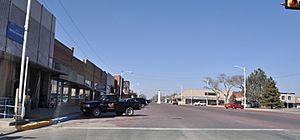
Tulia is a city in Texas, United States. It is the main town, or "county seat," of Swisher County. In 2020, about 4,473 people lived there. This was a bit less than the 4,967 people who lived there in 2010.
Tulia is located where two important roads meet: U.S. Route 87 and Texas State Highway 86. It's also close to Interstate 27. This city is a busy place for farming and other businesses related to agriculture.
Contents
A Look Back: Tulia's History
The area where Tulia now stands was once part of a large ranch called the JA Ranch. In 1887, a post office was set up about 9 miles west of today's city. It was meant to be named "Tule" after a nearby creek. But, because of a clerk's mistake, the name became "Tulia."
By 1900, Tulia was growing. It was a useful stop for wagons carrying goods to train stations in Colorado City and Amarillo. A new and exciting time began when the Santa Fe train line reached Tulia in December 1906. This brought even more people to settle in the area. In the mid-1980s, factories in Tulia made things like clothes and farm tools. There were also four big cattle farms nearby.
Where is Tulia? Geography and Climate
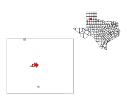
Tulia is located in the Texas Panhandle, about 46 miles south of Amarillo. According to the United States Census Bureau, the city covers about 3.5 square miles of land.
Tulia's Weather: Climate Overview
Tulia has a semiarid climate. This means it's usually dry, but not a desert.
Record Cold in Tulia
Tulia holds the record for the coldest temperature ever recorded in Texas. It was -23 degrees Fahrenheit (-30.6 degrees Celsius). This happened during a very big snowstorm in 1899, known as the Great Blizzard of 1899. The same low temperature was also recorded in Seminole, Texas, in 1933.
The average high temperature in July is around 91.1°F (32.8°C), and the average low in January is about 22.7°F (-5.2°C). Tulia gets about 20 inches (508 mm) of rain each year. It also gets some snow, with an average of 2.5 inches (6.4 cm) in January.
Who Lives in Tulia? Population Facts
| Historical population | |||
|---|---|---|---|
| Census | Pop. | %± | |
| 1910 | 1,216 | — | |
| 1920 | 1,189 | −2.2% | |
| 1930 | 2,202 | 85.2% | |
| 1940 | 2,055 | −6.7% | |
| 1950 | 3,222 | 56.8% | |
| 1960 | 4,410 | 36.9% | |
| 1970 | 5,294 | 20.0% | |
| 1980 | 5,033 | −4.9% | |
| 1990 | 4,699 | −6.6% | |
| 2000 | 5,117 | 8.9% | |
| 2010 | 4,967 | −2.9% | |
| 2020 | 4,473 | −9.9% | |
| U.S. Decennial Census | |||
As of the 2020 United States census, 4,473 people lived in Tulia. There were 1,548 households and 947 families.
Most people in Tulia are of Hispanic or Latino background, making up about 53% of the population. About 35% are White (not Hispanic), and about 8% are Black or African American (not Hispanic).
Learning in Tulia: Education
The city of Tulia is part of the Tulia Independent School District. This district has several schools that serve students of different ages:
- Tulia High School (for grades 9–12)
- Tulia Junior High School (for grades 6–8)
- W.V. Swinburn Elementary School (for grades 3–5)
- Highland Elementary School (for younger students, from early childhood to grade 2)
All of Swisher County, where Tulia is located, is also served by Amarillo College. This college provides higher education opportunities for students in the area.
News and Media in Tulia
If you want to know what's happening in Tulia, you can read the local newspaper:
- Swisher County News
Famous Faces from Tulia
Some people who have become well-known have connections to Tulia:
- Tim Curry: He was a district attorney in Tarrant County, Texas, for many years, from 1972 to 2009.
- Marshal Dutton: He is a singer and guitarist for the band Hinder.
See also
 In Spanish: Tulia (Texas) para niños
 | Precious Adams |
 | Lauren Anderson |
 | Janet Collins |


