Tarrant County, Texas facts for kids
Quick facts for kids
Tarrant County
|
|||
|---|---|---|---|
|
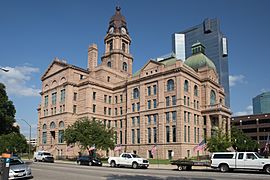
Tarrant County Courthouse
|
|||
|
|||

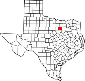
Location within the U.S. state of Texas
|
|||
 Texas's location within the U.S. |
|||
| Country | |||
| State | |||
| Founded | 1850 | ||
| Named for | Edward H. Tarrant | ||
| Seat | Fort Worth | ||
| Largest city | Fort Worth | ||
| Area | |||
| • Total | 902 sq mi (2,340 km2) | ||
| • Land | 864 sq mi (2,240 km2) | ||
| • Water | 39 sq mi (100 km2) 4.3% | ||
| Population
(2020)
|
|||
| • Total | 2,110,640 | ||
| • Estimate
(2023)
|
2,182,947 |
||
| • Density | 2,340.0/sq mi (903.5/km2) | ||
| Time zone | UTC−6 (Central) | ||
| • Summer (DST) | UTC−5 (CDT) | ||
| Congressional districts | 6th, 12th, 24th, 25th, 30th, 33rd | ||
Tarrant County is a large county in the state of Texas. It is home to over 2.1 million people, making it the third-most populated county in Texas. It is also the 15th most populated county in the entire United States. The main city and center of government for Tarrant County is Fort Worth.
Tarrant County was created in 1849 and officially started in 1850. It was one of 26 counties formed from the Peters Colony. The county is named after Edward H. Tarrant, who was a lawyer, politician, and a leader in the local militia.
Long ago, the land of Tarrant County was home to several Native American tribes. These included the Caddo, Tonkawa, Comanche, and Cherokee peoples. They bravely fought to protect their lands from new settlers. A famous battle, the Battle of Village Creek, took place here.
Contents
Geography and Location

Tarrant County covers about 902 square miles. Most of this area, about 864 square miles, is land. The remaining 39 square miles, which is about 4.3%, is water.
Neighboring Counties
Tarrant County shares its borders with several other counties:
- Denton County (to the north)
- Dallas County (to the east)
- Ellis County (to the southeast)
- Johnson County (to the south)
- Parker County (to the west)
- Wise County (to the northwest)
Cities and Towns
Tarrant County has many cities and towns. Some of these communities are so large that they stretch into neighboring counties.
Major Cities
- Fort Worth (the county seat and largest city)
- Arlington
- Grand Prairie (partly in Dallas and Ellis counties)
- Grapevine (partly in Dallas and Denton counties)
- Mansfield (partly in Ellis and Johnson counties)
- Southlake (partly in Denton County)
Other Cities and Towns
- Azle
- Bedford
- Benbrook
- Blue Mound
- Burleson
- Colleyville
- Crowley
- Dalworthington Gardens
- Edgecliff Village
- Euless
- Everman
- Flower Mound
- Forest Hill
- Haltom City
- Haslet
- Hurst
- Keller
- Kennedale
- Lake Worth
- Lakeside
- Newark
- North Richland Hills
- Pantego
- Pelican Bay
- Reno
- Richland Hills
- River Oaks
- Roanoke
- Saginaw
- Sansom Park
- Trophy Club
- Watauga
- Westlake
- Westover Hills
- Westworth Village
- White Settlement
Population Changes
| Historical population | |||
|---|---|---|---|
| Census | Pop. | %± | |
| 1850 | 664 | — | |
| 1860 | 6,020 | 806.6% | |
| 1870 | 5,788 | −3.9% | |
| 1880 | 24,671 | 326.2% | |
| 1890 | 41,142 | 66.8% | |
| 1900 | 52,376 | 27.3% | |
| 1910 | 108,572 | 107.3% | |
| 1920 | 152,800 | 40.7% | |
| 1930 | 197,553 | 29.3% | |
| 1940 | 225,521 | 14.2% | |
| 1950 | 361,253 | 60.2% | |
| 1960 | 538,495 | 49.1% | |
| 1970 | 716,317 | 33.0% | |
| 1980 | 860,880 | 20.2% | |
| 1990 | 1,170,103 | 35.9% | |
| 2000 | 1,446,219 | 23.6% | |
| 2010 | 1,809,034 | 25.1% | |
| 2020 | 2,110,623 | 16.7% | |
| 2023 (est.) | 2,182,947 | 20.7% | |
| U.S. Decennial Census 1850–2010 2010–2019 |
|||
Tarrant County has grown a lot since 1850, when only 664 people lived there. The population has steadily increased over the years. By 1990, over 1.1 million people called Tarrant County home. In 2020, the population reached 2,110,640.
Tarrant County is the second-largest county by population in the Dallas-Fort Worth area. Only Dallas County has more people.
Diversity in Tarrant County
The people living in Tarrant County come from many different backgrounds. This makes the county a very diverse place.
In 2020, the population was made up of:
- 42.87% non-Hispanic white people
- 29.42% Hispanic or Latino people (of any race)
- 16.99% Black or African American people
- 6.05% Asian people
- 0.33% American Indian and Alaska Native people
- 0.20% Pacific Islander people
- 3.74% people of two or more races
This mix of cultures shows how much Texas is becoming more diverse.
Education
Tarrant County offers many choices for education, from colleges to public and private schools.
Colleges and Universities
Tarrant County College is a major college serving the entire county. There are also several universities:
- University of Texas at Arlington
- Texas Christian University (in Fort Worth)
Schools for Kids
Public schools in Texas are managed by independent school districts and charter schools. Tarrant County also has many private schools for all age groups.
Public School Districts
Here are some of the school districts that serve students in Tarrant County:
- Arlington Independent School District
- Birdville Independent School District
- Carroll Independent School District
- Castleberry Independent School District
- Eagle Mountain-Saginaw Independent School District
- Everman Independent School District
- Fort Worth Independent School District
- Grapevine-Colleyville Independent School District
- Hurst-Euless-Bedford Independent School District
- Keller Independent School District
- Kennedale Independent School District
- Lake Worth Independent School District
- White Settlement Independent School District
- Aledo Independent School District (part of it)
- Azle Independent School District (part of it)
- Burleson Independent School District (part of it)
- Crowley Independent School District (part of it)
- Godley Independent School District (part of it)
- Lewisville Independent School District (part of it)
- Mansfield Independent School District (part of it)
- Northwest Independent School District (part of it)
Charter Schools
Charter schools are public schools that have more freedom in how they operate. Some in Tarrant County include:
- Arlington Classics Academy
- Fort Worth Academy of Fine Arts
- IDEA Public Schools
- Harmony Public Schools
- Newman International Academy
- Texas School of the Arts
- Treetops School International
- Uplift Education
- Westlake Academy
Private Schools
Private schools are also an option for families in the county. Some examples are:
- Colleyville Covenant Christian Academy
- Fort Worth Christian School
- Fort Worth Country Day School
- Lake Country Christian School
- Nolan Catholic High School
- The Oakridge School
- Southwest Christian School
- Temple Christian School
- Trinity Baptist Temple Academy
- Trinity Valley School
Getting Around: Transportation
Tarrant County has a network of highways and airports that help people travel easily.
Main Highways
Many important highways run through Tarrant County, connecting it to other parts of Texas and the country. These include:
 I-20
I-20 I-30
I-30 I-35W
I-35W I-635
I-635 I-820
I-820 US 81
US 81 US 287


 Bus. US 287
 US 377
 SH 10
SH 10 SH 26
SH 26 SH 97
SH 97 SH 114
 SH 121
 FM 156
 FM 157
 SH 161
 SH 170
 SH 180
 SH 183
 SH 303
 SH 360
Airports
Tarrant County is home to several airports, making air travel and shipping easy.
- Dallas/Fort Worth International Airport: This huge airport is partly in Tarrant County (Grapevine and Euless) and partly in Dallas County (Irving).
- Fort Worth Alliance Airport: This airport is known as the world's first airport built just for industrial use. It's located north of Fort Worth.
- Fort Worth Meacham International Airport: This airport is in northwest Fort Worth and has two runways.
- Fort Worth Spinks Airport: Located south of downtown Fort Worth, this airport helps take some of the air traffic away from the larger Meacham and DFW airports.
See also
 In Spanish: Condado de Tarrant para niños
 | DeHart Hubbard |
 | Wilma Rudolph |
 | Jesse Owens |
 | Jackie Joyner-Kersee |
 | Major Taylor |


