
Parker County, Texas facts for kids
Quick facts for kids
Parker County
|
||
|---|---|---|
.jpg)
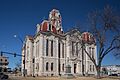
The Parker County courthouse in Weatherford
|
||
|
||

Location within the U.S. state of Texas
|
||
 Texas's location within the U.S. |
||
| Country | ||
| State | ||
| Founded | 1856 | |
| Named for | Isaac Parker, Texas legislator | |
| Seat | Weatherford | |
| Largest city | Weatherford | |
| Area | ||
| • Total | 910 sq mi (2,400 km2) | |
| • Land | 903 sq mi (2,340 km2) | |
| • Water | 6.6 sq mi (17 km2) 0.7% | |
| Population
(2020)
|
||
| • Total | 148,222 |
|
| • Density | 160/sq mi (60/km2) | |
| Time zone | UTC−6 (Central) | |
| • Summer (DST) | UTC−5 (CDT) | |
| Congressional districts | 12th, 25th | |

Parker County is a county in the U.S. state of Texas. In 2020, about 148,222 people lived there. The main city and government center is Weatherford.
The county was created in 1855. It was named after Isaac Parker. He was a state lawmaker who helped create the county. Parker County is part of the larger Dallas-Fort Worth-Arlington area. This area is also known as the Dallas/Fort Worth Metroplex.
Contents
Geography of Parker County
Parker County covers about 910 square miles. Most of this area is land. Only a small part, about 0.7%, is water. The Brazos River flows through the county.
Highest Point
The highest points in Parker County are Slipdown Mountain and Slipdown Bluff. They are about 1,368 feet (417 meters) tall. You can find them near the Advance community, southwest of Poolville.
Main Roads
Several important roads cross Parker County. These roads help people travel easily through the area.
 I-20
I-20 I-30
I-30 US 180
 US 377
 SH 171
 SH 199
Neighboring Counties
Parker County shares its borders with several other counties:
- Wise County (to the north)
- Tarrant County (to the east)
- Johnson County (to the southeast)
- Hood County (to the south)
- Palo Pinto County (to the west)
- Jack County (to the northwest)
Communities in Parker County
Parker County has many different towns and cities. Some of these communities are also in other counties.
Cities (in multiple counties)
- Azle (mostly in Tarrant County)
- Cresson (also in Hood and Johnson counties)
- Fort Worth (mostly in Tarrant County, with small parts in Parker and other counties)
- Mineral Wells (mostly in Palo Pinto County)
- Reno (a small part is in Tarrant County)
Cities (only in Parker County)
- Aledo
- Hudson Oaks
- Weatherford (This is the county seat)
- Willow Park
Towns
Other Communities
Some areas are called census-designated places. These are like small towns but are not officially incorporated.
- Briar (also in Wise and Tarrant counties)
- Carter
- Dennis
- Garner
- Horseshoe Bend
- Western Lake
There are also unincorporated communities. These are places where people live but they don't have their own local government.
Population of Parker County
| Historical population | |||
|---|---|---|---|
| Census | Pop. | %± | |
| 1860 | 4,213 | — | |
| 1870 | 4,186 | −0.6% | |
| 1880 | 15,870 | 279.1% | |
| 1890 | 21,682 | 36.6% | |
| 1900 | 25,823 | 19.1% | |
| 1910 | 26,331 | 2.0% | |
| 1920 | 23,382 | −11.2% | |
| 1930 | 18,759 | −19.8% | |
| 1940 | 20,482 | 9.2% | |
| 1950 | 21,528 | 5.1% | |
| 1960 | 22,880 | 6.3% | |
| 1970 | 33,888 | 48.1% | |
| 1980 | 44,609 | 31.6% | |
| 1990 | 64,785 | 45.2% | |
| 2000 | 88,495 | 36.6% | |
| 2010 | 116,927 | 32.1% | |
| 2020 | 148,220 | 26.8% | |
| 2023 (est.) | 173,494 | 48.4% | |
| U.S. Decennial Census 1850–2010 2010 2020 |
|||
In 2000, Parker County had 88,495 people. By 2020, the population grew to 148,222.
According to the 2020 census, most people in Parker County were non-Hispanic white (about 79.44%). About 13.37% were Hispanic or Latino. Other groups included multiracial people (4.44%), Black or African American people (1.10%), Asian people (0.67%), Native American people (0.59%), and Pacific Islander people (0.07%).
In 2023, the U.S. Census Bureau estimated that Parker County's population was around 173,494. At that time, about 79.6% of the people were non-Hispanic White. About 15.1% were Hispanic or Latino. Other groups made up smaller percentages of the population.
Famous People from Parker County
Many interesting people have come from Parker County.
- Oliver Loving: He helped create the famous Loving-Goodnight Cattle Trail.
- Bose Ikard: He was a trusted cattle driver for Oliver Loving.
- Mary Martin: A well-known star from stage and movies.
- S.W.T. Lanham: He was the last Confederate veteran to become governor of Texas.
- Jim Wright: He was the youngest mayor of Weatherford, Texas. He also became the Speaker of the U.S. House of Representatives.
Images for kids
-

The flag of Parker County, Texas.
-
The Parker County courthouse in Weatherford.
See also
 In Spanish: Condado de Parker para niños
