Palo Pinto County, Texas facts for kids
Quick facts for kids
Palo Pinto County
|
||
|---|---|---|

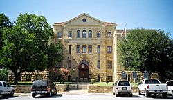
The Palo Pinto County Courthouse in Palo Pinto: The limestone structure was added to the National Register of Historic Places in 1997.
|
||
|
||

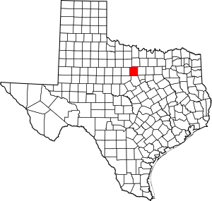
Location within the U.S. state of Texas
|
||
 Texas's location within the U.S. |
||
| Country | ||
| State | ||
| Founded | 1857 | |
| Named for | Palo Pinto Creek | |
| Seat | Palo Pinto | |
| Largest city | Mineral Wells | |
| Area | ||
| • Total | 986 sq mi (2,550 km2) | |
| • Land | 952 sq mi (2,470 km2) | |
| • Water | 34 sq mi (90 km2) 3.4% | |
| Population
(2020)
|
||
| • Total | 28,409 | |
| • Density | 28.812/sq mi (11.125/km2) | |
| Time zone | UTC−6 (Central) | |
| • Summer (DST) | UTC−5 (CDT) | |
| Congressional district | 25th | |
Palo Pinto County is a county in the state of Texas. In 2020, about 28,409 people lived there. The main town, or county seat, is Palo Pinto. The county was officially started in 1856 and set up in 1857.
Palo Pinto County is part of the Mineral Wells area. This area is also close to the bigger Dallas–Fort Worth region. The county is located in a natural area known as the western Cross Timbers.
Contents
History of Palo Pinto County

Palo Pinto County has a rich history, from its early Native American residents to its growth with ranching and the discovery of special waters.
Native American Life
In 1854, the Brazos Indian Reservation was created. It was a safe place for several Native American tribes. These included the Delaware, Shawnee, Tonkawa, Wichita, Choctaw, and Caddo people. They lived in their own villages and grew crops.
However, some people outside the reservation blamed these tribes for raids by other groups like the Comanche and Kiowa. This led to tensions. In December 1858, a group of people attacked a camp of reservation Indians. Many were hurt or killed.
Later, in May 1859, a man named John Baylor and others confronted U.S. troops at the reservation. They wanted certain tribal members. The military refused. Because of these conflicts, the reservation was closed that same year.
How the County Began
In 1856, the Texas State Legislature officially created Palo Pinto County. It was formed from parts of Bosque and Navarro Counties. The county was named after Palo Pinto Creek.
The county was organized in 1857. The town of Golconda was chosen as the first county seat. In 1858, Golconda was renamed Palo Pinto.
Early Ranching and Farming
Some of the first settlers were ranchers like Oliver Loving and Charles Goodnight. They helped create the famous Goodnight-Loving Trail. In 1876, local ranchers met to discuss cattle theft. This meeting led to the creation of the Texas and Southwestern Cattle Raisers Association.
From 1883 to 1888, Texas saw the "Fence Cutting Wars." As more farmers and ranchers moved in, land and water became scarce. Some cowboys cut fences to find food for their cattle. Texas Governor John Ireland pushed for laws against fence-cutting. The legislature made it a crime, and the problem eventually stopped.
Later Growth and Development
In 1877, James and Amanda Lynch moved to the area. While digging a well, they found water that seemed to improve their health. News spread, and people came from everywhere to try the water. This led to the creation of the town of Mineral Wells.
Later, the Texas National Guard built a training camp called Camp Wolters in 1921. In 1941, it became a United States Army base. It was used for helicopter training before closing in 1973.
Possum Kingdom Lake was created in 1940. The Civilian Conservation Corps helped build its facilities. Possum Kingdom State Park opened to the public in 1950.
Geography of Palo Pinto County
Palo Pinto County covers about 986 square miles. About 34 square miles of this area are covered by water.
Natural Features
Main Roads
 Interstate 20
 U.S. Highway 180
 U.S. Highway 281
 State Highway 16
 State Highway 108
Neighboring Counties
Palo Pinto County shares borders with several other counties:
- Jack County (north)
- Parker County (east)
- Hood County (southeast)
- Erath County (south)
- Eastland County (southwest)
- Stephens County (west)
- Young County (northwest)
People of Palo Pinto County
| Historical population | |||
|---|---|---|---|
| Census | Pop. | %± | |
| 1860 | 1,524 | — | |
| 1880 | 5,885 | — | |
| 1890 | 8,320 | 41.4% | |
| 1900 | 12,291 | 47.7% | |
| 1910 | 19,506 | 58.7% | |
| 1920 | 23,431 | 20.1% | |
| 1930 | 17,576 | −25.0% | |
| 1940 | 18,456 | 5.0% | |
| 1950 | 17,154 | −7.1% | |
| 1960 | 20,516 | 19.6% | |
| 1970 | 28,962 | 41.2% | |
| 1980 | 24,062 | −16.9% | |
| 1990 | 25,055 | 4.1% | |
| 2000 | 27,026 | 7.9% | |
| 2010 | 28,111 | 4.0% | |
| 2020 | 28,409 | 1.1% | |
| U.S. Decennial Census 1850–2010 2010 2020 |
|||
| Race / Ethnicity (NH = Non-Hispanic) | Pop 2000 | Pop 2010 | Pop 2020 | % 2000 | % 2010 | % 2020 |
|---|---|---|---|---|---|---|
| White alone (NH) | 22,163 | 21,958 | 20,778 | 82.01% | 78.11% | 73.14% |
| Black or African American alone (NH) | 617 | 597 | 552 | 2.28% | 2.12% | 1.94% |
| Native American or Alaska Native alone (NH) | 140 | 135 | 149 | 0.52% | 0.48% | 0.52% |
| Asian alone (NH) | 137 | 132 | 211 | 0.51% | 0.47% | 0.74% |
| Pacific Islander alone (NH) | 4 | 11 | 12 | 0.01% | 0.04% | 0.04% |
| Other race alone (NH) | 17 | 13 | 69 | 0.06% | 0.05% | 0.24% |
| Mixed race or Multiracial (NH) | 281 | 280 | 1,024 | 1.04% | 1.00% | 3.60% |
| Hispanic or Latino (any race) | 3,667 | 4,985 | 5,614 | 13.57% | 17.73% | 19.76% |
| Total | 27,026 | 28,111 | 28,409 | 100.00% | 100.00% | 100.00% |
In 2000, there were 27,026 people living in Palo Pinto County. There were 10,594 households and 7,447 families. The population density was about 28 people per square mile.
The people living in the county were mostly White (88.19%). There were also African American (2.32%), Native American (0.67%), and Asian (0.53%) residents. About 13.57% of the population was Hispanic or Latino.
In 2000, about 30.40% of households had children under 18. Most households (55.60%) were married couples. About 26.20% of households were individuals living alone. The average household had 2.52 people.
The median age in the county was 38 years old. About 26.0% of the population was under 18. About 16.4% was 65 or older.
Towns and Communities
Palo Pinto County has several towns and smaller communities.
Cities
- Gordon
- Graford
- Mineral Wells (partly in Parker County)
- Mingus
- Strawn
County Seat
- Palo Pinto is the county seat, which means it's where the county government is located.
Other Communities
Notable People
Some well-known people have connections to Palo Pinto County:
- Steve Tyrell, a singer and recording artist.
- Glenn Rogers, a Republican who represents District 60 in the Texas House of Representatives.
See also
 In Spanish: Condado de Palo Pinto para niños
 | William L. Dawson |
 | W. E. B. Du Bois |
 | Harry Belafonte |


