Palo Pinto, Texas facts for kids
Quick facts for kids
Palo Pinto
|
|
|---|---|

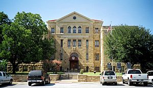
Palo Pinto County Courthouse
|
|
| Country | United States |
| State | Texas |
| County | Palo Pinto |
| Area | |
| • Total | 0.9 sq mi (2.3 km2) |
| • Land | 0.9 sq mi (2.3 km2) |
| • Water | 0.0 sq mi (0.0 km2) |
| Elevation | 1,017 ft (310 m) |
| Population
(2010)
|
|
| • Total | 333 |
| • Density | 370/sq mi (145/km2) |
| Time zone | UTC-6 (Central (CST)) |
| • Summer (DST) | UTC-5 (CDT) |
| ZIP codes |
76484
|
| Area code(s) | 940 |
| GNIS feature ID | 2584712 |
Palo Pinto is a small community in Palo Pinto County, Texas, United States. It is the main town where the county government is located. In 2010, about 333 people lived here. It's known as a census-designated place (CDP), which means it's an area identified by the United States Census Bureau for statistics.
Contents
Where is Palo Pinto?
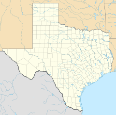
Palo Pinto is located in Texas, at these coordinates: 32°46′9″N 98°18′3″W / 32.76917°N 98.30083°W. The community covers an area of about 0.9 square miles (2.3 square kilometers). All of this area is land, with no large bodies of water.
A Look at Palo Pinto's Past
Palo Pinto County was officially created in 1856. The plan was to build a community near the center of the county to be its main town. This town would serve as the seat of government.
In May 1857, the county was formally set up. On August 18 of that year, the first county court meeting happened. They discussed and approved plans for the new county seat.
The community was first called Golconda. It was laid out soon after the court meeting. In March 1858, it got its own post office. Around this time, the town and its post office were renamed Palo Pinto.
Early Buildings and Businesses
The very first Palo Pinto County Courthouse was built in 1857. A two-story stone jail was also built shortly after. By 1860, Palo Pinto had grown quite a bit. It had a hotel, a law firm, several places to eat and drink, and its own school.
However, the American Civil War (1861-1865) made things difficult for businesses. Many had to close down. After the war, Palo Pinto became a place where local ranchers would ship their goods.
The county's first newspaper started in 1876. Throughout the 1870s, Palo Pinto remained the most important town in the county. It was the center for government and business.
Changes and Growth
In 1880, the Texas and Pacific Railway was built, but it bypassed Palo Pinto. This meant the town didn't get a train station, which usually helps towns grow. Even so, Palo Pinto's population stayed above 400 people. It also kept several businesses.
Palo Pinto is still the county seat today. However, another town called Mineral Wells grew much larger many years ago. The current Palo Pinto County Courthouse, which is on US 180 in the middle of town, was built in 1940.
The town's population reached its highest point of 550 people in 1947. After that, it went down to around 400 people. It has stayed around that number ever since.
Who Lives in Palo Pinto?
| Historical population | |||
|---|---|---|---|
| Census | Pop. | %± | |
| 2020 | 276 | — | |
| U.S. Decennial Census 1850–1900 1910 1920 1930 1940 1950 1960 1970 1980 1990 2000 2010 |
|||
2020 Census Information
The 2020 United States census counted 276 people living in Palo Pinto. There were 41 households and 37 families in the community.
Here's a breakdown of the different groups of people living in Palo Pinto in 2020:
| Race | Number | Percentage |
|---|---|---|
| White (NH) | 207 | 75.0% |
| Black or African American (NH) | 6 | 2.17% |
| Native American or Alaska Native (NH) | 2 | 0.72% |
| Asian (NH) | 5 | 1.81% |
| Pacific Islander (NH) | 1 | 0.36% |
| Some Other Race (NH) | 1 | 0.36% |
| Mixed/Multi-Racial (NH) | 7 | 2.54% |
| Hispanic or Latino | 47 | 17.03% |
| Total | 276 |
Schools in Palo Pinto
Children in Palo Pinto attend schools from three different school districts.
- Kids from prekindergarten up to sixth grade go to the Palo Pinto ISD school.
- Students in seventh through 12th grade attend schools in either the Gordon ISD or the Mineral Wells ISD.
Palo Pinto's Climate
Palo Pinto has a climate known as humid subtropical. This means the area has relatively high temperatures. It also gets rain spread out fairly evenly throughout the year. The Köppen climate classification system describes this as Cfa.
See also
 In Spanish: Palo Pinto (Texas) para niños
 | James Van Der Zee |
 | Alma Thomas |
 | Ellis Wilson |
 | Margaret Taylor-Burroughs |


