Young County, Texas facts for kids
Quick facts for kids
Young County
|
|
|---|---|

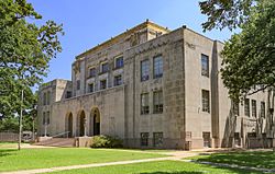
The Young County Courthouse in Graham
|
|

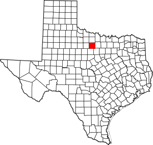
Location within the U.S. state of Texas
|
|
 Texas's location within the U.S. |
|
| Country | |
| State | |
| Founded | 1874 |
| Named for | William Cocke Young |
| Seat | Graham |
| Largest city | Graham |
| Area | |
| • Total | 931 sq mi (2,410 km2) |
| • Land | 914 sq mi (2,370 km2) |
| • Water | 16 sq mi (40 km2) 1.8% |
| Population
(2020)
|
|
| • Total | 17,867 |
| • Density | 19.191/sq mi (7.410/km2) |
| Time zone | UTC−6 (Central) |
| • Summer (DST) | UTC−5 (CDT) |
| Congressional district | 25th |
Young County is a county located in the state of Texas. In 2020, about 17,867 people lived there. Its main town, or county seat, is Graham. The county was created in 1856 and officially started its government in 1874. It is named after William Cocke Young, who was an early Texas settler and soldier.
Contents
History of Young County
Native American Life
In 1854, the Brazos Indian Reservation was created by General Randolph B. Marcy. This place became a safe home for several Native American groups. These included the Delaware, Shawnee, Tonkawa, Wichita, Choctaw, and Caddo peoples. They had moved to Texas from other areas.
On the reservation, each tribe had its own village. They grew their own crops for food. The government also provided beef cattle each week. However, many settlers found it hard to tell the difference between reservation tribes and other tribes. They often blamed the reservation Indians for raids by the Comanche and Kiowa tribes. A newspaper in Jacksboro, Texas, called The White Man, even suggested removing all tribes from North Texas.
In December 1858, a group of reservation Indians, including Choctaw Tom, went hunting outside the reservation. Choctaw Tom was a Yowani man married to a Hasinai woman. He sometimes worked as an interpreter for Sam Houston. On December 27, a group of settlers led by Captain Peter Garland attacked Choctaw Tom's camp. They harmed many people, including women and children.
After this attack, Governor Hardin Richard Runnels sent Major John Henry Brown and 100 state troops to the area. They were there to prevent more trouble. An investigation was held about the attack on Choctaw Tom's camp, but no one was charged.
In May 1859, John Baylor led a group of white settlers who faced off against United States troops. The troops were protecting the reservation. Baylor's group wanted the troops to hand over certain tribal members. They believed these individuals were involved in raids. The military refused. Baylor's group left, but they harmed an Indian woman and an old man on their way. Later, Baylor's group was attacked by Indians who were not on the reservation. The military could not get involved in that situation.
In May 1871, several Kiowa leaders, including Satank (Sitting Bear), Satanta (White Bear), Addo-etta (Big Tree), and Maman-ti (Skywalker), led over 100 warriors. These warriors were from the Oklahoma Fort Sill Reservation. They were Kiowa, Comanche, Kiowa-Apaches, Arapaho, and Cheyenne. On May 18, they attacked a wagon train belonging to Henry Warren. Most of the people were killed, but five managed to escape.
The main general of the United States Army, William Tecumseh Sherman, personally arrested Satank, Satanta, and Big Tree at Fort Sill. They were put on trial in Jacksboro. Satank was killed while trying to escape. The others were found guilty. Their sentences were later changed by Governor Edmund J. Davis after a group of Quakers asked him to. They were later released. This event was an important part of what led to the Red River War.
Early Explorers and Settlers
Spanish Colonel Diego Ortiz Parrilla traveled through the county in 1759. He was on his way to the Red River Campaign. Pedro Vial also came through the area in 1789 while mapping the Santa Fe Trail.
In 1841, the Republic of Texas gave a large land grant called Peters Colony. This grant included the area that would become Young County. However, the Young County part of the grant remained unsettled until the 1850s.
In 1851, General William G. Belknap started United States Army Fort Belknap. This fort was given to the Confederacy in 1861 during the Civil War. Federal troops took it back in 1867. John and Will Peveler were the first settlers. They built a ranch about 2 miles (3.2 km) below Fort Belknap.
How Young County Was Formed
The Texas Legislature officially created Young County in 1856. It was formed from parts of Bosque and Fannin Counties. Later that year, the county government was set up. Belknap became the first county seat.
Many people left the area during the American Civil War. This was because of attacks by Native Americans. In 1865, the county's government stopped working. The county records were moved to Jacksboro.
The county government started up again in 1874. The records were brought back from Jacksboro. This time, a new town called Graham was chosen as the county seat. Graham had been planned out in 1873.
Gustavus and Edwin Graham started the town of Graham in 1872. They also opened a saltworks in 1869. In 1876, ranchers met in Graham to talk about cattle theft. This meeting was the beginning of what is now the Texas and Southwestern Cattle Raisers Association. In 1891, a group of investors created the Graham Mining Company. They hoped to find gold, silver, and coal in the area.
Between 1874 and 1910, railroads helped the county's economy. They made transportation easier. These railroads included the Chicago, Rock Island and Gulf Railway, the Wichita Falls and Southern, and the Gulf, Texas and Western Railroad.
During the Great Depression, federal programs helped farmers and ranchers. The Work Projects Administration helped restore old Fort Belknap in 1936. In the 1930s, Young County also joined 65 other counties. They formed the Brazos River Conservation and Reclamation District.
Oil exploration and production began in the early 1900s. The Lindy Lou No. 1 well was a big discovery. Actual petroleum production started in 1920. This led to many new towns popping up around the county. By 1990, about 3,431,000 barrels of oil had been produced.
Geography of Young County
Young County covers a total area of about 931 square miles (2,410 km²). Most of this, about 914 square miles (2,367 km²), is land. The remaining 16 square miles (41 km²) is covered by water. This means about 1.8% of the county is water.
Main Roads
Neighboring Counties
Young County shares borders with these other counties:
- Archer County (to the north)
- Jack County (to the east)
- Palo Pinto County (to the southeast)
- Stephens County (to the south)
- Throckmorton County (to the west)
People of Young County
| Historical population | |||
|---|---|---|---|
| Census | Pop. | %± | |
| 1860 | 592 | — | |
| 1870 | 135 | −77.2% | |
| 1880 | 4,726 | 3,400.7% | |
| 1890 | 5,049 | 6.8% | |
| 1900 | 6,540 | 29.5% | |
| 1910 | 13,657 | 108.8% | |
| 1920 | 13,379 | −2.0% | |
| 1930 | 20,128 | 50.4% | |
| 1940 | 19,004 | −5.6% | |
| 1950 | 16,810 | −11.5% | |
| 1960 | 17,254 | 2.6% | |
| 1970 | 15,400 | −10.7% | |
| 1980 | 19,001 | 23.4% | |
| 1990 | 18,126 | −4.6% | |
| 2000 | 17,943 | −1.0% | |
| 2010 | 18,550 | 3.4% | |
| 2020 | 17,867 | −3.7% | |
| U.S. Decennial Census 1850–2010 2010 2020 |
|||
| Race / Ethnicity (NH = Non-Hispanic) | Pop 2010 | Pop 2020 | % 2010 | % 2020 |
|---|---|---|---|---|
| White alone (NH) | 14,959 | 13,409 | 80.64% | 75.05% |
| Black or African American alone (NH) | 220 | 174 | 1.19% | 0.97% |
| Native American or Alaska Native alone (NH) | 83 | 79 | 0.45% | 0.44% |
| Asian alone (NH) | 55 | 86 | 0.30% | 0.48% |
| Pacific Islander alone (NH) | 5 | 0 | 0.03% | 0.00% |
| Other race alone (NH) | 4 | 38 | 0.02% | 0.21% |
| Mixed race or Multiracial (NH) | 179 | 573 | 0.96% | 3.21% |
| Hispanic or Latino (any race) | 3,045 | 3,508 | 16.42% | 19.63% |
| Total | 18,550 | 17,867 | 100.00% | 100.00% |
In 2000, there were 17,943 people living in Young County. There were 7,167 households and 5,081 families. The county had about 20 people per square mile (7.7/km²). There were 8,504 housing units, with about 9 units per square mile (3.5/km²).
The people in the county were mostly White (90.98%). About 1.21% were Black, and 0.64% were Native American. About 0.26% were Asian, and 0.04% were Pacific Islander. About 5.28% were from other races, and 1.58% were from two or more races. About 10.62% of the population was Hispanic or Latino.
Of the households, 30.80% had children under 18 living with them. About 58.00% were married couples. Around 9.40% had a female head of household with no husband. About 29.10% were not families.
About 26.30% of all households were made up of individuals. And 14.30% had someone living alone who was 65 years or older. The average household had 2.45 people. The average family had 2.94 people.
The population's age breakdown was:
- 25.00% under 18 years old
- 7.00% from 18 to 24
- 24.70% from 25 to 44
- 23.60% from 45 to 64
- 19.70% who were 65 years or older
The average age was 41 years. For every 100 females, there were about 91.60 males. For every 100 females aged 18 and over, there were about 86.70 males.
The average income for a household in the county was $30,499. For a family, it was $36,698. Men earned an average of $30,257, while women earned $19,441. The average income per person in the county was $16,710. About 12.00% of families and 15.70% of the total population lived below the poverty line. This included 21.00% of those under 18 and 12.90% of those 65 or older.
Communities in Young County
Cities
Unincorporated Communities
These are smaller communities that do not have their own city government:
Education in Young County
Several school districts serve different parts of Young County:
- Bryson Independent School District
- Graham Independent School District
- Newcastle Independent School District
- Olney Independent School District
- Woodson Independent School District
The Megargel Independent School District used to serve a part of the county. However, the Megargel schools closed in 2006.
Most of Young County is in the area served by Ranger Junior College. Areas within the Graham Independent School District are also part of the service area for North Central Texas College.
See also
 In Spanish: Condado de Young para niños
 | Sharif Bey |
 | Hale Woodruff |
 | Richmond Barthé |
 | Purvis Young |

