Throckmorton County, Texas facts for kids
Quick facts for kids
Throckmorton County
|
|
|---|---|

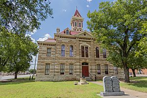
The Throckmorton County Courthouse
|
|

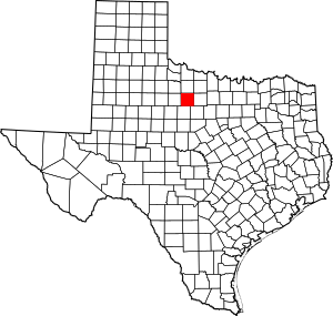
Location within the U.S. state of Texas
|
|
 Texas's location within the U.S. |
|
| Country | |
| State | |
| Founded | 1879 |
| Named for | William Throckmorton |
| Seat | Throckmorton |
| Largest town | Throckmorton |
| Area | |
| • Total | 915 sq mi (2,370 km2) |
| • Land | 913 sq mi (2,360 km2) |
| • Water | 2.9 sq mi (8 km2) 0.3% |
| Population
(2020)
|
|
| • Total | 1,440 |
| • Density | 1.574/sq mi (0.6076/km2) |
| Time zone | UTC−6 (Central) |
| • Summer (DST) | UTC−5 (CDT) |
| Congressional district | 19th |
Throckmorton County is a county in the state of Texas. In 2020, about 1,440 people lived here. Its main town, or county seat, is Throckmorton.
The county was created in 1858 and officially started working in 1879. It is named after William Throckmorton, an early settler in Collin County. Throckmorton County is one of the few counties in Texas where selling alcohol is still not allowed.
Contents
History of Throckmorton County
The first European to travel through what is now Throckmorton County was a Spanish explorer named Pedro Vial. He passed through in 1786. He was looking for a direct path between San Antonio and Santa Fe.
Later, in 1849, Captain Randolph B. Marcy of the U.S. military explored the area. In 1837, the Republic of Texas had already created Fannin County, which included this land.
Throckmorton County was officially formed in 1858. The town of Williamsburg was first chosen as the county seat. The county was named for Dr. William E. Throckmorton. He was an early pioneer in North Texas and the father of James W. Throckmorton, who later became the governor of Texas. The county government officially began in 1879, and Throckmorton became the county seat.
In 1854, Captain Marcy returned to find good places for Native American reservations. He set up the Comanche Indian Reservation near the Clear Fork of the Brazos River. This area had plenty of water and good hunting. In 1855, the Comanche Indians began moving to the reservation.
To protect the reservation, Camp Cooper was built in 1856. Captain Robert E. Lee was in charge of the camp for a time. In 1859, the people living on the Comanche Indian Reservation were moved to Oklahoma. Camp Cooper was closed by federal troops in 1861, just before the Civil War began.
Before the Civil War, some settlers moved into the county near Camp Cooper. When the camp closed, most settlers moved east for safety from the Comanche Indians.
In 1858, the Butterfield Overland Mail stage line started operating. It had two stops in Throckmorton County. These were Franz's Station and Clear Fork of the Brazos station.
After the Civil War, Fort Griffin was built in 1867. With soldiers in the area, many old settlers came back. New settlers also arrived. They often settled near the Clear Fork, where there was lots of wildlife. Huge herds of buffalo lived there, and buffalo hunters used Fort Griffin as their base.
The first settlers were cattle ranchers. They used the open land and moved cattle north along the Great Western Cattle Trail. Later, farmers moved in and started farming on smaller pieces of land. Federal troops left Fort Griffin in 1881. This marked the end of the frontier era in the region.
Glenn Reynolds was the first sheriff of Throckmorton County. He later moved to Arizona. In 1889, he and another deputy were killed by prisoners they were transporting.
Geography
The U.S. Census Bureau says the county covers about 915 square miles. Most of this (913 square miles) is land. About 2.9 square miles (0.3%) is water.
Major roads
Neighboring counties
- Baylor County (north)
- Young County (east)
- Stephens County (southeast)
- Shackelford County (south)
- Haskell County (west)
- Archer County (northeast)
- Knox County (northwest)
Population Information
| Historical population | |||
|---|---|---|---|
| Census | Pop. | %± | |
| 1860 | 124 | — | |
| 1880 | 711 | — | |
| 1890 | 902 | 26.9% | |
| 1900 | 1,750 | 94.0% | |
| 1910 | 4,563 | 160.7% | |
| 1920 | 3,589 | −21.3% | |
| 1930 | 5,253 | 46.4% | |
| 1940 | 4,275 | −18.6% | |
| 1950 | 3,618 | −15.4% | |
| 1960 | 2,767 | −23.5% | |
| 1970 | 2,205 | −20.3% | |
| 1980 | 2,053 | −6.9% | |
| 1990 | 1,880 | −8.4% | |
| 2000 | 1,850 | −1.6% | |
| 2010 | 1,641 | −11.3% | |
| 2020 | 1,440 | −12.2% | |
| 2021 (est.) | 1,495 | −8.9% | |
| U.S. Decennial Census 1850–2010 2010 2020 |
|||
In 2010, 1,641 people lived in Throckmorton County. The population has changed over the years, as shown in the table above.
In 2000, there were 1,850 people living in the county. About 29.2% of households had children under 18. The average household had 2.39 people. The average family had 2.92 people.
The median age in the county was 42 years old. This means half the people were younger than 42 and half were older.
Communities
Towns, Villages and Hamlets
- Throckmorton (county seat)
- Elbert
- Woodson
Census-designated place
Education
Several school districts serve different parts of Throckmorton County:
- Munday Consolidated Independent School District
- Olney Independent School District
- Throckmorton Collegiate Independent School District
- Woodson Independent School District
Some school districts have merged over time. For example, Goree Independent School District joined Munday CISD in 2003. Megargel Independent School District also used to serve the county but closed its schools in 2006.
The county is also served by Vernon College, which offers higher education.
See also
 In Spanish: Condado de Throckmorton para niños
 | Misty Copeland |
 | Raven Wilkinson |
 | Debra Austin |
 | Aesha Ash |

