Shackelford County, Texas facts for kids
Quick facts for kids
Shackelford County
|
|
|---|---|

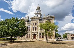
The Shackelford County Courthouse in Albany
|
|

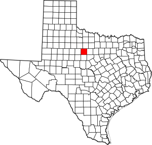
Location within the U.S. state of Texas
|
|
 Texas's location within the U.S. |
|
| Country | |
| State | |
| Founded | 1874 |
| Named for | Jack Shackelford |
| Seat | Albany |
| Largest city | Albany |
| Area | |
| • Total | 916 sq mi (2,370 km2) |
| • Land | 914 sq mi (2,370 km2) |
| • Water | 1.3 sq mi (3 km2) 0.1% |
| Population
(2020)
|
|
| • Total | 3,105 |
| • Density | 3.3897/sq mi (1.3088/km2) |
| Time zone | UTC−6 (Central) |
| • Summer (DST) | UTC−5 (CDT) |
| Congressional district | 19th |
Shackelford County is a county located in the state of Texas in the United States. In 2020, about 3,105 people lived there. The main town and county seat is Albany. The county was officially created in 1858 and started its government in 1874. It is named after Dr. Jack Shackelford. He was a doctor from Virginia who helped soldiers fight in the Texas Revolution by paying for their equipment himself.
A historic place called Fort Griffin is located in Shackelford County. It was built in 1867.
Every year, during the last two weekends of June, a special outdoor musical show takes place in Albany. It is called the Fort Griffin Fandangle. People from Shackelford County perform this western musical. The story of the show changes each year. It started in 1938 and is known as "Texas' Oldest Outdoor Musical."
Contents
Geography of Shackelford County
Shackelford County covers a total area of about 916 square miles. Most of this area, 914 square miles, is land. Only a small part, about 1.3 square miles, is water.
Main Roads
Neighboring Counties
Shackelford County shares borders with these other counties:
- Throckmorton County (to the north)
- Stephens County (to the east)
- Eastland County (to the southeast)
- Callahan County (to the south)
- Jones County (to the west)
- Haskell County (to the northwest)
- Taylor County (to the southwest)
Population Changes
| Historical population | |||
|---|---|---|---|
| Census | Pop. | %± | |
| 1860 | 44 | — | |
| 1870 | 455 | 934.1% | |
| 1880 | 2,037 | 347.7% | |
| 1890 | 2,012 | −1.2% | |
| 1900 | 2,461 | 22.3% | |
| 1910 | 4,201 | 70.7% | |
| 1920 | 4,960 | 18.1% | |
| 1930 | 6,695 | 35.0% | |
| 1940 | 6,211 | −7.2% | |
| 1950 | 5,001 | −19.5% | |
| 1960 | 3,990 | −20.2% | |
| 1970 | 3,323 | −16.7% | |
| 1980 | 3,915 | 17.8% | |
| 1990 | 3,316 | −15.3% | |
| 2000 | 3,302 | −0.4% | |
| 2010 | 3,378 | 2.3% | |
| 2020 | 3,105 | −8.1% | |
| U.S. Decennial Census 1850–2010 2010 2020 |
|||
In 2000, there were 3,302 people living in Shackelford County. The county had about 4 people per square mile.
Education
Students in Shackelford County attend schools in these districts:
- Lueders-Avoca Independent School District
- Albany Independent School District
- Moran Independent School District
Towns and Communities
- Albany (This is the county seat, where the main government offices are.)
- Lueders (Most of this town is in Jones County.)
- Moran
See also
 In Spanish: Condado de Shackelford para niños
 | Leon Lynch |
 | Milton P. Webster |
 | Ferdinand Smith |


