
Stephens County, Texas facts for kids
Quick facts for kids
Stephens County
|
|
|---|---|

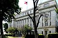
The Stephens County Courthouse in Breckenridge
|
|

Location within the U.S. state of Texas
|
|
 Texas's location within the U.S. |
|
| Country | |
| State | |
| Founded | 1876 |
| Named for | Alexander H. Stephens |
| Seat | Breckenridge |
| Largest city | Breckenridge |
| Area | |
| • Total | 921 sq mi (2,390 km2) |
| • Land | 897 sq mi (2,320 km2) |
| • Water | 25 sq mi (60 km2) 2.7% |
| Population
(2020)
|
|
| • Total | 9,101 |
| • Density | 9.882/sq mi (3.8153/km2) |
| Time zone | UTC−6 (Central) |
| • Summer (DST) | UTC−5 (CDT) |
| Congressional district | 25th |
Stephens County is a special area of land in the state of Texas, USA. It is like a local government area. In 2020, about 9,101 people lived there. The main town, or county seat, where the county government is located, is Breckenridge.
Stephens County was first created in 1858 and officially started working in 1876. It was first called Buchanan County, named after U.S. President James Buchanan. But in 1861, its name was changed to honor Alexander H. Stephens. He was an important leader during the American Civil War, serving as the vice president of the Confederate States of America.
Contents
Exploring Stephens County's Geography
Stephens County covers a total area of about 921 square miles. Most of this area, about 897 square miles, is land. The rest, about 25 square miles, is covered by water, like lakes or rivers.
Main Roads in Stephens County
These are the most important roads that help people travel through Stephens County:
 U.S. Highway 180
 U.S. Highway 183
 State Highway 67
Neighboring Counties
Stephens County shares its borders with several other counties:
- Young County is to the north.
- Palo Pinto County is to the east.
- Eastland County is to the south.
- Shackelford County is to the west.
- Throckmorton County is to the northwest.
Who Lives in Stephens County?
The number of people living in Stephens County has changed over many years. Here's a quick look at how the population has grown and shrunk:
| Historical population | |||
|---|---|---|---|
| Census | Pop. | %± | |
| 1860 | 230 | — | |
| 1870 | 330 | 43.5% | |
| 1880 | 4,725 | 1,331.8% | |
| 1890 | 4,926 | 4.3% | |
| 1900 | 6,466 | 31.3% | |
| 1910 | 7,980 | 23.4% | |
| 1920 | 15,403 | 93.0% | |
| 1930 | 16,560 | 7.5% | |
| 1940 | 12,356 | −25.4% | |
| 1950 | 10,597 | −14.2% | |
| 1960 | 8,885 | −16.2% | |
| 1970 | 8,414 | −5.3% | |
| 1980 | 9,926 | 18.0% | |
| 1990 | 9,010 | −9.2% | |
| 2000 | 9,674 | 7.4% | |
| 2010 | 9,630 | −0.5% | |
| 2020 | 9,101 | −5.5% | |
| U.S. Decennial Census 1850–2010 2010 2020 |
|||
In the year 2000, there were 9,674 people living in Stephens County. About 3,661 homes were counted. The average number of people in each home was about 2.47.
Many different groups of people make up the population of Stephens County. In 2000, most people (about 86.89%) were White. There were also people who identified as Black or African American (2.92%), Native American (0.35%), and Asian (0.29%). About 14.66% of the population was Hispanic or Latino.
The median age of people in the county in 2000 was 39 years old. This means half the people were younger than 39, and half were older.
Towns and Communities
Stephens County has one main city and several smaller communities.
City
- Breckenridge (This is the county seat, where the main government offices are.)
Unincorporated Communities
These are smaller places that are not officially cities or towns, but where people live:
Famous People from Stephens County
Some notable people have come from Stephens County:
- Jack Cox: A successful businessman and politician.
- Rupert N. Richardson: A historian and a past president of Hardin-Simmons University.
Images for kids
-
The Stephens County Courthouse in Breckenridge
See also
 In Spanish: Condado de Stephens (Texas) para niños
