Haskell County, Texas facts for kids
Quick facts for kids
Haskell County
|
|
|---|---|

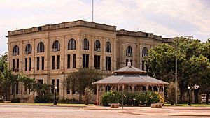
The Haskell County Courthouse
|
|

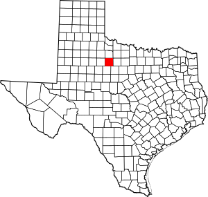
Location within the U.S. state of Texas
|
|
 Texas's location within the U.S. |
|
| Country | |
| State | |
| Founded | 1885 |
| Named for | Charles Ready Haskell |
| Seat | Haskell |
| Largest city | Haskell |
| Area | |
| • Total | 910 sq mi (2,400 km2) |
| • Land | 903 sq mi (2,340 km2) |
| • Water | 7.1 sq mi (18 km2) 0.8% |
| Population
(2020)
|
|
| • Total | 5,416 |
| • Density | 6.0/sq mi (2.3/km2) |
| Time zone | UTC−6 (Central) |
| • Summer (DST) | UTC−5 (CDT) |
| Congressional district | 19th |
Haskell County is a special area in the state of Texas, USA. It's like a big neighborhood with its own local government. In 2020, about 5,416 people lived here. The main town and place where the county government works is called Haskell.
Haskell County was first created in 1858 and officially started its government in 1885. It's named after Charles Ready Haskell. He was a brave soldier who was killed during a sad event called the Goliad massacre in Texas history.
Contents
Geography of Haskell County
Haskell County covers a total area of about 910 square miles. Most of this land is dry, about 903 square miles. A small part, about 7.1 square miles, is covered by water, like rivers or lakes.
Main Roads
These are the important highways that run through Haskell County:
Neighboring Counties
Haskell County shares its borders with several other counties:
- Knox County (to the north)
- Throckmorton County (to the east)
- Shackelford County (to the southeast)
- Jones County (to the south)
- Stonewall County (to the west)
- Baylor County (to the northeast)
- King County (to the northwest)
People of Haskell County
The number of people living in Haskell County has changed over the years.
| Historical population | |||
|---|---|---|---|
| Census | Pop. | %± | |
| 1880 | 48 | — | |
| 1890 | 1,665 | 3,368.8% | |
| 1900 | 2,637 | 58.4% | |
| 1910 | 16,249 | 516.2% | |
| 1920 | 14,193 | −12.7% | |
| 1930 | 16,669 | 17.4% | |
| 1940 | 14,905 | −10.6% | |
| 1950 | 13,736 | −7.8% | |
| 1960 | 11,174 | −18.7% | |
| 1970 | 8,512 | −23.8% | |
| 1980 | 7,725 | −9.2% | |
| 1990 | 6,820 | −11.7% | |
| 2000 | 6,093 | −10.7% | |
| 2010 | 5,899 | −3.2% | |
| 2020 | 5,416 | −8.2% | |
| U.S. Decennial Census 1850–2010 2010 2020 |
|||
In 2000, there were 6,093 people living in the county. About 20% of the people were of Hispanic or Latino background. The average age of people in the county was 44 years old. About 23.7% of the population was under 18 years old.
Towns and Communities
Haskell County has several towns and communities where people live and work.
Cities
- Haskell (This is the main town and county seat)
- O'Brien
- Stamford (A small part of this city is also in Jones County)
- Weinert
Towns
Small Communities (Unincorporated)
These are smaller places that don't have their own city government:
Old Abandoned Town
- Jud (This is a "ghost town," meaning it used to be a town but is now mostly abandoned.)
Education
Students in Haskell County go to schools in several different school districts:
- Haskell Consolidated Independent School District
- Knox City-O'Brien Consolidated Independent School District
- Munday Consolidated Independent School District
- Paint Creek Independent School District
- Rule Independent School District
- Stamford Independent School District
There used to be a school district called Goree Independent School District, but it joined with Munday Consolidated Independent School District in 2003. For higher education, the county is served by Vernon College.
See also
In Spanish: Condado de Haskell (Texas) para niños
 | John T. Biggers |
 | Thomas Blackshear |
 | Mark Bradford |
 | Beverly Buchanan |

