
Stonewall County, Texas facts for kids
Quick facts for kids
Stonewall County
|
|
|---|---|

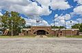
Stonewall County Courthouse in Aspermont
|
|

Location within the U.S. state of Texas
|
|
 Texas's location within the U.S. |
|
| Country | |
| State | |
| Founded | 1888 |
| Named for | Stonewall Jackson |
| Seat | Aspermont |
| Largest town | Aspermont |
| Area | |
| • Total | 920 sq mi (2,400 km2) |
| • Land | 916 sq mi (2,370 km2) |
| • Water | 3.9 sq mi (10 km2) 0.4% |
| Population
(2020)
|
|
| • Total | 1,245 |
| • Density | 1.353/sq mi (0.5225/km2) |
| Time zone | UTC−6 (Central) |
| • Summer (DST) | UTC−5 (CDT) |
| Congressional district | 19th |
Stonewall County is a special area in the state of Texas, USA. It's like a smaller region within the state, similar to a district. As of 2020, about 1,245 people live there. The main town, or "county seat," where the local government is located, is Aspermont.
The county was first created in 1876 and officially started operating in 1888. It was named after Stonewall Jackson, a famous general from the Confederate States Army during the American Civil War.
Contents
History of Stonewall County
Stonewall County was first formed in 1876. At first, it was part of other nearby counties like Young County, Throckmorton County, and Jones County. It wasn't until 1889 that Stonewall County became fully independent and organized its own government.
Geography and Nature
Stonewall County covers a total area of about 920 square miles (2,383 square kilometers). Most of this area, about 916 square miles (2,372 square kilometers), is land. Only a small part, about 3.9 square miles (10 square kilometers), is covered by water.
What are the main natural features?
Stonewall County has some interesting natural spots:
- Double Mountain: This is the highest point in the county. It's also the most noticeable hill for almost 160 miles (257 kilometers) around.
- Brazos River: One of Texas's major rivers, the Brazos River, actually starts right here in Stonewall County. It begins where two smaller rivers, the Double Mountain Fork and the Salt Fork Brazos River, join together. This spot is about 3 miles (4.8 km) west of a ghost town called Jud.
- Kiowa Peak: Another notable peak, located about 3 miles (4.8 km) west of the Brazos River.
Which counties are next to Stonewall County?
Stonewall County shares its borders with these other counties:
- King County to the north
- Haskell County to the east
- Jones County to the southeast
- Fisher County to the south
- Kent County to the west
Population and People
The number of people living in Stonewall County has changed over the years. Here's how the population has grown and shrunk:
| Historical population | |||
|---|---|---|---|
| Census | Pop. | %± | |
| 1880 | 104 | — | |
| 1890 | 1,024 | 884.6% | |
| 1900 | 2,183 | 113.2% | |
| 1910 | 5,320 | 143.7% | |
| 1920 | 4,086 | −23.2% | |
| 1930 | 5,667 | 38.7% | |
| 1940 | 5,589 | −1.4% | |
| 1950 | 3,679 | −34.2% | |
| 1960 | 3,017 | −18.0% | |
| 1970 | 2,397 | −20.6% | |
| 1980 | 2,406 | 0.4% | |
| 1990 | 2,013 | −16.3% | |
| 2000 | 1,693 | −15.9% | |
| 2010 | 1,490 | −12.0% | |
| 2020 | 1,245 | −16.4% | |
| U.S. Decennial Census 1850–2010 2010 2020 |
|||
In 2010, there were 1,490 people living in the county. The population density was about 2 people per square mile (0.8 people per square kilometer). Most people were White (87.7%), with smaller groups of Black or African American (2.6%), Native American (0.5%), and Asian (0.9%). About 14% of the population was Hispanic or Latino.
The average age of people in the county in 2010 was 44 years old. About 22.8% of the population was under 18 years old.
Towns and Communities
Stonewall County has one main town and a few smaller communities.
Town
- Aspermont: This is the county seat, meaning it's where the county government offices are located.
Unincorporated communities
These are smaller communities that don't have their own local government:
Ghost town
- Rath City: This was once a community but is now abandoned.
Transportation and Travel
Getting around Stonewall County is mainly done by road.
Main Highways
These are the most important roads that go through the county:
 U.S. Highway 83
 U.S. Highway 380
 State Highway 283
Air Travel
The county has its own public airport called Stonewall County Airport. It's located in Aspermont, about 1 nautical mile (1.9 km) northeast of the town center.
Education and Schools
Children in Stonewall County attend schools in several different school districts:
- Aspermont Independent School District
- Hamlin Independent School District
- Haskell Consolidated Independent School District
- Rotan Independent School District
- Rule Independent School District
For higher education, the county is part of the Western Texas College District.
Images for kids
-
Stonewall County Courthouse in Aspermont
See also
 In Spanish: Condado de Stonewall para niños
