Kent County, Texas facts for kids
Quick facts for kids
Kent County
|
|
|---|---|

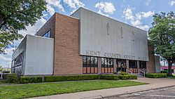
Kent County Courthouse in Jayton
|
|

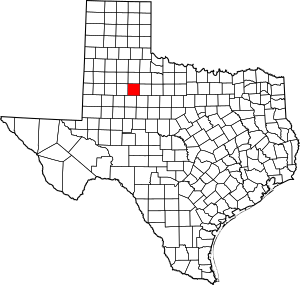
Location within the U.S. state of Texas
|
|
 Texas's location within the U.S. |
|
| Country | |
| State | |
| Founded | 1892 |
| Named for | Andrew Kent |
| Seat | Jayton |
| Largest city | Jayton |
| Area | |
| • Total | 903 sq mi (2,340 km2) |
| • Land | 903 sq mi (2,340 km2) |
| • Water | 0.4 sq mi (1 km2) 0.05% |
| Population
(2020)
|
|
| • Total | 753 |
| • Estimate
(2022)
|
740 |
| • Density | 0.8339/sq mi (0.3220/km2) |
| Time zone | UTC−6 (Central) |
| • Summer (DST) | UTC−5 (CDT) |
| Congressional district | 19th |
Kent County is a county in Texas, USA. In 2020, about 753 people lived here. This makes it one of the smallest counties in Texas. The main town and county seat is Jayton.
Kent County was created in 1876. It was officially set up in 1892. The county is named after Andrew Kent. He was a brave person who died at the famous Battle of the Alamo.
Contents
History timeline
- 8000 BC: The first people to live here were Paleo-Indians. Later, Native American groups like the Comanche lived in this area.
- 1872: Soldiers led by Ranald S. Mackenzie fought the Comanches. This happened near Treasure Butte.
- 1876: The Texas government created Kent County. It was formed from parts of Young and Bexar areas. The county was named after Andrew Kent.
- 1888: A cattle rancher named R. L. Rhomberg settled here. He named a new town Clairemont after his daughter.
- 1890: The county had 324 residents.
- 1891: Ranchers and farmers had disagreements. Farmers wanted to build fences for their land.
- 1892: Kent County was officially organized. Clairemont became the county seat.
- 1900: The number of people living in the county grew to 899.
- 1909: A railroad line was built across the county. This line connected Stamford and Spur. The town of Jayton was started around this time.
- 1930: The county's population reached its highest point. There were 3,851 people living here.
- 1946-1991: Oil was found in Kent County in 1946. Over 448 million barrels of oil were produced here.
Geography
Kent County is located in Texas. It covers a total area of about 903 square miles. Almost all of this area is land. Only a tiny part, about 0.4 square miles, is water.
Major roads
Neighboring counties
Kent County shares borders with several other counties:
- Dickens County (to the north)
- Stonewall County (to the east)
- Fisher County (to the southeast)
- Scurry County (to the south)
- Garza County (to the west)
- King County (to the northeast)
- Crosby County (to the northwest)
People and population
| Historical population | |||
|---|---|---|---|
| Census | Pop. | %± | |
| 1880 | 92 | — | |
| 1890 | 324 | 252.2% | |
| 1900 | 899 | 177.5% | |
| 1910 | 2,655 | 195.3% | |
| 1920 | 3,335 | 25.6% | |
| 1930 | 3,851 | 15.5% | |
| 1940 | 3,413 | −11.4% | |
| 1950 | 2,249 | −34.1% | |
| 1960 | 1,727 | −23.2% | |
| 1970 | 1,434 | −17.0% | |
| 1980 | 1,145 | −20.2% | |
| 1990 | 1,010 | −11.8% | |
| 2000 | 859 | −15.0% | |
| 2010 | 808 | −5.9% | |
| 2020 | 753 | −6.8% | |
| 2022 (est.) | 740 | −8.4% | |
| U.S. Decennial Census 1850–2010 2010-2020 |
|||
In 2000, there were 859 people living in Kent County. These people lived in 353 households. Most households, about 61%, were married couples. About 26% of households had children under 18.
The average age of people in the county was 47 years old. About 20% of the population was under 18. About 25% of the population was 65 or older.
Most people in Kent County are White. About 9% of the population is Hispanic or Latino.
Communities
City
- Jayton (This is the county seat.)
Other communities
- Clairemont (This is a ghost town, meaning it's mostly abandoned.)
- Girard (This is a small community.)
Education
Several school districts serve Kent County:
- Jayton-Girard Independent School District
- Post Independent School District
- Rotan Independent School District
- Snyder Independent School District
- Spur Independent School District
The county is also part of the Western Texas College District. This means students can attend Western Texas College.
See also
 In Spanish: Condado de Kent (Texas) para niños
 | Shirley Ann Jackson |
 | Garett Morgan |
 | J. Ernest Wilkins Jr. |
 | Elijah McCoy |

