
Scurry County, Texas facts for kids
Quick facts for kids
Scurry County
|
|
|---|---|

Scurry County Courthouse in Snyder
|
|

Location within the U.S. state of Texas
|
|
 Texas's location within the U.S. |
|
| Country | |
| State | |
| Founded | 1884 |
| Named for | William Read Scurry |
| Seat | Snyder |
| Largest city | Snyder |
| Area | |
| • Total | 908 sq mi (2,350 km2) |
| • Land | 905 sq mi (2,340 km2) |
| • Water | 2.1 sq mi (5 km2) 0.2% |
| Population
(2020)
|
|
| • Total | 16,932 |
| • Density | 18.648/sq mi (7.200/km2) |
| Time zone | UTC−6 (Central) |
| • Summer (DST) | UTC−5 (CDT) |
| Congressional district | 19th |

Scurry County is a county in the state of Texas. In 2020, about 16,932 people lived there. The main town and county seat is Snyder. This town is also home to Western Texas College.
Scurry County got its name from William Read Scurry, a general in the Confederate Army. The county was created in 1876 and officially started in 1884. For a long time, Scurry County had rules against selling alcohol. But in 2006, people voted to allow beer and wine sales in Snyder. Later, in 2008, they voted to allow stronger drinks to be sold across the whole county.
Scurry County is part of the Snyder, Texas, area, which is a smaller city area.
Contents
History of Scurry County
Scurry County was created in 1876. It officially began operating on June 28, 1884. It was named after William Read Scurry, who was a lawyer and a general. Before 1909, there were no railroads in the county. The closest places to ship goods were Colorado City and towns in Fisher County.
The first railroad, the Roscoe, Snyder and Pacific Railway, arrived around 1909. It connected Roscoe to Snyder, the county seat. This railway was later extended to Fluvanna, which is also in Scurry County. In 1911, another major railway line, the Santa Fe system, was built through the county. This helped Scurry County grow quickly in the early 1900s.
A key part of Scurry County's early history involves W.H. Snyder. The town of Snyder is named after him. In 1877, he set up a trading camp in the county. He brought lumber from Dallas by wagon to build his store. He also brought many goods from Dallas. He used large wagons pulled by seven teams of oxen.
Mr. Snyder built a house and started selling general goods and supplies. He sold things to buffalo hunters who were in the area. Other people soon moved to the same spot. This was the beginning of the town of Snyder.
In 1882, Mr. Snyder planned out the town. Two years later, it became the county seat. The people of Snyder were very active in building their community. Ten years later, the town had its own school district and four churches. It became an important place for trade. When the railway arrived, Snyder grew even more. In 1910, its population was 2,154 people. Other towns like Fluvanna and Hermleigh also grew along the railway lines.
Geography and Nature
Scurry County covers about 908 square miles. Most of this area, 905 square miles, is land. Only a small part, about 2.1 square miles, is covered by water.
Since 1952, Lake J. B. Thomas has been an important water source in Scurry County. When it's full, the lake can cover up to 7,282 acres.
Main Roads
 U.S. Highway 84
 U.S. Highway 180
 State Highway 208
 State Highway 350
Neighboring Counties
- Kent County (north)
- Fisher County (east)
- Mitchell County (south)
- Borden County (west)
- Garza County (northwest)
Population Facts
| Historical population | |||
|---|---|---|---|
| Census | Pop. | %± | |
| 1880 | 102 | — | |
| 1890 | 1,415 | 1,287.3% | |
| 1900 | 4,158 | 193.9% | |
| 1910 | 10,924 | 162.7% | |
| 1920 | 9,003 | −17.6% | |
| 1930 | 12,188 | 35.4% | |
| 1940 | 11,545 | −5.3% | |
| 1950 | 22,779 | 97.3% | |
| 1960 | 20,369 | −10.6% | |
| 1970 | 15,760 | −22.6% | |
| 1980 | 18,192 | 15.4% | |
| 1990 | 18,634 | 2.4% | |
| 2000 | 16,361 | −12.2% | |
| 2010 | 16,921 | 3.4% | |
| 2020 | 16,932 | 0.1% | |
| U.S. Decennial Census 1850–2010 2010 2020 |
|||
In 2000, Scurry County had 16,361 people living there. There were 5,756 households and 4,161 families. The population density was about 18 people per square mile.
About 25.2% of the people were under 18 years old. About 15.4% were 65 years or older. The average age was 37 years. For every 100 females, there were about 107.8 males.
The average income for a household in the county was $31,646. For a family, it was $38,467. About 16% of the population lived below the poverty line. This included 21.6% of those under 18.
Towns and Places
City
- Snyder (This is the main town and county seat)
Census-designated place
Small Communities
Old Town (Ghost Town)
- Pyron
Education
Several school districts serve Scurry County:
- Colorado Independent School District
- Hermleigh Independent School District
- Ira Independent School District
- Roscoe Collegiate Independent School District
- Snyder Independent School District
The Texas Legislature has also said that Scurry County is part of the Western Texas College District. This means students in the county can attend Western Texas College.
Gallery
-
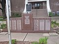
Veterans Monument at the Scurry County Courthouse
-
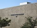
Scurry County Museum is located on the campus of Western Texas College in Snyder.
-
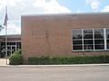
Scurry County Library in Snyder
-
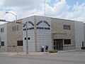
West Texas State Bank in Snyder serves Scurry County.
-
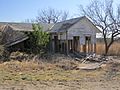
This old building, once the Dermott Post Office, is in northern Scurry County.
-
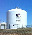
Water tank in Scurry County, Texas, near Snyder.


See also
 In Spanish: Condado de Scurry para niños
