Mitchell County, Texas facts for kids
Quick facts for kids
Mitchell County
|
|
|---|---|

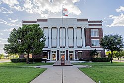
The Mitchell County Courthouse in Colorado City
|
|

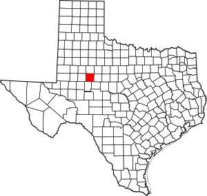
Location within the U.S. state of Texas
|
|
 Texas's location within the U.S. |
|
| Country | |
| State | |
| Founded | 1881 |
| Seat | Colorado City |
| Largest city | Colorado City |
| Area | |
| • Total | 916 sq mi (2,370 km2) |
| • Land | 911 sq mi (2,360 km2) |
| • Water | 4.8 sq mi (12 km2) 0.5% |
| Population
(2020)
|
|
| • Total | 8,990 |
| • Density | 9.814/sq mi (3.789/km2) |
| Time zone | UTC−6 (Central) |
| • Summer (DST) | UTC−5 (CDT) |
| Congressional district | 19th |
Mitchell County is a county in Texas, a state in the United States. In 2020, about 8,990 people lived there. The main town, or county seat, is Colorado City.
Mitchell County was created in 1876 and officially started in 1881. It is named after Asa and Eli Mitchell, who were early settlers and soldiers in the Texas Revolution.
Contents
Exploring Mitchell County's Geography
Mitchell County covers about 916 square miles. Most of this area is land, with a small part (about 4.8 square miles) covered by water. The county is home to two important lakes: Lake Colorado City and Lake Champion.
Main Roads in Mitchell County
These are the major highways that run through Mitchell County:
Neighboring Counties
Mitchell County shares borders with these other counties:
- Scurry County (to the north)
- Fisher County (to the northeast)
- Nolan County (to the east)
- Coke County (to the southeast)
- Sterling County (to the south)
- Howard County (to the west)
- Borden County (to the northwest)
Mitchell County's Population Story
| Historical population | |||
|---|---|---|---|
| Census | Pop. | %± | |
| 1880 | 117 | — | |
| 1890 | 2,059 | 1,659.8% | |
| 1900 | 2,855 | 38.7% | |
| 1910 | 8,956 | 213.7% | |
| 1920 | 7,527 | −16.0% | |
| 1930 | 14,183 | 88.4% | |
| 1940 | 12,477 | −12.0% | |
| 1950 | 14,357 | 15.1% | |
| 1960 | 11,255 | −21.6% | |
| 1970 | 9,073 | −19.4% | |
| 1980 | 9,088 | 0.2% | |
| 1990 | 8,016 | −11.8% | |
| 2000 | 9,698 | 21.0% | |
| 2010 | 9,403 | −3.0% | |
| 2020 | 8,990 | −4.4% | |
| U.S. Decennial Census 1850–2010 2010 2020 |
|||
In 2000, Mitchell County had 9,698 people living there. The population density was about 11 people per square mile.
About 30% of households had children under 18. Over half of the households were married couples living together. About 27% of households were individuals living alone. The average household had about 2.5 people.
The population was spread out by age. About 19% were under 18. About 30% were between 25 and 44 years old. About 15% were 65 or older. The average age in the county was 39 years.
The median income for a household was about $25,399. For families, it was about $31,481. About 17% of the population lived below the poverty line. This included about 22% of those under 18.
Towns and Communities
Mitchell County has several towns and communities.
Cities
- Colorado City (This is the main town, or county seat)
- Westbrook
Town
Census-Designated Place
Unincorporated Communities
These are smaller communities not officially part of a city or town:
Ghost Towns
These are places where people used to live, but now they are mostly empty:
- Cuthbert
- Hyman
- Iatan
- Spade
- Valley View
Education in Mitchell County
Students in Mitchell County attend schools in several different school districts:
- Colorado Independent School District
- Forsan Independent School District
- Ira Independent School District
- Loraine Independent School District
- Roscoe Collegiate Independent School District
- Westbrook Independent School District
The Texas Legislature has also said that Mitchell County is part of the Western Texas College District. This means students can attend Western Texas College.
See also
 In Spanish: Condado de Mitchell (Texas) para niños
 | Jackie Robinson |
 | Jack Johnson |
 | Althea Gibson |
 | Arthur Ashe |
 | Muhammad Ali |


