Coke County, Texas facts for kids
Quick facts for kids
Coke County
|
|
|---|---|

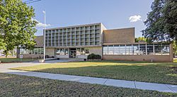
The Coke County Courthouse in Robert Lee
|
|

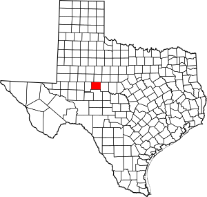
Location within the U.S. state of Texas
|
|
 Texas's location within the U.S. |
|
| Country | |
| State | |
| Founded | March 13, 1889 |
| Named for | Richard Coke |
| Seat | Robert Lee |
| Largest city | Robert Lee |
| Area | |
| • Total | 928 sq mi (2,400 km2) |
| • Land | 911 sq mi (2,360 km2) |
| • Water | 17 sq mi (40 km2) 1.8% |
| Population
(2020)
|
|
| • Total | 3,285 |
| • Density | 3.5399/sq mi (1.3668/km2) |
| Time zone | UTC−6 (Central) |
| • Summer (DST) | UTC−5 (CDT) |
| Congressional district | 11th |
Coke County is a place in Texas, a state in the United States. It is located on a high area called the Edwards Plateau. In 2020, about 3,285 people lived there. The main town and county seat is Robert Lee.
Coke County was started in 1889. It is named after Richard Coke, who was the 15th governor of Texas and later a U.S. senator. For a long time, Coke County was a "dry county," meaning you couldn't buy beer or wine. But in 2005, a new law allowed these sales.
Contents
History of Coke County
Early People and Settlements
For many years, from about 1700 to the 1870s, different Native American tribes lived in the area. These included the Comanche, Tonkawa, Lipan Apache, Kickapoo, and Kiowa. They often lived in rock shelters near rivers and creeks. They left behind tools, seeds, and even rock carvings.
In 1851, the United States Army built Fort Chadbourne to help protect the people living on the edge of the settled areas. Soldiers stayed at the fort until the American Civil War. From 1858 to 1861, the Butterfield Overland Mail route, which delivered mail across the country, passed through this area.
Between 1860 and the early 1880s, only a few ranchers lived in what would become Coke County. They were drawn to the wide-open lands for their cattle. More settlers started to arrive after 1882, when the Texas and Pacific Railway began service to nearby San Angelo.
During the 1880s, a bad drought caused problems between ranchers. This led to something called the Fence Cutting War, where people cut fences to get to water and grazing land. State leaders eventually helped solve these disagreements. A few years later, the county was named after Richard Coke, a soldier, governor, and senator.
Forming the County
The Texas government officially created Coke County in 1889. It was formed from a part of Tom Green County. The county was organized that same year, and a town called Hayrick became its first county seat. The first newspaper in the county, the Hayrick Democrat, started in 1889.
In 1891, the people voted to move the county seat to a new town called Robert Lee. This town was named after Robert E. Lee, a famous general who had once served at Fort Chadbourne. The county newspaper also moved to Robert Lee and was renamed the Robert Lee Observer.
Developing Towns
- Bronte: Dr. D.W. Key helped start the town of Bronte. It was named after the famous English writer Charlotte Brontë. The town was first called Oso, then Bronco, before becoming Bronte. It got a post office in 1890.
- Silver: The town of Silver was settled between 1870 and 1880. It was a center for ranching. In the mid-1900s, oil was found nearby, and Silver grew quickly. But after the oil camps closed in 1966, many people moved away.
- Tennyson: Tennyson was started in 1892 and named after the British poet Alfred, Lord Tennyson. It got a post office two years later.
In 1907, a railroad called the Kansas City, Mexico and Orient Railway built tracks through the county. This helped the towns of Tennyson, Bronte, and Fort Chadbourne grow.
Farming changed a lot in the county. Cotton growing was very popular around 1910, but it dropped sharply in the 1920s because of tiny insects called boll weevils. Farmers then started growing more corn, wheat, and other crops. During the Great Depression, many people left the county.
Oil was discovered in Coke County in 1942. Over the years, millions of barrels of oil have been taken from the land. The money from oil taxes has helped the county improve its roads, buildings, and services for its citizens. Today, oil production is a major source of income for Coke County.
Geography
Coke County covers a total area of about 928 square miles. Most of this (911 square miles) is land, and about 17 square miles (1.8%) is covered by water.
Main Roads
- U.S. Highway 277
- State Highway 158
- State Highway 208
Neighboring Counties
Coke County shares borders with these other counties:
- Nolan County (north)
- Runnels County (east)
- Tom Green County (south)
- Sterling County (west)
- Mitchell County (northwest)
People of Coke County (Demographics)
| Historical population | |||
|---|---|---|---|
| Census | Pop. | %± | |
| 1890 | 2,059 | — | |
| 1900 | 3,430 | 66.6% | |
| 1910 | 6,412 | 86.9% | |
| 1920 | 4,557 | −28.9% | |
| 1930 | 5,253 | 15.3% | |
| 1940 | 4,590 | −12.6% | |
| 1950 | 4,045 | −11.9% | |
| 1960 | 3,589 | −11.3% | |
| 1970 | 3,087 | −14.0% | |
| 1980 | 3,196 | 3.5% | |
| 1990 | 3,424 | 7.1% | |
| 2000 | 3,864 | 12.9% | |
| 2010 | 3,320 | −14.1% | |
| 2020 | 3,285 | −1.1% | |
| U.S. Decennial Census 1850–2010 2010 2020 |
|||
The table below shows the different groups of people living in Coke County over the years. The U.S. Census counts people by their race and also by whether they are of Hispanic or Latino background.
| Race / Ethnicity (NH = Non-Hispanic) | Pop 2000 | Pop 2010 | Pop 2020 | % 2000 | % 2010 | % 2020 |
|---|---|---|---|---|---|---|
| White alone (NH) | 3,079 | 2,651 | 2,473 | 79.68% | 79.85% | 75.28% |
| Black or African American alone (NH) | 74 | 7 | 7 | 1.92% | 0.21% | 0.21% |
| Native American or Alaska Native alone (NH) | 27 | 19 | 15 | 0.70% | 0.57% | 0.46% |
| Asian alone (NH) | 3 | 5 | 1 | 0.08% | 0.15% | 0.03% |
| Pacific Islander alone (NH) | 1 | 1 | 6 | 0.03% | 0.03% | 0.18% |
| Other race alone (NH) | 3 | 0 | 6 | 0.08% | 0.00% | 0.18% |
| Mixed race or Multiracial (NH) | 24 | 35 | 116 | 0.62% | 1.05% | 3.53% |
| Hispanic or Latino (any race) | 653 | 602 | 661 | 16.90% | 18.13% | 20.12% |
| Total | 3,864 | 3,320 | 3,285 | 100.00% | 100.00% | 100.00% |
In 2000, there were 3,864 people living in Coke County. There were 1,544 households, and 1,068 families. The population density was about four people for every square mile.
About 27% of households had children under 18 living with them. Most households (58.4%) were married couples. About 24% of the population was under 18 years old, and 24% was 65 years or older. The average age was 43 years.
Communities
Cities
- Blackwell (most of it is in Nolan County)
- Robert Lee (this is the county seat, or main town)
Town
Unincorporated Communities
These are smaller communities that are not officially cities or towns.
Ghost Towns
These are towns that used to exist but are now mostly abandoned.
- Edith
- Fort Chadbourne
Education
Students in Coke County attend schools in these independent school districts:
- Blackwell Consolidated Independent School District
- Bronte Independent School District
- Robert Lee Independent School District
- Water Valley Independent School District
See also
 In Spanish: Condado de Coke para niños
 | Leon Lynch |
 | Milton P. Webster |
 | Ferdinand Smith |


