
Sterling County, Texas facts for kids
Quick facts for kids
Sterling County
|
|
|---|---|

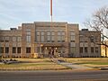
Sterling County Court House off U.S. Highway 87 in Sterling City
|
|

Location within the U.S. state of Texas
|
|
 Texas's location within the U.S. |
|
| Country | |
| State | |
| Founded | 1891 |
| Named for | W. S. Sterling, an early settler |
| Seat | Sterling City |
| Largest city | Sterling City |
| Area | |
| • Total | 924 sq mi (2,390 km2) |
| • Land | 923 sq mi (2,390 km2) |
| • Water | 0.1 sq mi (0.3 km2) 0.01% |
| Population
(2020)
|
|
| • Total | 1,372 |
| • Density | 1.4848/sq mi (0.5733/km2) |
| Time zone | UTC−6 (Central) |
| • Summer (DST) | UTC−5 (CDT) |
| Congressional district | 11th |
Sterling County is a county in Texas, located on the Edwards Plateau. In 2020, about 1,372 people lived there. This makes it one of the least populated counties in Texas.
The main town and county seat is Sterling City. The county is named after W. S. Sterling, who was one of the first settlers in the area. Sterling County used to be a "dry county," meaning it was against the law to sell alcohol there. Now, it is a "moist county," which means some alcohol sales are allowed.
Contents
History of Sterling County
Early People and Encounters
Long ago, different groups of Plains Indians lived in this area. These included the Comanche, Lipan Apache, Kiowa, and Kickapoo.
There were some conflicts between the Comanche people, local ranchers, and Texas Rangers. One event happened in the 1870s on Lacy Creek, involving ranchers and the Comanche. Another important event in 1879 was a battle between the Texas Rangers and the Comanche, led by Chief Black Horse, on the "U" Ranch.
First Settlers Arrive
Even though the county was part of a large land grant in 1842, no towns were built there at first. Fur traders, Texas Rangers, and soldiers traveled through the area between 1800 and 1860.
After the American Civil War, more settlers began to arrive. This was after the large herds of buffalo were gone and most Native American tribes had moved. W. S. Sterling, who was a buffalo hunter, settled here around 1858. He later became a U.S. Marshal in Arizona. Another buffalo hunter, S. J. Wiley, also settled in the county around the same time.
There's a story that famous outlaws Frank and Jesse James hid out on Sterling Creek in the 1870s. They were said to be raising horses and hunting buffalo. A place called Camp Elizabeth started as a Texas Ranger camp around 1853. It later became a small hospital for Fort Concho from 1874 to 1886.
Ranching and Land Ownership
In the early days, much of the land was open for grazing cattle. Large ranches like the Half Circle S, MS, and "U" Ranch were very important. The "U" Ranch was one of the first big ranches west of San Angelo. It was started in 1876 by J.D. Earnest and W.J. Holland.
Colonel William Randolph McEntire bought the "U" Ranch in 1880. Over time, the ranch grew to be very large, covering over 250,000 acres (1,012 km2). It even bordered other big ranches like the Seven-D Ranch. At its largest, the "U" Ranch controlled about 500,000 acres (2,023 km2) and grazed as many as 50,000 cattle across five counties.
Ranchers would drive their cattle long distances to places like Colorado City and Fort Worth. From there, the cattle were shipped by train to other states or to markets.
The "U" Ranch Today
The "U" Ranch has a lasting legacy. Parts of the original ranch are still owned and run by the descendants of W.R. McEntire. These ranches are the only remaining parts of the first large cattle ranch in the area.
In 1906, W.R. McEntire divided his ranching lands between his two sons, R. Billie McEntire and George H. McEntire.
- Fowler McEntire's grandson, Mackey McEntire, still uses the original "U" Ranch brand on his ranch today.
- James H. McEntire developed the Campstool Ranch. This ranch grew to include about 35,000 acres (142 km2) across four counties. In the 1960s, a large sheep feedlot was built on the Campstool Ranch. The family also started a company called Custom Skins, Inc., which became a leading supplier of sheepskin.
George H. McEntire continued to operate his part of the "U" Ranch with his father. Later, his children, George H. McEntire, Jr. and Virginia McEntire, took over. The ranch is now owned by Ruth Caldwell, who is George H. McEntire, Jr.'s daughter.
Fence Cutting Wars
In the 1880s, Sterling County faced dry weather. This led to conflicts known as the Fence Cutting Wars. As more settlers arrived and fenced their land, it became harder for large cattle herds to find food and water. Sometimes, big landowners would even fence off public land.
During droughts, settlers and ranch workers started cutting fences to get access to land and water. Texas Governor John Ireland asked the state government to stop the fence cutters. The government then made it a crime to cut fences or burn pastures. This helped to reduce the conflicts, but some problems continued until 1888.
County Growth and Changes
Sterling County was officially created and organized in 1891 from Tom Green County. There was a competition between Sterling City and Cummins to be the county seat. Sterling City won, and most people from Cummins moved there, making Cummins a ghost town.
Around 1890, sheep ranching became popular in the area. Cotton was also planted, and Sterling City opened its first cotton gin in 1895. However, it soon became clear that the land was best suited for grazing animals. Cotton farming decreased, and ranching continued to grow.
The county's economy struggled during the Great Depression in the 1930s. But in 1947, oil was discovered in Sterling County, which helped the economy recover. By 1991, a lot of oil had been taken from the county.
Geography of Sterling County
Sterling County covers about 924 square miles (2,393 km2) of land. Only a very small part, about 0.1 square miles (0.26 km2), is covered by water.
Main Roads
 U.S. Highway 87
 State Highway 158
 State Highway 163
Neighboring Counties
Sterling County is next to these other counties:
- Mitchell County (north)
- Coke County (east)
- Tom Green County (southeast and south)
- Reagan County (southwest)
- Glasscock County (west)
- Howard County (northwest)
Population Information
| Historical population | |||
|---|---|---|---|
| Census | Pop. | %± | |
| 1900 | 1,127 | — | |
| 1910 | 1,493 | 32.5% | |
| 1920 | 1,053 | −29.5% | |
| 1930 | 1,431 | 35.9% | |
| 1940 | 1,404 | −1.9% | |
| 1950 | 1,282 | −8.7% | |
| 1960 | 1,177 | −8.2% | |
| 1970 | 1,056 | −10.3% | |
| 1980 | 1,206 | 14.2% | |
| 1990 | 1,438 | 19.2% | |
| 2000 | 1,393 | −3.1% | |
| 2010 | 1,143 | −17.9% | |
| 2020 | 1,372 | 20.0% | |
| U.S. Decennial Census 1850–2010 2010 2020 |
|||
| Race / Ethnicity (NH = Non-Hispanic) | Pop 2000 | Pop 2010 | Pop 2020 | % 2000 | % 2010 | % 2020 |
|---|---|---|---|---|---|---|
| White alone (NH) | 955 | 733 | 867 | 68.56% | 64.13% | 63.19% |
| Black or African American alone (NH) | 1 | 13 | 3 | 0.07% | 1.14% | 0.22% |
| Native American or Alaska Native alone (NH) | 3 | 13 | 4 | 0.22% | 1.14% | 0.29% |
| Asian alone (NH) | 0 | 0 | 1 | 0.00% | 0.00% | 0.07% |
| Pacific Islander alone (NH) | 1 | 0 | 2 | 0.07% | 0.00% | 0.15% |
| Other Race alone (NH) | 0 | 2 | 2 | 0.00% | 0.17% | 0.15% |
| Mixed Race or Multiracial (NH) | 1 | 17 | 44 | 0.07% | 1.49% | 3.21% |
| Hispanic or Latino (any race) | 432 | 365 | 449 | 31.01% | 31.93% | 32.73% |
| Total | 1,393 | 1,143 | 1,372 | 100.00% | 100.00% | 100.00% |
In 2000, there were 1,393 people living in Sterling County. The population density was about 2 people per square mile (0.77 people per km2).
Out of 513 households, about 36.8% had children under 18 living with them. Most households (64.1%) were married couples. The average household had 2.67 people.
The median age in the county was 38 years old. About 28.7% of the population was under 18.
The median income for a household was $35,129. For a family, it was $37,813. About 16.8% of the population lived below the poverty line.
Towns and Communities
- Broome
- Sterling City (the main town)
Images for kids
-
Sterling County Court House off U.S. Highway 87 in Sterling City
See also
 In Spanish: Condado de Sterling para niños
