
Sterling City, Texas facts for kids
Quick facts for kids
Sterling City, Texas
|
|
|---|---|

U.S. Highway 87 as it passes through Sterling City, Texas
|
|
| Nickname(s):
The Windmill City
|
|

Location of Sterling City, Texas
|
|
 |
|
| Country | United States |
| State | Texas |
| County | Sterling |
| Area | |
| • Total | 0.98 sq mi (2.54 km2) |
| • Land | 0.98 sq mi (2.54 km2) |
| • Water | 0.00 sq mi (0.00 km2) |
| Elevation | 2,287 ft (697 m) |
| Population
(2020)
|
|
| • Total | 1,121 |
| • Density | 1,143.88/sq mi (441.34/km2) |
| Time zone | UTC-6 (Central (CST)) |
| • Summer (DST) | UTC-5 (CDT) |
| ZIP code |
76951
|
| Area code(s) | 325 |
| FIPS code | 48-70232 |
| GNIS feature ID | 1347899 |
| Website | sterlingcitytexas.com |
Sterling City is a small town in Texas, United States. It is the main town, or county seat, of Sterling County, Texas. In 2020, about 1,121 people lived there.
Contents
History of Sterling City
Sterling City was named after W.S. Sterling, a frontiersman. The town started in January 1891 when R.C. Stewart gave land for it. H.B. Tarver planned out the town's streets and lots. Later that same year, it became the main town for Sterling County.
Sterling City quickly grew to 300 people. It had its own newspaper, a hotel, a post office, and other businesses. There was also a school and three churches.
By 1910, Sterling City was a stop on the Santa Fe Railroad. This train service later stopped, but the old train station is still there for visitors to see.
During World War II, the number of people living in Sterling City went down by 10%. In August 1955, the town officially became a city. At that time, about 800 people lived there. The city had grown to include three more churches, a hospital, a bank, and a library.
On May 25, 1955, a sad event happened near Sterling City. Fifteen United States Air Force members died when their B-36 bomber plane crashed.
Geography and Windmills
Sterling City is located in west-central Texas. It sits on the Edwards Plateau near the North Concho River. You can reach the city by U.S. Highway 87 and State Highways 158 and 163. The city covers about 0.98 square miles (2.5 square kilometers) of land.
The Windmill City
Windmills have been a big part of Sterling City's story for a long time. In the early 1900s, the town was famous for having many windmills. People said it had more windmills per acre than anywhere else in the world, with around 300 of them.
Today, most of Sterling City's windmills are huge modern wind turbines. These giant turbines are part of wind farms. They are located on a ridge about 20 miles northwest of the town. You can see them from U.S. Highway 87.
Climate Information
| Climate data for Sterling City, Texas (1991–2020 normals, extremes 1963–2019) | |||||||||||||
|---|---|---|---|---|---|---|---|---|---|---|---|---|---|
| Month | Jan | Feb | Mar | Apr | May | Jun | Jul | Aug | Sep | Oct | Nov | Dec | Year |
| Record high °F (°C) | 87 (31) |
94 (34) |
98 (37) |
102 (39) |
109 (43) |
112 (44) |
109 (43) |
108 (42) |
106 (41) |
104 (40) |
93 (34) |
86 (30) |
112 (44) |
| Mean daily maximum °F (°C) | 57.5 (14.2) |
61.8 (16.6) |
69.1 (20.6) |
77.8 (25.4) |
84.8 (29.3) |
91.1 (32.8) |
93.5 (34.2) |
92.9 (33.8) |
85.8 (29.9) |
77.3 (25.2) |
65.9 (18.8) |
58.3 (14.6) |
76.3 (24.6) |
| Daily mean °F (°C) | 43.7 (6.5) |
47.6 (8.7) |
55.3 (12.9) |
63.8 (17.7) |
72.9 (22.7) |
79.6 (26.4) |
82.3 (27.9) |
81.6 (27.6) |
74.2 (23.4) |
64.4 (18.0) |
52.5 (11.4) |
44.7 (7.1) |
63.6 (17.6) |
| Mean daily minimum °F (°C) | 29.9 (−1.2) |
33.5 (0.8) |
41.5 (5.3) |
49.8 (9.9) |
60.9 (16.1) |
68.2 (20.1) |
71.0 (21.7) |
70.3 (21.3) |
62.5 (16.9) |
51.5 (10.8) |
39.2 (4.0) |
31.2 (−0.4) |
50.8 (10.4) |
| Record low °F (°C) | 1 (−17) |
−13 (−25) |
4 (−16) |
20 (−7) |
30 (−1) |
45 (7) |
47 (8) |
50 (10) |
32 (0) |
23 (−5) |
10 (−12) |
−7 (−22) |
−13 (−25) |
| Average precipitation inches (mm) | 0.95 (24) |
0.97 (25) |
1.27 (32) |
1.32 (34) |
2.75 (70) |
2.06 (52) |
1.68 (43) |
2.42 (61) |
2.45 (62) |
2.46 (62) |
1.20 (30) |
0.87 (22) |
20.40 (518) |
| Average snowfall inches (cm) | 0.1 (0.25) |
0.4 (1.0) |
0.0 (0.0) |
0.0 (0.0) |
0.0 (0.0) |
0.0 (0.0) |
0.0 (0.0) |
0.0 (0.0) |
0.0 (0.0) |
0.0 (0.0) |
0.5 (1.3) |
0.5 (1.3) |
1.5 (3.8) |
| Average precipitation days (≥ 0.01 in) | 3.2 | 3.1 | 3.9 | 3.6 | 5.7 | 4.7 | 4.0 | 4.6 | 3.9 | 4.2 | 2.8 | 2.5 | 46.2 |
| Average snowy days (≥ 0.1 in) | 0.2 | 0.3 | 0.0 | 0.0 | 0.0 | 0.0 | 0.0 | 0.0 | 0.0 | 0.0 | 0.2 | 0.3 | 1.0 |
| Source: NOAA | |||||||||||||
People of Sterling City
| Historical population | |||
|---|---|---|---|
| Census | Pop. | %± | |
| 1960 | 854 | — | |
| 1970 | 780 | −8.7% | |
| 1980 | 915 | 17.3% | |
| 1990 | 1,096 | 19.8% | |
| 2000 | 1,081 | −1.4% | |
| 2010 | 888 | −17.9% | |
| 2020 | 1,121 | 26.2% | |
| U.S. Decennial Census | |||
In 2020, the 2020 United States census counted 1,121 people living in Sterling City. There were 344 households and 291 families. Most people living in Sterling City are White (58.16%). A large part of the population, 37.64%, is Hispanic or Latino.
Education in Sterling City
The Sterling City Independent School District serves the city of Sterling City. Students attend Sterling City High School, where their sports teams are known as the Eagles.
Images for kids
-
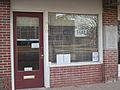
City Hall is located across from the courthouse in Sterling City.
-
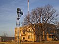
A windmill on the courthouse grounds in Sterling City
-
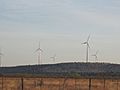
Wind turbines off U.S. Highway 87 south of Sterling City
-
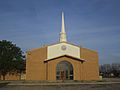
First Baptist Church at 401 Water Street in Sterling City, pastor, Jason McGuire (2013)


See also
 In Spanish: Sterling City (Texas) para niños
