
Snyder, Texas facts for kids
Quick facts for kids
Snyder, Texas
|
|
|---|---|

Downtown Snyder
|
|

Location of Snyder, Texas
|
|
| Country | United States |
| State | Texas |
| County | Scurry |
| Area | |
| • Total | 8.97 sq mi (23.23 km2) |
| • Land | 8.94 sq mi (23.15 km2) |
| • Water | 0.03 sq mi (0.08 km2) |
| Elevation | 2,320 ft (707 m) |
| Population
(2020)
|
|
| • Total | 11,438 |
| • Estimate
(2022)
|
11,230 |
| • Density | 1,275.1/sq mi (492.38/km2) |
| Time zone | UTC−6 (Central (CST)) |
| • Summer (DST) | UTC−5 (CDT) |
| ZIP codes |
79549-79550
|
| Area code(s) | 325 |
| FIPS code | 48-68624 |
| GNIS feature ID | 1347340 |
| Website | http://ci.snyder.tx.us/ |
Snyder is a city in Texas, United States. It is the main city, or county seat, of Scurry County, Texas. In 2020, about 11,438 people lived there. Snyder is located in a flat, high area of Texas called the Southwestern Tablelands.
Contents
Discovering Snyder, Texas
A Look Back at Snyder's Past
Snyder got its name from a merchant and buffalo hunter named William Henry (Pete) Snyder. He built a trading post by Deep Creek in 1878. Other hunters soon joined him, and a small town grew. Because the first homes were made of buffalo hides and tree branches, people first called the community "Hide Town." Another early nickname was "Robber's Roost." This name came from some of the less-than-lawful residents and the lack of police back then.
Today, a statue of an albino buffalo stands at the Scurry County Courthouse in Snyder. It reminds everyone of the town's early days as a buffalo trading spot.
Snyder was planned in 1882, two years before Scurry County was officially set up in 1884. By 1892, about 600 people lived there. The town had a school, two churches, a mill, and two banks. Big changes happened in 1907 when Snyder became an official city. The Roscoe, Snyder and Pacific Railway also began building tracks to the town. By 1910, Snyder's population had grown to 2,514. More growth came in 1911 when the Atchison, Topeka & Santa Fe Railway tracks arrived. For the first half of the 1900s, ranching and farming were the main ways people made a living in Snyder.
Things changed a lot in 1948. Oil was found in the Canyon Reef area north of town. Snyder quickly became a "boomtown." Its population jumped to about 12,000 in just one year! At its peak in 1951, about 16,000 people lived there. After the oil boom slowed down, the population settled around 10,000 to 11,000. Even though the boom ended, oil is still very important to Snyder's economy. The Snyder area is one of the top oil-producing places in Texas. In 1973, the oil fields nearby produced their one-billionth barrel of oil.
In the 1960s and early 1970s, Snyder started to build more factories. This helped the town's economy become more diverse. It meant the town was less affected by big ups and downs in the oil industry. Higher education also came to Snyder in 1971 with the start of Western Texas College.
The Scurry County Coliseum in Snyder is a large arena. Western Texas College has managed it since 2008. It hosts many events for the area. Outside the coliseum, you can see an old train engine and a small, restored historic village. Snyder is also home to the Diamond M Museum. A local oilman and rancher, Clarence T. McLaughlin, started this museum. It has over 80 bronze sculptures and 200 paintings, including works by famous artists like Peter Hurd and Andrew Wyeth.
Snyder's Location and Surroundings
Snyder is located on Deep Creek. This creek is a small branch of the Colorado River in Texas.
The city is about 90 miles (145 km) southeast of Lubbock. It's also about 80 miles (129 km) northwest of Abilene. Midland is about 90 miles (145 km) northeast, and San Angelo is about 100 miles (161 km) north.
Snyder's Weather
Snyder has a climate with hot summers and mild winters.
| Climate data for Snyder, Texas (1991–2020 normals, extremes 1911–present) | |||||||||||||
|---|---|---|---|---|---|---|---|---|---|---|---|---|---|
| Month | Jan | Feb | Mar | Apr | May | Jun | Jul | Aug | Sep | Oct | Nov | Dec | Year |
| Record high °F (°C) | 86 (30) |
92 (33) |
99 (37) |
104 (40) |
110 (43) |
114 (46) |
114 (46) |
115 (46) |
108 (42) |
102 (39) |
91 (33) |
87 (31) |
115 (46) |
| Mean maximum °F (°C) | 77.2 (25.1) |
81.3 (27.4) |
88.1 (31.2) |
93.6 (34.2) |
99.7 (37.6) |
101.8 (38.8) |
102.7 (39.3) |
101.6 (38.7) |
97.7 (36.5) |
92.5 (33.6) |
82.9 (28.3) |
76.7 (24.8) |
105.0 (40.6) |
| Mean daily maximum °F (°C) | 57.0 (13.9) |
61.5 (16.4) |
69.7 (20.9) |
78.3 (25.7) |
85.7 (29.8) |
92.4 (33.6) |
95.6 (35.3) |
94.4 (34.7) |
87.0 (30.6) |
78.0 (25.6) |
66.0 (18.9) |
57.7 (14.3) |
76.9 (24.9) |
| Daily mean °F (°C) | 43.0 (6.1) |
46.8 (8.2) |
55.0 (12.8) |
63.2 (17.3) |
72.1 (22.3) |
79.7 (26.5) |
82.9 (28.3) |
82.0 (27.8) |
74.5 (23.6) |
64.4 (18.0) |
52.2 (11.2) |
44.1 (6.7) |
63.3 (17.4) |
| Mean daily minimum °F (°C) | 28.3 (−2.1) |
31.9 (−0.1) |
39.2 (4.0) |
47.4 (8.6) |
58.3 (14.6) |
66.3 (19.1) |
69.6 (20.9) |
68.7 (20.4) |
61.3 (16.3) |
50.5 (10.3) |
38.2 (3.4) |
28.8 (−1.8) |
49.0 (9.4) |
| Mean minimum °F (°C) | 16.2 (−8.8) |
19.3 (−7.1) |
25.2 (−3.8) |
34.0 (1.1) |
44.9 (7.2) |
58.9 (14.9) |
64.7 (18.2) |
63.2 (17.3) |
49.0 (9.4) |
35.5 (1.9) |
23.9 (−4.5) |
17.1 (−8.3) |
12.4 (−10.9) |
| Record low °F (°C) | −10 (−23) |
−11 (−24) |
5 (−15) |
20 (−7) |
29 (−2) |
40 (4) |
52 (11) |
46 (8) |
35 (2) |
19 (−7) |
4 (−16) |
−3 (−19) |
−11 (−24) |
| Average precipitation inches (mm) | 0.77 (20) |
1.05 (27) |
1.56 (40) |
1.40 (36) |
2.68 (68) |
3.14 (80) |
1.91 (49) |
2.09 (53) |
2.75 (70) |
2.17 (55) |
1.19 (30) |
1.06 (27) |
21.77 (553) |
| Average snowfall inches (cm) | 0.1 (0.25) |
0.5 (1.3) |
0.0 (0.0) |
0.0 (0.0) |
0.0 (0.0) |
0.0 (0.0) |
0.0 (0.0) |
0.0 (0.0) |
0.0 (0.0) |
0.0 (0.0) |
0.4 (1.0) |
0.8 (2.0) |
1.8 (4.6) |
| Average precipitation days (≥ 0.01 in) | 3.5 | 4.4 | 5.3 | 4.0 | 6.8 | 6.2 | 4.6 | 5.4 | 5.6 | 5.3 | 3.7 | 4.0 | 58.8 |
| Average snowy days (≥ 0.1 in) | 0.0 | 0.2 | 0.0 | 0.0 | 0.0 | 0.0 | 0.0 | 0.0 | 0.0 | 0.0 | 0.0 | 0.3 | 0.5 |
| Source: NOAA | |||||||||||||
People Living in Snyder
| Historical population | |||
|---|---|---|---|
| Census | Pop. | %± | |
| 1890 | 500 | — | |
| 1910 | 2,514 | — | |
| 1920 | 2,179 | −13.3% | |
| 1930 | 3,008 | 38.0% | |
| 1940 | 3,815 | 26.8% | |
| 1950 | 12,010 | 214.8% | |
| 1960 | 13,850 | 15.3% | |
| 1970 | 11,171 | −19.3% | |
| 1980 | 12,705 | 13.7% | |
| 1990 | 12,195 | −4.0% | |
| 2000 | 10,783 | −11.6% | |
| 2010 | 11,202 | 3.9% | |
| 2020 | 11,438 | 2.1% | |
| 2022 (est.) | 11,230 | 0.2% | |
| U.S. Decennial Census | |||
The United States Census counts how many people live in different places. In 2020, Snyder had 11,438 residents. There were 4,360 households and 2,843 families.
Snyder's Population in 2020
| Group | Number of People | Percentage |
|---|---|---|
| White (NH) | 5,014 | 43.84% |
| Black or African American (NH) | 375 | 3.28% |
| Native American or Alaska Native (NH) | 45 | 0.39% |
| Asian (NH) | 74 | 0.65% |
| Pacific Islander (NH) | 4 | 0.03% |
| Other Race (NH) | 24 | 0.21% |
| Mixed/Multi-Racial (NH) | 257 | 2.25% |
| Hispanic or Latino | 5,645 | 49.35% |
| Total | 11,438 |
Snyder's Population in 2010
In 2010, Snyder had 11,202 people. The city had about 1,257 people per square mile.
- 79% of the people were White.
- 4.69% were African American.
- 0.57% were Native American.
- 0.25% were Asian.
- 13.68% were from other races.
- 1.81% were from two or more races.
- About 31.8% of the population was Hispanic or Latino.
Of the households, 34.9% had children under 18. About 55.3% were married couples. The average household had 2.56 people. The average family had 3.10 people. The median age in the city was 36 years old.
Snyder's Economy and Jobs
Snyder's economy mainly relies on the oil, gas, and wind industries. In 2012, 994 new jobs were created in Snyder. This led to a 20% growth in jobs for the community.
The Scurry Area Canyon Reef Operators oilfield nearby is one of the largest and most productive in the United States. Snyder is also located near the recently found Cline Shale. This is another important oil and gas area. Two of the largest wind farms in the United States are also located near Snyder. Other important industries in Snyder include manufacturing and cotton farming.
The Texas Department of Criminal Justice also runs a distribution center in Snyder.
Learning in Snyder
The Snyder Independent School District serves the students in Snyder. The schools include:
- Snyder Primary
- Snyder Intermediate
- Snyder Junior High School
- Snyder Academy
- Snyder Christian School
- Snyder High School
Western Texas College is a two-year community college in Snyder. Besides regular college courses, it offers many career and technical programs. These include communication design, early childhood education, and petroleum technology. The Texas Legislature has said that Scurry County is part of the Western Texas College District.
Famous People from Snyder
Many interesting people have connections to Snyder:
- Kevin Alejandro (born 1976) – An actor who grew up in Snyder. He has been in TV shows like Ugly Betty and True Blood.
- Powers Boothe (1948–2017) – An Emmy-Award-winning actor born in Snyder. He was known for roles in Tombstone and Sin City.
- Sonny Cumbie (born 1981) – A football coach. He was a top college quarterback for Texas Tech University.
- Charlene Holt – An actress and model born in Snyder. She starred in the Western film El Dorado (1966 film).
- Dick Jones (1927–2014) – An actor from Snyder. He was the voice of the main character in the 1940 Disney film Pinocchio.
- Charley Lockhart – Born and raised in Snyder, he was a politician. He was known as "the smallest elected official in the biggest state."
- Brad Maule (born 1951) – An actor known for his role as Dr. Tony Jones on General Hospital. He graduated from Snyder High School.
- Dave McGinnis – A football coach who graduated from Snyder High School. He was a head coach for the NFL's Arizona Cardinals.
- Barry Tubb – An actor born in Snyder.
- Christian Wiman (born 1966) – A poet and professor who was raised in Snyder.
Images for kids
-
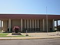
The Scurry County Coliseum in Snyder, has been operated since 2008 by Western Texas College.
-
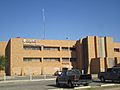
Cogdell Memorial Hospital is located near Western Texas College in Snyder
-
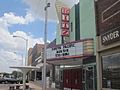
Ritz Theater in downtown Snyder
-
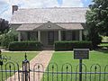
This 19th-century pioneer house, was constructed by physician and Confederate veteran J.C. Cornelius. The restored home now serves as a museum.


See also
 In Spanish: Snyder (Texas) para niños
